Lover, Pennsylvania

Last updated
Lover, Pennsylvania
Unincorporated community
USA Pennsylvania location map.svg
Red pog.svg
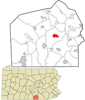
Lover, Pennsylvania
Location within the state of Pennsylvania
Coordinates: 40°06′45″N79°57′01″W / 40.11250°N 79.95028°W / 40.11250; -79.95028 Coordinates: 40°06′45″N79°57′01″W / 40.11250°N 79.95028°W / 40.11250; -79.95028
Country United States
State Pennsylvania
County Washington
Elevation 1,070 ft (330 m)
Time zone Eastern (EST) (UTC-5)
  Summer (DST) EDT (UTC-4)
GNIS feature ID 1205064 [1]

Lover is an unincorporated community in Washington County, Pennsylvania, United States. [1]

Unincorporated area Region of land not governed by own local government

In law, an unincorporated area is a region of land that is not governed by a local municipal corporation; similarly an unincorporated community is a settlement that is not governed by its own local municipal corporation, but rather is administered as part of larger administrative divisions, such as a township, parish, borough, county, city, canton, state, province or country. Occasionally, municipalities dissolve or disincorporate, which may happen if they become fiscally insolvent, and services become the responsibility of a higher administration. Widespread unincorporated communities and areas are a distinguishing feature of the United States and Canada. In most other countries of the world, there are either no unincorporated areas at all, or these are very rare; typically remote, outlying, sparsely populated or uninhabited areas.

Washington County, Pennsylvania County in the United States

Washington County is a county located in the U.S. state of Pennsylvania. As of the 2010 census, the population was 207,820. Its county seat is Washington. The county was created on March 28, 1781, from part of Westmoreland County. The city and county were both named after American Revolutionary War leader George Washington, who eventually became the first President of the United States.

Lover is located along Pennsylvania Route 481.

The Lover Church is located north of the settlement. [2]

Related Research Articles

Burrell Township, Armstrong County, Pennsylvania Township in Pennsylvania, United States

Burrell Township is a township in Armstrong County, Pennsylvania, United States and is part of the Pittsburgh metropolitan area. The population was 689 at the 2010 census.

Cowanshannock Township, Armstrong County, Pennsylvania Township in Pennsylvania, United States

Cowanshannock Township is a township in Armstrong County, Pennsylvania, United States. The population was 2,899 at the 2010 census.

East Franklin Township, Armstrong County, Pennsylvania Township in Pennsylvania, United States

East Franklin Township is a township in Armstrong County, Pennsylvania, United States. The population was 4,082 at the 2010 census.

Kiskiminetas Township, Armstrong County, Pennsylvania Township in Pennsylvania, United States

Kiskiminetas Township is a township in Armstrong County, Pennsylvania, United States. The population was 4,800 at the 2010 census making it the most populous township or borough in the county.

Kittanning Township, Armstrong County, Pennsylvania Township in Pennsylvania, United States

Kittanning Township is a township in Armstrong County, Pennsylvania, United States. The population was 2,265 at the 2010 census.

Manor Township, Armstrong County, Pennsylvania Township in Pennsylvania, United States

Manor Township is a township in Armstrong County, Pennsylvania, United States. The population was 4,227 at the 2010 census.

North Buffalo Township, Armstrong County, Pennsylvania Township in Pennsylvania, United States

North Buffalo Township is a township in Armstrong County, Pennsylvania, United States. The population was 3,011 at the 2010 census.

Parks Township, Armstrong County, Pennsylvania Township in Pennsylvania, United States

Parks Township is a township in Armstrong County in the U.S. state of Pennsylvania. The population was 2,744 at the 2010 census.

Plumcreek Township, Armstrong County, Pennsylvania Township in Pennsylvania, United States

Plumcreek Township is a township in Armstrong County, Pennsylvania, United States. The population was 2,375 at the 2010 census.

South Buffalo Township, Armstrong County, Pennsylvania Township in Pennsylvania, United States

South Buffalo Township is a township in Armstrong County, Pennsylvania, United States. The population was 2,636 at the 2010 census.

Sugarcreek Township, Armstrong County, Pennsylvania Township in Pennsylvania, United States

Sugarcreek Township is a township in Armstrong County, Pennsylvania, United States. The population was 1,539 during the 2010 census.

Washington Township, Armstrong County, Pennsylvania Township in Pennsylvania, United States

Washington Township is a township in Armstrong County, Pennsylvania, United States. The population was 923 at the 2010 census.

Wayne Township, Armstrong County, Pennsylvania Township in Pennsylvania, United States

Wayne Township is a township in Armstrong County, Pennsylvania, United States. The population was 1,200 at the 2010 census.

Churchtown, Pennsylvania census-designated place in Pennsylvania, United States

Churchtown, Pennsylvania is an unincorporated community and census-designated place located in Caernarvon Township in Lancaster County, Pennsylvania. Churchtown is located along Pennsylvania Route 23. The population was 470 residents as of the 2010 census.

Moselem Springs, Pennsylvania Unincorporated community in Pennsylvania, United States

Moselem Springs is an unincorporated community in Berks County, Pennsylvania, USA. It is located at the roundabout junction of Pennsylvania Route 662 and U.S. Highway 222 in Richmond Township. Buildings in the area include the Township Building, Lehigh Valley Health Network's Health Center at Moselem Springs, and Richmond Elementary School. The place name comes from the Unami-Len'api term Masch'il'am'ek, which means "trout." In Minsi-Len'api "trout" is Mesch'ila'meek.

Hunterstown, Pennsylvania Census-designated place in Pennsylvania, United States

Hunterstown is an unincorporated community and census-designated place in Straban Township, Adams County, Pennsylvania, United States. As of the 2010 census the population was 547.

Palm, Pennsylvania Unincorporated community in Pennsylvania, United States

Palm is an unincorporated community in Montgomery County, Pennsylvania, United States. It lies along Pennsylvania Route 29 between Hereford and East Greenville at latitude 40.4281539 longitude −75.5329608. It is located in Upper Hanover Township and the ZIP code is 18070. The Hosensack Creek flows from the northeast into the Perkiomen Creek in the village.

Mocanaqua, Pennsylvania Unincorporated community and census-designated place in Pennsylvania, United States

Mocanaqua is an unincorporated community and census-designated place (CDP) in Conyngham Township, Luzerne County, Pennsylvania, United States. The population was 646 at the 2010 census.

Bartville, Pennsylvania Unincorporated community in Pennsylvania, United States

Bartville is an unincorporated community located in Lancaster County, Pennsylvania. It operated a post office during the 1870s and 1880s.

Daigle, Maine Unincorporated community in Maine, United States

Daigle is an unincorporated community in the town of New Canada, in Aroostook County, Maine, United States. It is the only named community in the town.

References