Ellsworth, Pennsylvania

Last updated
Ellsworth
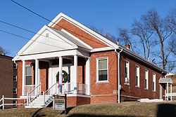
Ellsworth, Pennsylvania Borough Building.jpg
Borough Building in 2015
Washington County Pennsylvania Incorporated and Unincorporated areas Ellsworth Highlighted.svg
Location of Ellsworth in Washington County, Pennsylvania.
USA Pennsylvania location map.svg
Red pog.svg
Ellsworth
Location of Ellsworth in Pennsylvania
Coordinates: 40°6′21″N80°1′14″W / 40.10583°N 80.02056°W / 40.10583; -80.02056
CountryUnited States
State Pennsylvania
County Washington
Established1900
Government
  MayorJoseph Daniel Kudlac
Area
[1]
  Total0.76 sq mi (1.96 km2)
  Land0.74 sq mi (1.91 km2)
  Water0.02 sq mi (0.04 km2)
Population
 (2020) [2]
  Total945
  Density1,278.76/sq mi (493.65/km2)
Time zone UTC-4 (EST)
  Summer (DST) UTC-5 (EDT)
ZIP code
15331 [3]
Area code 724

Ellsworth is a borough in Washington County, Pennsylvania, United States. The population was 947 at the 2020 census. [4] The coal town was founded by James Ellsworth, who bought the land in 1890s, developed the Monongahela Railway, and sold the mines to Bethlehem Steel in the 1920s. [5]

Contents

Geography

Ellsworth is located at 40°6′21″N80°1′14″W / 40.10583°N 80.02056°W / 40.10583; -80.02056 (40.105887, -80.020455). [6]

According to the United States Census Bureau, the borough has a total area of 0.8 square miles (2.1 km2), of which 0.7 square miles (1.8 km2) is land and 0.04 square miles (0.10 km2) (2.63%) is water.

Demographics

Historical population
CensusPop.Note
1910 2,084
1920 2,82835.7%
1930 2,274−19.6%
1940 1,974−13.2%
1950 1,670−15.4%
1960 1,456−12.8%
1970 1,268−12.9%
1980 1,228−3.2%
1990 1,048−14.7%
2000 1,0833.3%
2010 1,027−5.2%
2020 947−7.8%
2021 (est.)939 [4] −0.8%
Sources: [7] [8] [9] [2]

At the 2000 census there were 1,083 people, 484 households, and 291 families living in the borough. The population density was 1,467.7 people per square mile (566.7 people/km2). There were 528 housing units at an average density of 715.6 per square mile (276.3/km2). The racial makeup of the borough was 96.03% White, 2.31% African American, 0.09% Asian, 0.09% from other races, and 1.48% from two or more races. Hispanic or Latino of any race were 0.65%. [8]

Of the 484 households 23.8% had children under the age of 18 living with them, 44.8% were married couples living together, 12.2% had a female householder with no husband present, and 39.7% were non-families. 36.8% of households were one person and 20.7% were one person aged 65 or older. The average household size was 2.22 and the average family size was 2.91.

The age distribution was 20.6% under the age of 18, 7.8% from 18 to 24, 26.6% from 25 to 44, 24.0% from 45 to 64, and 21.0% 65 or older. The median age was 41 years. For every 100 females there were 92.4 males. For every 100 females age 18 and over, there were 88.6 males.

The median household income was $31,477 and the median family income was $40,385. Males had a median income of $35,764 versus $20,221 for females. The per capita income for the borough was $17,159. About 5.5% of families and 9.4% of the population were below the poverty line, including 6.3% of those under age 18 and 14.7% of those age 65 or over.

Related Research Articles

<span class="mw-page-title-main">Ellsworth, Michigan</span> Village in Michigan, United States

Ellsworth is a village in Antrim County in the U.S. state of Michigan. The population was 349 at the 2010 census. The village is located within Banks Township.

<span class="mw-page-title-main">Emsworth, Pennsylvania</span> Borough in Allegheny County, Pennsylvania, United States

Emsworth is a borough in Allegheny County, Pennsylvania, United States, along the Ohio River. The population was 2,525 at the 2020 census.

<span class="mw-page-title-main">Leetsdale, Pennsylvania</span> Borough in Allegheny county, Pennsylvania

Leetsdale is a borough in Allegheny County, Pennsylvania, along the Ohio River. It is part of the Pittsburgh Metro Area. The population was 1,162 at the 2020 census.

<span class="mw-page-title-main">West Kittanning, Pennsylvania</span> Borough in Pennsylvania, United States

West Kittanning is a borough in Armstrong County, Pennsylvania, United States. The population was 1,192 at the 2020 census.

<span class="mw-page-title-main">Bridgewater, Pennsylvania</span> Borough in Pennsylvania, United States

Bridgewater is a borough in central Beaver County, Pennsylvania, United States, at the confluence of the Beaver and Ohio rivers. The population was 744 at the 2020 census. It is part of the Pittsburgh metropolitan area. The borough is best known as the home of the Bruster's Ice Cream chain. A few scenes in the 1986 movie Gung Ho were also shot in Bridgewater. Much of Bridgewater, including its two major streets, are included in the Bridgewater Historic District.

<span class="mw-page-title-main">Economy, Pennsylvania</span> Borough in Pennsylvania, United States

Economy is a borough in Beaver County, Pennsylvania, United States. The population was 9,079 at the 2020 census. It is a part of the Pittsburgh metropolitan area.

<span class="mw-page-title-main">Glasgow, Pennsylvania</span> Borough in Pennsylvania, United States

Glasgow is a borough in Beaver County, Pennsylvania, United States, along the Ohio River. The population was 71 at the 2020 census.

<span class="mw-page-title-main">Connoquenessing, Pennsylvania</span> Borough in Pennsylvania, United States

Connoquenessing is a borough in Butler County, Pennsylvania, United States. The population was 528 at the 2010 census.

<span class="mw-page-title-main">Seven Fields, Pennsylvania</span> Place in Pennsylvania, United States

Seven Fields is a borough in Butler County, Pennsylvania, United States. The population was 2,887 at the 2010 census, an increase from the figure of 1,986 tabulated in 2000.

<span class="mw-page-title-main">South Fork, Pennsylvania</span> Borough in Pennsylvania, United States

South Fork is a borough in Cambria County, Pennsylvania, United States. It is part of the Johnstown, Pennsylvania Metropolitan Statistical Area. The population was 928 at the 2010 census, down from 1,138 at the 2000 census.

<span class="mw-page-title-main">Hawthorn, Pennsylvania</span> Borough in Pennsylvania, United States

Hawthorn is a borough in Clarion County, Pennsylvania, United States. The population was 482 at the 2020 census.

<span class="mw-page-title-main">Bessemer, Lawrence County, Pennsylvania</span> Borough in Pennsylvania, United States

Bessemer is a borough in western Lawrence County, Pennsylvania, United States. The population was 1,073 at the 2020 census. It is part of the Pittsburgh metropolitan area.

<span class="mw-page-title-main">Sandy Lake, Pennsylvania</span> Borough in Pennsylvania, United States

Sandy Lake is a borough in eastern Mercer County, Pennsylvania, United States. It was established in 1849. The population was 649 at the 2020 census. It is part of the Hermitage micropolitan area.

<span class="mw-page-title-main">Lanesboro, Pennsylvania</span> Borough in Pennsylvania, United States

Lanesboro is a borough in Susquehanna County, Pennsylvania, United States. The population was 485 at the 2020 census.

<span class="mw-page-title-main">Beallsville, Pennsylvania</span> Borough in Pennsylvania, United States

Beallsville is a borough in Washington County, Pennsylvania, United States and part of the Pittsburgh metropolitan area since 1950. The population was 392 at the 2020 census. Much of the borough has been designated the Beallsville Historic District.

<span class="mw-page-title-main">Deemston, Pennsylvania</span> Borough in Pennsylvania, United States

Deemston is a borough in Washington County, Pennsylvania, United States and part of the Pittsburgh metropolitan area since 1950. The population was 751 at the 2020 census.

<span class="mw-page-title-main">North Bethlehem Township, Pennsylvania</span> Township in Pennsylvania, United States

North Bethlehem Township is a township in Washington County, Pennsylvania, United States. The population was 1,548 at the 2020 census. The residents of the township are part of the Bentworth School District with schools located in nearby Bentleyville and Ellsworth boroughs.

<span class="mw-page-title-main">West Middletown, Pennsylvania</span> Borough in Pennsylvania, United States

West Middletown is a borough in Washington County, Pennsylvania, United States. The population was 109 at the 2020 census.

<span class="mw-page-title-main">Cathcart, Washington</span> CDP in Washington, United States

Cathcart is a census-designated place (CDP) in Snohomish County, Washington, United States. The population was 2,458 at the 2010 census. Based on per capita income, one of the more reliable measures of affluence, Cathcart ranks 45th of 522 areas in the state of Washington to be ranked. Cathcart was named for Isaac Cathcart, a lumberman, entrepreneur, and Snohomish County pioneer.

<span class="mw-page-title-main">Ellwood City, Pennsylvania</span> Borough in Pennsylvania, United States

Ellwood City is a borough primarily in Lawrence County, Pennsylvania, United States. With a small district extending into Beaver County, it lies along the Connoquenessing Creek just east of its confluence with the Beaver River. The population was 7,642 at the 2020 census. Ellwood City lies 30 miles (48 km) northwest of Pittsburgh and 8 miles (13 km) southeast of New Castle within the Pittsburgh metropolitan area.

References

  1. "ArcGIS REST Services Directory". United States Census Bureau. Retrieved October 12, 2022.
  2. 1 2 "Census Population API". United States Census Bureau. Retrieved Oct 12, 2022.
  3. "Ellsworth PA ZIP Code". zipdatamaps.com. 2023. Retrieved October 31, 2023.
  4. 1 2 Bureau, US Census. "City and Town Population Totals: 2020-2021". Census.gov. US Census Bureau. Retrieved 22 July 2022.
  5. "Founder of Ellsworth (James W. Ellsworth) Dies at Florence, Italy". The Daily Republican. 4 June 1925. p. 1.
  6. "US Gazetteer files: 2010, 2000, and 1990". United States Census Bureau. 2011-02-12. Retrieved 2011-04-23.
  7. "Census of Population and Housing". U.S. Census Bureau. Retrieved 11 December 2013.
  8. 1 2 "U.S. Census website". United States Census Bureau. Retrieved 2008-01-31.
  9. "Incorporated Places and Minor Civil Divisions Datasets: Subcounty Resident Population Estimates: April 1, 2010 to July 1, 2012". Population Estimates. U.S. Census Bureau. Archived from the original on 11 June 2013. Retrieved 11 December 2013.