
Bethel Park is a borough with home rule status in Allegheny County, Pennsylvania, United States. It is a suburb within the Pittsburgh metropolitan area, located approximately 7 miles (11 km) south of Pittsburgh. The population was 33,577 as of the 2020 census.

South Fayette Township is a township in Allegheny County, Pennsylvania, United States. The population was 14,416 at the 2010 census.

Roaring Spring is a borough in Blair County, Pennsylvania, United States. The population was 2,392 at the 2020 census. It is part of the Altoona, PA Metropolitan Statistical Area

Summerhill is a borough in Cambria County, Pennsylvania, United States. The population was 490 at the 2010 census.

The history of Pittsburgh began with centuries of Native American civilization in the modern Pittsburgh region, known as Jaödeogë’ in the Seneca language. Eventually, European explorers encountered the strategic confluence where the Allegheny and Monongahela Rivers meet to form the Ohio, which leads to the Mississippi River. The area became a battleground when France and Great Britain fought for control in the 1750s. When the British were victorious, the French ceded control of territories east of the Mississippi.

Guilford is an unincorporated community located in Howard County in the state of Maryland. The location is named after the Guilford Mill. Guilford is near Kings Contrivance, one of the nine "villages" of Columbia.
Hooks Mills is an unincorporated community in Hampshire County, West Virginia, United States. It is located on Hooks Mill Road which intersects Cacapon River Road 4.5 miles south of Capon Bridge. Hooks Mills is named for the saw and grist mill on the Cacapon River run by the Hook family from 1848 to the late 1930s.

A large metropolitan area that is surrounded by rivers and hills, Pittsburgh has an infrastructure system that has been built out over the years to include roads, tunnels, bridges, railroads, inclines, bike paths, and stairways; however, the hills and rivers still form many barriers to transportation within the city.
Dutch Neck is an unincorporated community located within West Windsor Township in Mercer County, in the U.S. state of New Jersey. The community is centered about the intersection of Village Road East, Village Road West, and South Mill Road and has in the vicinity several churches, the West Windsor Volunteer Fire Company No. 1, Dutch Neck Elementary School, and many residences.

Norbeck is the area of Montgomery County, Maryland, United States, around Norbeck Road east of Georgia Avenue to Layhill Road. Shortly before the Civil War, free blacks founded Norbeck.

The economy of Pittsburgh, Pennsylvania is diversified, focused on services, medicine, higher education, tourism, banking, corporate headquarters and high technology. Once the center of the American steel industry, and still known as "The Steel City", today the city of Pittsburgh has no steel mills within its limits, though Pittsburgh-based companies such as US Steel, Ampco Pittsburgh and Allegheny Technologies own several working mills in the Pittsburgh metropolitan area.

Chatham Village is a community within the larger Mount Washington neighborhood of the city of Pittsburgh, Pennsylvania, and an internationally acclaimed model of community design. It is roughly bounded by Virginia Avenue, Bigham Street, Woodruff Street, Saw Mill Run Boulevard, and Olympia Road, and was declared a National Historic Landmark in 2005 as a remarkably well-preserved example of Garden City Movement design.

Orlando is an unincorporated community located in Braxton and Lewis counties, West Virginia, United States. It is located on Oil Creek, a tributary of the Little Kanawha River.

Double Bayou is an unincorporated community in Chambers County, Texas, United States. According to the Handbook of Texas, the community had a population of 400 in 2000. It is located within the Greater Houston metropolitan area.
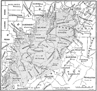
The Pittsburgh coal seam is the thickest and most extensive coal bed in the Appalachian Basin; hence, it is the most economically important coal bed in the eastern United States. The Upper Pennsylvanian Pittsburgh coal bed of the Monongahela Group is extensive and continuous, extending over 11,000 mi2 through 53 counties. It extends from Allegany County, Maryland to Belmont County, Ohio and from Allegheny County, Pennsylvania southwest to Putnam County, West Virginia.
Richardson is an unincorporated community in Calhoun County, West Virginia, United States.

Chelsea is an unincorporated community in Bethel Township in Delaware County, Pennsylvania, United States. Chelsea is located at the intersection of Concord Road, Chelsea Road, Foulk Road, and Valley Brook Road in the northern part of the township.

The Washington oil field is an oil field and in Washington County, Pennsylvania. It also produced natural gas.

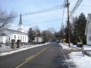
Craigsville is an unincorporated community in West Franklin Township Armstrong County, Pennsylvania, United States. The community is 7.1 miles (11.4 km) west-northwest of the county seat, Kittanning.

The Colonial Industrial Quarter in Bethlehem, Pennsylvania is considered America's earliest industrial park. Established by the colonial Moravians along the banks of the Monocacy Creek, the ten-acre site contains historic buildings such as the 1762 Waterworks, 1761 Tannery, 1869 Luckenbach Mill, 1748/1834 Gristmiller's House, reconstructed 1764Springhouse and 1750Smithy, as well as ruins of the original 1749Pottery, 1752Butchery, 1765Oil Mill, and 1771 Dye House. This location was chosen to take advantage of a spring that supplied potable water and the power supplied by the Monocacy Creek's flow for the craftsmen and trades of early Bethlehem.


