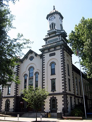
Northumberland County is a county in the Commonwealth of Pennsylvania. As of the 2020 census, the population was 91,647. Its county seat is Sunbury. The county is part of the Central Pennsylvania region of the state.

Montour County is a county in the Commonwealth of Pennsylvania. As of the 2020 census, the population was 18,136. Its county seat is Danville. The county is named for Andrew Montour, a prominent Métis interpreter who served with George Washington during the French and Indian War. It encompasses 132 sq mi, making it the smallest county by land area in the state. The county is part of the Central Pennsylvania region of the state.
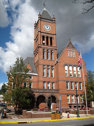
Columbia County is a county in the Commonwealth of Pennsylvania. It is located in Northeastern Pennsylvania. As of the 2020 census, the population was 64,727. Its county seat is Bloomsburg. The county was created on March 22, 1813, from part of Northumberland County. It was named Columbia, alluding to the United States and Christopher Columbus. The county is part of the Central Pennsylvania region of the state.
Coraopolis is a borough in Allegheny County, Pennsylvania, United States, along the Ohio River. The population was 5,559 at the 2020 census.

Fayette City is a borough in Fayette County, Pennsylvania, United States. The population was 502 at the 2020 census, a decline from the figure of 596 tabulated in 2010. It is served by the Belle Vernon Area School District. Some buildings in the town antedate 1820.

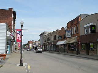
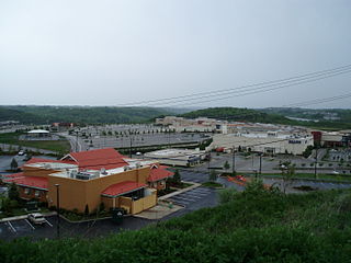
Danville is a borough in and the county seat of Montour County, Pennsylvania, United States, along the North Branch of the Susquehanna River. The population was 4,221 at the 2020 census. Danville is part of the Bloomsburg-Berwick micropolitan area.
Coaldale is a borough in Schuylkill County, Pennsylvania, United States. Initially settled in 1827, it was incorporated in 1906 from part of the former Rahn Township; it is named for the coal industry—wherein, it was one of the principal early mining centers. Coaldale is in the southern Anthracite Coal region in the Panther Creek Valley, a tributary of the Little Schuylkill River, along which U.S. Route 209 was eventually built between the steep climb up Pisgah Mountain from Nesquehoning (easterly) and its outlet in Tamaqua, approximately five miles to the west.

Marianna is a borough in Washington County, Pennsylvania, United States. The population was 399 at the 2020 census.

Mount Pleasant Township is a township in Washington County, Pennsylvania, United States. As of the 2020 census, the township population was 3,282.
Robinson Township is a township in Allegheny County, Pennsylvania, United States, approximately 12 miles (19 km) west of Pittsburgh. The population was 15,503 at the 2020 census. Home to Robinson Town Centre, Settlers Ridge and The Mall at Robinson, the township serves as a retail hub for the Pittsburgh metropolitan area.

The Montour Railroad was a short line railroad company operating passenger and freight service in southwestern Pennsylvania. At its height in the 1930s, the railroad served 27 mines transporting nearly seven million tons of coal annually in Allegheny and Washington Counties.

Imperial is a census-designated place (CDP) in Allegheny County, Pennsylvania, United States and part of the Pittsburgh metropolitan area. The population was 2,722 at the 2020 census. The CDP is located in North Fayette and Findlay Townships, and geographically close to Pittsburgh International Airport.
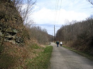
The Montour Trail is a multi-use recreational rail trail near Pittsburgh, Pennsylvania. It was formerly the Montour Railroad.
The Pittsburgh Terminal Coal Company was a bituminous coal mining company based in Pittsburgh and controlled by the Mellon family. It operated mines in the Pittsburgh Coalfield, including mines in Becks Run and Horning, Pennsylvania. Unusually for that time in Pennsylvania, it hired African-American miners for some of its work.
The Naomi Mine explosion occurred on December 1, 1907, in the Naomi Mine, approximately 2 miles (3.2 km) from Fayette City, Pennsylvania. The incident resulted in the deaths of at least 35 miners and left no survivors.
The panhandle coalfield is a coalfield located in the northern panhandle of West Virginia counties of Hancock, Brooke, Ohio, Marshall, and Wetzel. Mining is primarily in the Pittsburgh coal seam, sometimes called the No. 8 seam, which is of a steam rather than metallurgical nature in this region. Currently CONSOL Energy maintains two large mines in this field - Shoemaker and McElroy. Also, the first new mine in Ohio County in forty years was being developed on Short Creek by Alliance Coal Co. in 2009.
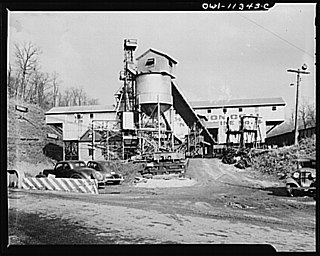
McAdams is an unincorporated community in Robinson Township, Washington County, Pennsylvania, United States. McAdams is located at the intersection of Pennsylvania Route 980 and North Branch Road, 2.2 miles (3.5 km) west-northwest of McDonald. The community is a coal town which was the site of the Pittsburgh Coal Company's Montour No. 9 mine, which closed in 1954. The Montour Trail passes through the community, as did a branch of the Montour Railroad during the mine's operation.
Cross Creek is a census-designated place located in Cross Creek Township, Washington County in the state of Pennsylvania. The community is located in northern Washington County about 2 miles southwest of the community of Atlasburg. As of the 2010 census the population was 137 residents.
Lawrence is a census-designated place located in Cecil Township, Washington County in the state of Pennsylvania. The community is a Pittsburgh suburb located in northern Washington County near the Allegheny County line. As of the 2010 census the population was 540 residents.

Buck Mountain is a mountain in Columbia County and Luzerne County, Pennsylvania, in the United States. Its elevation is 1,942 feet (592 m) above sea level. The mountain contains deposits of coal. Shale and conglomerate are also present. The coal on the mountain was historically mined, altering the landscape somewhat. It is most likely named after Albert Ansbach.

