Mount Pleasant Township, Washington County, Pennsylvania

Last updated

Mount Pleasant Township, Pennsylvania
Mount Pleasant Township, Washington County, Pennsylvania.jpg
Looking west near 78 Main Street in Hickory
Map of Mount Pleasant Township, Washington County, Pennsylvania Highlighted.png
Location of Mount Pleasant Township in Washington County
Map of Pennsylvania highlighting Washington County.svg
Location of Washington County in Pennsylvania
CountryUnited States
State Pennsylvania
County Washington
EstablishedMay 10, 1788
Area
[1]
  Total35.67 sq mi (92.39 km2)
  Land35.59 sq mi (92.18 km2)
  Water0.08 sq mi (0.21 km2)
Population
 (2020) [2]
  Total3,282 Decrease2.svg
  Estimate 
(2021) [2]
3,299
  Density98.34/sq mi (37.97/km2)
Time zone UTC-5 (EST)
  Summer (DST) UTC-4 (EDT)
Area code 724
Website www.mpt-pa.com
Historical population
CensusPop.Note
2000 3,422
2010 3,5152.7%
2020 3,282−6.6%
2021 (est.)3,299 [2] 0.5%
U.S. Decennial Census [3]

Mount Pleasant Township is a township in Washington County, Pennsylvania, United States. As of the 2020 census, the township population was 3,282. [2]

Contents

History

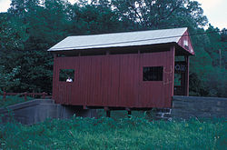
Krepps Covered Bridge KREPPS COVERED BRIDGE.jpg
Krepps Covered Bridge

The Krepps Covered Bridge was listed on the National Register of Historic Places in 1979. [4]

Geography

According to the United States Census Bureau, the township has a total area of 35.7 square miles (92 km2), of which 35.6 square miles (92 km2) is land and 0.1 square miles (0.26 km2) (0.22%) is water.

Transportation

Rail

McGugin Tunnel

The McGugin Tunnel is located at latitude - longitude coordinates of N 40.28674 and W -80.33173. The nearest major town is Hickory, Pennsylvania, where it passes under Pennsylvania Route 18. The tunnel is at an elevation of 1,263 feet (385 m).

Hickory Tunnel

The Hickory Tunnel is close to the McGugin Tunnel. It has the same nearest major town, Hickory, where the tunnel passes under Pennsylvania Route 50. The elevation of the tunnel is 1,286 feet (392 m).

Several major roads pass through the township of Mount Pleasant: Pennsylvania Route 519, Pennsylvania Route 50, and Pennsylvania Route 18.

Demographics

As of the census [5] of 2000, there were 3,422 people, 1,279 households, and 1,006 families residing in the township.

The population density was 96.0 people per square mile (37.1 people/km2). There were 1,348 housing units at an average density of 37.8 per square mile (14.6/km2).

The racial makeup of the township was 96.49% White, 2.98% African American, 0.09% Asian, and 0.44% from two or more races. Hispanic or Latino of any race were 0.09% of the population.

There were 1,279 households, out of which 32.5% had children under the age of eighteen living with them; 66.1% were married couples living together, 9.0% had a female householder with no husband present, and 21.3% were non-families. 18.9% of all households were made up of individuals, and 9.8% had someone living alone who was sixty-five years of age or older.

The average household size was 2.67 and the average family size was 3.06.

In the township the population was spread out, with 24.0% under the age of eighteen, 7.1% from eighteen to twenty-four, 27.7% from twenty-five to forty-four, 25.7% from forty-five to sixty-four, and 15.6% who were sixty-five years of age or older. The median age was forty years.

For every one hundred females, there were one hundred males. For every one hundred females who were aged eighteen or older, there were 98.9 males.

The median income for a household in the township was $41,172, and the median income for a family was $48,915. Males had a median income of $35,750 compared with that of $22,917 for females.

The per capita income for the township was $18,800.

Roughly 3.6% of families and 5.3% of the population were living below the poverty line, including 5.9% of those who were under the age of eighteen and 7.9% of those who were aged sixty-five or older.

Mount Pleasant Township is home to four small communities: Hickory, Southview, the Cherry Valley Lakeview Estates and Primrose. It is also home to the Fort Cherry School District.

Related Research Articles

<span class="mw-page-title-main">Mount Pleasant Township, Adams County, Pennsylvania</span> Township in Pennsylvania, United States

Mount Pleasant Township is a township that is located in Adams County, Pennsylvania, United States. As of the 2010 census, the township population was 4,693.

<span class="mw-page-title-main">Plumcreek Township, Pennsylvania</span> Township in Pennsylvania, United States

Plumcreek Township is a township that is located in Armstrong County, Pennsylvania, United States. The population was 2,106 at the time of the 2020 census, a decrease from the figure of 2,375 that was tabulated in 2010.

<span class="mw-page-title-main">Hookstown, Pennsylvania</span> Borough in Pennsylvania, United States

Hookstown is a borough in western Beaver County, Pennsylvania, United States. The population was 129 at the time of the 2020 census. It is part of the Pittsburgh metropolitan area.

<span class="mw-page-title-main">Worth Township, Butler County, Pennsylvania</span> Township in Pennsylvania, United States

Worth Township is a township that is located in Butler County, Pennsylvania, United States. The population was 1,398 at the time of the 2020 census.

<span class="mw-page-title-main">Middle Taylor Township, Pennsylvania</span> Township in Pennsylvania, United States

Middle Taylor Township is a township that is located in Cambria County, Pennsylvania, United States. The population was 727 at thee of the 2010 census. It is part of the Johnstown, Pennsylvania Metropolitan Statistical Area.

<span class="mw-page-title-main">Penn Township, Chester County, Pennsylvania</span> Township in Pennsylvania, United States

Penn Township is a township that is located in Chester County, Pennsylvania, United States. It is home to the Nursery Capital of Pennsylvania and was the site of Sunset Park, one of country music's most popular venues.

<span class="mw-page-title-main">Upper Oxford Township, Pennsylvania</span> Township in Pennsylvania, United States

Upper Oxford Township is a township that is located in Chester County, Pennsylvania, United States. As of the 2010 census, the township had a population of 2,484.

<span class="mw-page-title-main">Limestone Township, Clarion County, Pennsylvania</span> Township in Pennsylvania, United States

Limestone Township is a township that is located in Clarion County, Pennsylvania, United States. The population was 1,870 at the time of the 2020 census, an increase from the figure of 1,858 tabulated in 2010.

<span class="mw-page-title-main">Huston Township, Clearfield County, Pennsylvania</span> Township in Pennsylvania, United States

Huston Township is an American township which is located in Clearfield County, Pennsylvania. The population was 1,264 at the time of the 2020 census.

<span class="mw-page-title-main">Lamar Township, Pennsylvania</span> Township in Pennsylvania, United States

Lamar Township is an American township that is located in Clinton County, Pennsylvania. The population was 2,600 at the time of the 2020 census.

<span class="mw-page-title-main">Pine Township, Columbia County, Pennsylvania</span> Township in Pennsylvania, United States

Pine Township is a township in Columbia County, Pennsylvania. It is part of Northeastern Pennsylvania. The population was 1,014 at the time of the 2020 census.

<span class="mw-page-title-main">Hickory Township, Forest County, Pennsylvania</span> Township in Pennsylvania, United States

Hickory Township is a township in Forest County, Pennsylvania, United States. As of the 2020 census, the township population was 416, a decline from 558 in 2010.

<span class="mw-page-title-main">Letterkenny Township, Pennsylvania</span> Township in Pennsylvania, United States

Letterkenny Township is a township that is located in Franklin County, Pennsylvania, United States. The population was 2,462 at the time of the 2020 census, up from 2,074 at the 2000 census.

<span class="mw-page-title-main">Whiteley Township, Pennsylvania</span> Township in Pennsylvania, United States

Whiteley Township is a township that is located in Greene County, Pennsylvania, United States. The population was 569 at the time of the 2020 census, which was a decreased from the total of 649 that was documented during the 2010 census.

<span class="mw-page-title-main">Lincoln Township, Huntingdon County, Pennsylvania</span> Township in Pennsylvania, United States

Lincoln Township is a township that is located in Huntingdon County, Pennsylvania, United States. The population was 321 at the time of the 2020 census.

<span class="mw-page-title-main">Rapho Township, Pennsylvania</span> Township in Pennsylvania, United States

Rapho Township is a township that is located in northwestern Lancaster County, Pennsylvania, United States. The population was 12,058 at the time of the 2020 census.

<span class="mw-page-title-main">Mount Carmel Township, Pennsylvania</span> Township in Pennsylvania, United States

Mount Carmel Township is a township that is located in Northumberland County, Pennsylvania in the United States. The population at the time of the 2010 Census was 3,139, which was an increase over the figure of 2,701 that was tabulated during the 2000.

<span class="mw-page-title-main">North Manheim Township, Pennsylvania</span> Township in Pennsylvania, United States

North Manheim Township is a township that is located in Schuylkill County, Pennsylvania, United States. The population was 4,043 at the time of the 2020 census.

<span class="mw-page-title-main">Norwegian Township, Pennsylvania</span> Township in Pennsylvania, United States

Norwegian Township is a township that is located in Schuylkill County, Pennsylvania, United States. The population was 2,167 at the time of the 2020 census.

<span class="mw-page-title-main">Pine Grove Township, Schuylkill County, Pennsylvania</span> Township in Pennsylvania, United States

Pine Grove Township is a township that is located in Schuylkill County, Pennsylvania, United States. The population was 4,024 at the time of the 2020 census.

References

  1. "2016 U.S. Gazetteer Files". United States Census Bureau. Retrieved August 14, 2017.
  2. 1 2 3 4 Bureau, US Census. "City and Town Population Totals: 2020-2021". Census.gov. US Census Bureau. Retrieved July 21, 2022.
  3. "Census of Population and Housing". Census.gov. Retrieved June 4, 2016.
  4. "National Register Information System". National Register of Historic Places . National Park Service. July 9, 2010.
  5. "U.S. Census website". United States Census Bureau . Retrieved January 31, 2008.

40°19′59″N80°17′59″W / 40.333°N 80.2997°W / 40.333; -80.2997