Related Research Articles

Redwood Estates is a rural unincorporated community along State Route 17 in the coastal Santa Cruz Mountains in Los Gatos, California, United States. The Census Bureau includes it in a census-designated place named Lexington Hills. It lies inside the confines of Santa Clara County. The area is about eight miles from downtown Los Gatos and nine miles from the Santa Cruz County community of Scotts Valley.
Kersey is an unincorporated community in Wheatfield Township, Jasper County, Indiana, United States.
Aziak Island is a small island in the Andreanof Islands group in the Aleutian Islands of southwestern Alaska. The name "Aziak" is derived from the Aleut word ha-azax - "ten," and in many books and charts published before 1920, it was often used to refer to Sledge Island, located 930 miles (1,500 km) to the northeast off the Seward Peninsula, or to a native settlement on that island. This practice apparently became rarer as the twentieth century progressed and today Aziak is used almost exclusively to refer the Andreanof-group island. Aziak Island is approximately 1.1 miles (1.8 km) long and reaches a maximum elevation of 190 feet (58 m). Very little is known about the island and it is uninhabited.
Tenmile is an unincorporated community in Douglas County, Oregon, United States. It is located on Oregon Route 42 southwest of Roseburg.
Rodney Mountain is located in Pushmataha County, Oklahoma, approximately five miles northwest of Antlers, Oklahoma. It is a part of the Kiamichi Mountains, a subrange of the Ouachita Mountains, and forms its southwest-most extremity. Its summit is 767 feet above sea level. It is found at GPS coordinates 34.2984336 and −95.6410833.
Jumbo is an unincorporated community in western Pushmataha County, Oklahoma, United States, 10 miles north of Miller.
Miller is an unincorporated community in southwestern Pushmataha County, Oklahoma, United States, 10 miles northwest of Antlers and a short distance west of Moyers.
Brown is an unincorporated community in Harrison County, in the U.S. state of West Virginia.
Dickeyville is an unincorporated community in Owen Township, Warrick County, in the U.S. state of Indiana.

Tenmile Creek is a tributary stream of Little Seneca Creek in Montgomery County, Maryland.
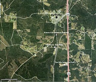
Ten Mile, also known as Tenmile, is an unincorporated community in Stone County, Mississippi, located approximately 1.15 mi (1.85 km) south of Perkinston. Ten Mile is part of the Gulfport-Biloxi metropolitan area. The main period of significance was between 1904 and 1923.
Dorninton is an unincorporated community in Putnam County, in the U.S. state of Ohio.
Red Haw is an unincorporated community in Ashland County, in the U.S. state of Ohio.
Butts is an unincorporated community in eastern Crawford County, in the U.S. state of Missouri. The community is on the north side of Henpeck Hollow about one-half mile east of Courtois Creek. Access is via a county road from Missouri Route 8, approximately five miles east of Elayer. The location is within the Mark Twain National Forest and a campground is located on the Courtois River to the west of the site.
Milltown is an unincorporated community in western Butler County, Missouri, United States. Milltown is located on Hurricane Creek, approximately two miles west of its confluence with Tenmile Creek. It lies within the Mark Twain National Forest, about ten miles west of Poplar Bluff.
Husband is an unincorporated community in Somerset County, Pennsylvania.
Tenmile Creek is a stream in Washington and Greene Counties, Pennsylvania, USA. It is a tributary of the Monongahela River.
Cycle is an unincorporated community in Yadkin County, North Carolina, United States.
Far is an unincorporated community in Wetzel County, West Virginia, United States.
The Stanley Shale, or Stanley Group, is a Mississippian stratigraphic unit in the Ouachita Mountains of Arkansas and Oklahoma. First described in Arkansas in 1892, this unit was not named until 1902 by J.A. Taff in his study of the Ouachita Mountains of Oklahoma. Taff assigned the town of Stanley in Pushmataha County, Oklahoma as the type locality, but did not designate a stratotype. After introduction into Arkansas in 1909 by Albert Homer Purdue, the unit was redefined in 1918, when the formation known as the Fork Mountain Slate was abandoned and partially combined into the Stanley Shale. As of 2017, a reference section for the Stanley Shale has yet to be designated.
References
- 1 2 U.S. Geological Survey Geographic Names Information System: Ten Mile
- ↑ "Post Offices". Jim Forte Postal History. Retrieved 5 January 2017.
- ↑ Moyer, Armond; Moyer, Winifred (1958). The origins of unusual place-names. Keystone Pub. Associates. p. 128.

Coordinates: 40°01′14″N80°09′23″W / 40.02056°N 80.15639°W
| | This Washington County, Pennsylvania state location article is a stub. You can help Wikipedia by expanding it. |