Lucky Peak Lake

Last updated
Lucky Peak Reservoir
Lucky peak.jpg
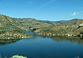
Lucky Peak Reservoir in April 2010
USA Idaho relief location map.svg
Red pog.svg
Lucky Peak Reservoir
Usa edcp relief location map.png
Red pog.svg
Lucky Peak Reservoir
Location Ada / Boise / Elmore counties, Idaho, United States
Coordinates 43°31′31″N116°2′36″W / 43.52528°N 116.04333°W / 43.52528; -116.04333 Coordinates: 43°31′31″N116°2′36″W / 43.52528°N 116.04333°W / 43.52528; -116.04333
Type reservoir
Primary inflows Boise River
Primary outflows Boise River
Catchment area 2,680 sq mi (6,940 km2) [1]
Basin  countriesUnited States
Built1955 (1955), Lucky Peak Dam
Surface area2,820 acres (11.4 km2) [1]
Water volume307,000 acre⋅ft (0.379 km3) [1]
Surface elevation3,050 ft (930 m) AMSL

Lucky Peak Reservoir (also known as Lucky Peak Lake [2] ) is a reservoir on the Boise River in the U.S. state of Idaho. It is located mainly in Ada County, extending into Boise County and Elmore County. It was created in 1955 with the construction of Lucky Peak Dam. [1] Lucky Peak State Park surrounds part of the lake.

Contents

See also

Related Research Articles

Boise River

The Boise River is a 102-mile-long (164 km) tributary of the Snake River in the Northwestern United States. It drains a rugged portion of the Sawtooth Range in southwestern Idaho northeast of Boise, as well as part of the western Snake River Plain. The watershed encompasses approximately 4,100 square miles (11,000 km2) of highly diverse habitats, including alpine canyons, forest, rangeland, agricultural lands, and urban areas.

Treasure Valley Metropolitan area and river valley in southwestern Idaho

The Treasure Valley is a valley in the western United States, primarily in southwestern Idaho, where the Payette, Boise, Weiser, Malheur, Owyhee, and Burnt rivers drain into the Snake River. It includes all the lowland areas from Vale in rural eastern Oregon to Boise, and is the most populated area in Idaho.

Boise National Forest National forest in the US state of Idaho

Boise National Forest is a National Forest covering 2,203,703 acres (8,918.07 km2) of the U.S. state of Idaho. Created on July 1, 1908, from part of Sawtooth National Forest, it is managed by the U.S. Forest Service as five units: the Cascade, Emmett, Idaho City, Lowman, and Mountain Home ranger districts.

American Falls Dam Dam in Idaho, U.S.

The American Falls Dam is a concrete gravity-type dam located near the town of American Falls, Idaho, on river mile 714.7 of the Snake River. The dam and reservoir are a part of the Minidoka Project on the Snake River Plain and are used primarily for flood control, irrigation, and recreation. When the original dam was built by the Bureau of Reclamation, the residents of American Falls were forced to relocate three-quarters of their town to make room for the reservoir. A second dam was completed in 1978 and the original structure was demolished. Although the dam itself is located in Power County, its reservoir also stretches northeastward into both Bingham County and Bannock County.

Deer Flat National Wildlife Refuge

The Deer Flat National Wildlife Refuge is an important breeding area for mammals, birds, and other animals. The National Wildlife Refuge is located on land surrounding Lake Lowell, just outside Nampa, Idaho. It serves as a resting and wintering area for birds, including mallards and Canada geese, along the Pacific Flyway and was named a "Globally Important Bird Area" by the American Bird Conservancy.

Lake Cascade Dam in Valley County, Idaho

Lake Cascade (formerly Cascade Reservoir, is a reservoir in the western United States, on the North Fork of the Payette River in Valley County, Idaho. Located in the Boise National Forest, it has a surface area of 47 square miles, and is the fourth largest lake or reservoir in the state. The closest cities are Cascade, Donnelly, and McCall, all in the Long Valley of Valley County.

Deadwood Reservoir

Deadwood Reservoir is a reservoir in the western United States, in Valley County, Idaho. Located in the mountains of the Boise National Forest about 25 miles (40 km) southeast of Cascade, the 3,000-acre (12 km2) body on the Deadwood River is created by Deadwood Dam. The river flow south from the dam and is a tributary of the South Fork of the Payette River. The reservoir and vicinity is commonly used for camping, water skiing, fishing, canoeing, and other outdoor recreation. The full pool surface elevation is just above a mile-high at 5,334 ft (1,626 m) above sea level.

Lucky Peak Dam Dam in Ada County, Idaho

Lucky Peak Dam is a rolled earth and gravel fill embankment dam in the western United States, located on the Boise River in Ada County, Idaho. It is directly downstream of Arrowrock Dam, a concrete arch dam completed in 1915. At the time of its construction in the early 1950s, Lucky Peak's primary purpose was flood control, with a secondary purpose of irrigation. The normal operating elevation of the full reservoir is 3,055 feet (931 m) above sea level, the empty reservoir's elevation is 2,824 feet (861 m).

Arrowrock Dam Dam in Boise and Elmore counties, Idaho

Arrowrock Dam is a concrete arch dam on the Boise River, in the U.S. state of Idaho. It opened in 1915 and is located on the border between Boise County and Elmore County, upstream of the Lucky Peak Dam and reservoir. The spillway elevation for Arrowrock is 3,219 feet (981 m) above sea level and its primary purpose is to provide irrigation water for agriculture. The dam was designated as a National Historic Civil Engineering Landmark by the American Society of Civil Engineers in 2016.

Outline of Idaho Overview of and topical guide to Idaho

The following outline is provided as an overview of and topical guide to the U.S. state of Idaho:

State Highway 21 (SH-21) is the Ponderosa Pine Scenic Byway, primarily a two-lane highway from Boise to Stanley. With two-thirds of its length in Boise County, it passes by historic Idaho City and the village of Lowman to the western edge of the Sawtooth Mountains, then along their northern boundary to Stanley.

North Fork Payette River River in western Idaho, United States

The North Fork Payette River is a river in western Idaho in the United States. It flows about 113 miles (182 km) southwards from the Salmon River Mountains to near Banks, where it empties into the Payette River, a tributary of the Snake River. It drains a watershed of 912 square miles (2,360 km2), consisting of mountains and forests, and valleys filled with large lakes and wetlands.

Lucky Peak State Park

Lucky Peak State Park is a public recreation area covering a total of 240 acres (97 ha) on and near Lucky Peak Lake approximately ten miles (16 km) east of Boise in Ada County, Idaho. The state park has three units: Discovery Park off State Highway 21, a roadside park for picnicking and fishing in the Boise River; Sandy Point at the base of the Lucky Peak Dam, with sandy beach and calm waters for wading and swimming; and the Spring Shores unit with boat ramps and marina at the northern end of the lake. The park was created in 1956 by agreement with the United States Army Corps of Engineers, following completion of the Lucky Peak Dam. The park is also home to the Lucky Peak Dam Zeolite Occurrence.

Boise River Wildlife Management Area

Boise River Wildlife Management Area at 34,000 acres (140 km2) is an Idaho wildlife management area in Ada, Boise, and Elmore counties east of Boise. The WMA is located on land around Lucky Peak Lake, a reservoir on formed by the Lucky Peak Dam on the Boise River. The WMA is managed by the Idaho Department of Fish and Game (IDFG) but consists of land owned by IDFG, the Bureau of Land Management, U.S. Forest Service, Army Corps of Engineers, and Idaho Fish and Wildlife Foundation. The first land for the WMA was purchased in 1943, and the mission of the WMA is to conserve mule deer and elk wintering habitat.

Deer Flat Upper Embankment

Deer Flat Upper Embankment is a dam in Canyon County, Idaho, directly southwest of the town of Nampa.

Braxon Peak

Braxon Peak, at 10,353 feet (3,156 m) above sea level is a peak in the Sawtooth Range of Idaho. The peak is located in the Sawtooth Wilderness of Sawtooth National Recreation Area on the border of Boise and Custer counties. The peak is located 1.36 mi (2.19 km) south of Mount Cramer, its line parent. It is also about 1.2 mi (1.9 km) south-southwest of Mount Heyburn. Braxon Lake is just southwest of the peak.

Packrat Peak

Packrat Peak, at 10,240 feet (3,120 m) above sea level is a peak in the Sawtooth Range of Idaho. The peak is located in the Sawtooth Wilderness of Sawtooth National Recreation Area on the border of Boise and Custer counties. The peak is located 2.38 mi (3.83 km) north of Elk Peak, its line parent. Warbonnet and Little Warbonnet lakes are in the basin north of the peak.

Zeolite occurrences in Idaho

Zeolites are found in several locations in southern and central Idaho.

References