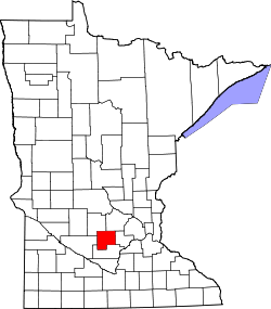
Lynn Township, McLeod County, Minnesota

Last updated

Lynn Township, Minnesota
USA Minnesota location map.svg
Red pog.svg
Lynn Township
Usa edcp location map.svg
Red pog.svg
Lynn Township
Coordinates: 44°52′2″N94°25′46″W / 44.86722°N 94.42944°W / 44.86722; -94.42944
Country United States
State Minnesota
County McLeod
Area
[1]
  Total33.03 sq mi (85.5 km2)
  Land31.77 sq mi (82.3 km2)
  Water1.26 sq mi (3.3 km2)
Elevation
1,070 ft (326 m)
Population
 (2020) [2]
  Total519
  Density16.3/sq mi (6.3/km2)
Time zone UTC-6 (Central (CST))
  Summer (DST) UTC-5 (CDT)
ZIP Codes
55350 (Hutchinson)
55385 (Stewart)
FIPS code 27-085-38798 [3]
GNIS feature ID0664848 [4]

Lynn Township is a township in McLeod County, Minnesota, United States. The population was 519 at the 2020 census. [2]

Contents

History

According to Warren Upham, Lynn Township may be named after Lynn, Massachusetts. [5]

Geography

The township is in western McLeod County. It is bordered to the west by Renville County and to the northeast by Hutchinson, the largest city in McLeod County.

According to the U.S. Census Bureau, the Lynn Township has a total area of 33.0 square miles (85 km2), of which 31.8 square miles (82 km2) are land and 1.3 square miles (3.4 km2), or 3.82%, are water. [1]

Demographics

Historical population
CensusPop.Note
1870 243
1880 598146.1%
1890 72821.7%
1900 82313.0%
1910 753−8.5%
1920 7550.3%
1930 7935.0%
1940 8284.4%
1950 794−4.1%
1960 708−10.8%
1970 7789.9%
1980 693−10.9%
1990 7345.9%
2000 604−17.7%
2010 550−8.9%
2020 519−5.6%
U.S. Decennial Census [6]

As of the census [3] of 2000, there were 604 people, 216 households, and 174 families residing in the township. The population density was 19.0 inhabitants per square mile (7.3/km2). There were 226 housing units at an average density of 7.1 per square mile (2.7/km2). The racial makeup of the township was 99.01% White, 0.17% Asian, 0.33% from other races, and 0.50% from two or more races. Hispanic or Latino of any race were 0.50% of the population.

There were 216 households, out of which 35.2% had children under the age of 18 living with them, 70.8% were married couples living together, 3.2% had a female householder with no husband present, and 19.4% were non-families. 18.5% of all households were made up of individuals, and 10.2% had someone living alone who was 65 years of age or older. The average household size was 2.80 and the average family size was 3.19.

In the township the population was spread out, with 30.0% under the age of 18, 5.1% from 18 to 24, 25.8% from 25 to 44, 25.8% from 45 to 64, and 13.2% who were 65 years of age or older. The median age was 39 years. For every 100 females, there were 111.9 males. For every 100 females age 18 and over, there were 108.4 males.

The median income for a household in the township was $51,250, and the median income for a family was $55,972. Males had a median income of $30,521 versus $26,146 for females. The per capita income for the township was $19,699. About 4.0% of families and 5.9% of the population were below the poverty line, including 8.4% of those under age 18 and 14.5% of those age 65 or over.

Related Research Articles

<span class="mw-page-title-main">McLeod County, Minnesota</span> County in Minnesota, United States

McLeod County is a county in the U.S. state of Minnesota. At the 2020 census, the population was 36,771. Its county seat is Glencoe.

Williams Township is a township in Aitkin County, Minnesota, United States. The population was 144 as of the 2010 census.

McPherson Township is a township in Blue Earth County, Minnesota, United States. The population was 470 as of the 2000 census.

McKinley Township is a township in Cass County, Minnesota, United States. The population was 130 at the 2000 census. McKinley Township was named for William McKinley, 25th President of the United States.

Acoma Township is a township in McLeod County, Minnesota, United States. The population was 1,130 at the 2020 census.

Bergen Township is a township in McLeod County, Minnesota, United States. The population was 910 at the 2020 census.

Collins Township is a township in McLeod County, Minnesota, United States. The population was 436 at the 2020 census.

Glencoe Township is a township in McLeod County, Minnesota, United States. The population was 514 at the 2020 census.

Hale Township is a township in McLeod County, Minnesota, United States. The population was 917 at the 2020 census.

<span class="mw-page-title-main">Hassan Valley Township, McLeod County, Minnesota</span> Township in Minnesota, United States

Hassan Valley Township is a township in McLeod County, Minnesota, United States. The population was 643 at the 2020 census.

Helen Township is a township in McLeod County, Minnesota, United States. The population was 833 at the 2020 census.

Hutchinson Township is a township in McLeod County, Minnesota, United States. The population was 1,215 at the 2020 census.

Penn Township is a township in McLeod County, Minnesota, United States. The population was 322 at the 2020 census.

Rich Valley Township is a township in McLeod County, Minnesota, United States. The population was 669 at the 2020 census.

Round Grove Township is a township in McLeod County, Minnesota, United States. The population was 236 at the 2020 census.

Sumter Township is a township in McLeod County, Minnesota, United States. The population was 486 at the 2020 census.

Winsted Township is a township in McLeod County, Minnesota, United States. The population was 936 at the 2020 census.

Green Isle Township is a township in Sibley County, Minnesota, United States. The population was 556 at the 2000 census.

Cotton Township is a township in Saint Louis County, Minnesota, United States. The population was 445 at the 2010 census.

<span class="mw-page-title-main">Silver Lake, Minnesota</span> City in Minnesota, United States

Silver Lake is a city in McLeod County, Minnesota, United States. The population was 866 at the 2020 census.

References

  1. 1 2 "2023 U.S. Gazetteer Files: Minnesota". United States Census Bureau. Retrieved January 18, 2024.
  2. 1 2 "P1. Race – Lynn township, McLeod County, Minnesota: 2020 DEC Redistricting Data (PL 94-171)". U.S. Census Bureau. Retrieved January 18, 2024.
  3. 1 2 "U.S. Census website". United States Census Bureau . Retrieved January 31, 2008.
  4. "US Board on Geographic Names". United States Geological Survey. October 25, 2007. Retrieved January 31, 2008.
  5. Upham, Warren (1920). Minnesota Geographic Names: Their Origin and Historic Significance. Minnesota Historical Society. p.  318.
  6. "Decennial Census Official Publications". Census.gov. Retrieved January 18, 2024.