
The National Register of Historic Places in the United States is a register including buildings, sites, structures, districts, and objects. The Register automatically includes all National Historic Landmarks as well as all historic areas administered by the U.S. National Park Service. Since its introduction in 1966, more than 90,000 separate listings have been added to the register.

Pictograph Cave is an area of three caves located 5 miles (8.0 km) south of Billings, Montana, United States, preserved and protected in the 23-acre (9.3 ha) Pictograph Cave State Park.

This is a list of properties and historic districts in Montana that are listed on the National Register of Historic Places. The state's more than 1,100 listings are distributed across all of its 56 counties.

Traveler's Rest was a stopping point of the Lewis and Clark Expedition, located about one mile south of Lolo, Montana. The expedition stopped from September 9 to September 11, 1805, before crossing the Bitterroot Mountains, and again on the return trip from June 30 to July 3, 1806. Traveler's Rest is at the eastern end of the Lolo Trail. It was declared a National Historic Landmark in 1960 and added to the National Register of Historic Places in 1966. The boundaries were subsequently revised, and mostly lie within the 51-acre (21 ha) Traveler's Rest State Park, which is operated by the Montana Fish, Wildlife & Parks. Significant archeological findings made in 2002, including latrine sites with traces of mercury and fire hearths, make this the only site on the Lewis and Clark National Historic Trail that has yielded physical proof of the explorers' presence. Records made by Lewis and Clark often spell "Traveler's" as "Traveller's". This spot is largely unchanged from the days of Lewis and Clark. From this location, Lewis and Clark split up to explore Montana during their return trip, not reuniting until they reached Sanish, North Dakota.
This is a list of the National Register of Historic Places listings in Cascade County, Montana. It is intended to be a complete list of the properties and districts on the National Register of Historic Places in Cascade County, Montana, United States. The locations of National Register properties and districts for which the latitude and longitude coordinates are included below, may be seen in a map.
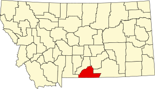
This is a list of the National Register of Historic Places listings in Carbon County, Montana.

This is a list of the National Register of Historic Places listings in Deer Lodge County, Montana. It is intended to be a complete list of the properties and districts on the National Register of Historic Places in Deer Lodge County, Montana, United States. All sites are located in the city of Anaconda, which is consolidated with Deer Lodge County. The locations of National Register properties and districts for which the latitude and longitude coordinates are included below, may be seen in a map.

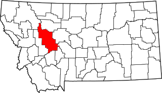
This is a list of the National Register of Historic Places listings in Flathead County, Montana.

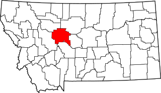
This is a list of the National Register of Historic Places listings in Gallatin County, Montana.
This is a list of the National Register of Historic Places listings in Lewis and Clark County, Montana.
This is a list of the National Register of Historic Places listings in Missoula County, Montana. It is intended to be a complete list of the properties and districts on the National Register of Historic Places in Missoula County, Montana, United States. The locations of National Register properties and districts for which the latitude and longitude coordinates are included below, may be seen in a map.

This is a list of the National Register of Historic Places listings in Ravalli County, Montana.

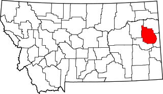
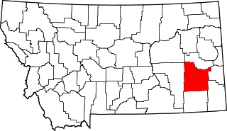
This is a list of the National Register of Historic Places listings in Yellowstone County, Montana. It is intended to be a complete list of the properties and districts on the National Register of Historic Places in Yellowstone County, Montana, United States. The locations of National Register properties and districts for which the latitude and longitude coordinates are included below, may be seen in a map.

This is a list of the National Register of Historic Places listings in Sanders County, Montana. It is intended to be a complete list of the properties and districts on the National Register of Historic Places in Sanders County, Montana, United States. The locations of National Register properties and districts for which the latitude and longitude coordinates are included below, may be seen in a map.

This is a list of the National Register of Historic Places listings in Park County, Montana.

This is a list of the National Register of Historic Places listings in Glacier County, Montana. It is intended to be a complete list of the properties and districts on the National Register of Historic Places in Glacier County, Montana, United States. The locations of National Register properties and districts for which the latitude and longitude coordinates are included below, may be seen in a map.

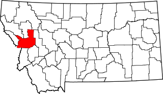
This is a list of the National Register of Historic Places listings in Beaverhead County, Montana. It is intended to be a complete list of the properties and districts on the National Register of Historic Places in Beaverhead County, Montana, United States. The locations of National Register properties and districts for which the latitude and longitude coordinates are included below, may be seen in a map.
This is a list of the National Register of Historic Places listings in Dawson County, Montana. It is intended to be a complete list of the properties and districts on the National Register of Historic Places in Dawson County, Montana, United States. The locations of National Register properties and districts for which the latitude and longitude coordinates are included below, may be seen in a map.
This is a list of the National Register of Historic Places listings in Custer County, Montana. It is intended to be a complete list of the properties and districts on the National Register of Historic Places in Custer County, Montana, United States. The locations of National Register properties and districts for which the latitude and longitude coordinates are included below, may be seen in a map.

This is a list of the National Register of Historic Places listings in Mineral County, Montana.