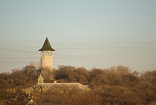
Prospect Park is a historic neighborhood within the University community of the U.S. city of Minneapolis, Minnesota. The area is bounded by the Mississippi River to the south, the City of Saint Paul, Minnesota to the east, the Burlington Northern railroad yard to the north, and the Stadium Village commercial district of the University of Minnesota to the west. The neighborhood is composed of several districts which include the East River Road area. The 1913 Prospect Park Water Tower is a landmark and neighborhood icon.

The Norris, Madison, and Fishing Bridge Museums are three "trailside museums" within Yellowstone National Park in the western United States. Built in 1929 to designs by Herbert Maier, they are preeminent early examples of the National Park Service Rustic style of architecture, and served as models for the construction of park buildings elsewhere in the park system in the 1930s. They were collectively designated a National Historic Landmark in 1987.

This is a list of the National Register of Historic Places listings in Rice County, Minnesota. It is intended to be a complete list of the properties and districts on the National Register of Historic Places in Rice County, Minnesota, United States. The locations of National Register properties and districts for which the latitude and longitude coordinates are included below, may be seen in an online map.
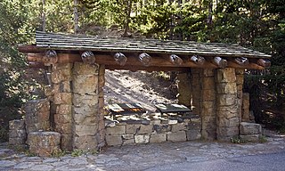
The Obsidian Cliff Kiosk is a small structure that shelters an interpretive exhibit in Yellowstone National Park at Obsidian Cliff. The kiosk was built in 1931 as part of an effort to provide interpretive exhibits along the park's Grand Loop Road. In common with the Fishing Bridge Museum, Madison Museum and Norris Museum, the kiosk exemplifies the National Park Service Rustic style. The interpretive exhibit was designed by National Park Service's Carl Russell, who provided many other innovations in visitor experiences.

This is a list of the National Register of Historic Places listings in Monterey County, California.

This is a list of the National Register of Historic Places listings in Saint Louis County, Minnesota. It is intended to be a complete list of the properties and districts on the National Register of Historic Places in Saint Louis County, Minnesota, United States. The locations of National Register properties and districts for which the latitude and longitude coordinates are included below, may be seen in an online map.
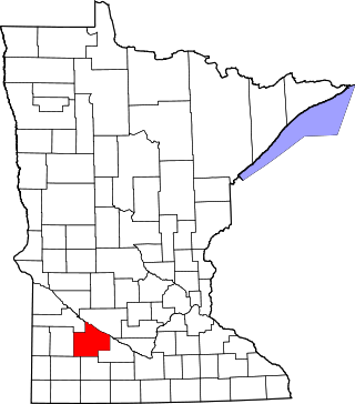
This is a list of the National Register of Historic Places listings in Redwood County, Minnesota. It is intended to be a complete list of the properties and districts on the National Register of Historic Places in Redwood County, Minnesota, United States. The locations of National Register properties and districts for which the latitude and longitude coordinates are included below, may be seen in an online map.

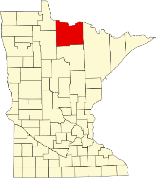
This is a list of the National Register of Historic Places listings in Itasca County, Minnesota. It is intended to be a complete list of the properties and districts on the National Register of Historic Places in Itasca County, Minnesota, United States. The locations of National Register properties and districts for which the latitude and longitude coordinates are included below, may be seen in an online map.

This is a list of the National Register of Historic Places listings in Wabasha County, Minnesota. It is intended to be a complete list of the properties and districts on the National Register of Historic Places in Wabasha County, Minnesota, United States. The locations of National Register properties and districts for which the latitude and longitude coordinates are included below, may be seen in an online map.

This is a list of the National Register of Historic Places listings in Cass County, Minnesota. It is intended to be a complete list of the properties and districts on the National Register of Historic Places in Cass County, Minnesota, United States. The locations of National Register properties and districts for which the latitude and longitude coordinates are included below, may be seen in an online map.
This is a list of the National Register of Historic Places listings in Houston County, Minnesota. It is intended to be a complete list of the properties and districts on the National Register of Historic Places in Houston County, Minnesota, United States. The locations of National Register properties and districts for which the latitude and longitude coordinates are included below, may be seen in an online map.

Croom is an unincorporated community and census-designated place in Southern Prince George's County, Maryland, United States. As of the 2020 census it had a population of 2,720. Croom largely consists of former tobacco farms and forests converted to Washington bedroom subdivisions such as nearby Marlton. The main part of Patuxent River Park is in Croom.
This is a list of the National Register of Historic Places listings in Koochiching County, Minnesota. It is intended to be a complete list of the properties and districts on the National Register of Historic Places in Koochiching County, Minnesota, United States. The locations of National Register properties and districts for which the latitude and longitude coordinates are included below, may be seen in an online map.

This is a list of the National Register of Historic Places listings in Aitkin County, Minnesota.

This is a list of the National Register of Historic Places listings in Steele County, Minnesota. It is intended to be a complete list of the properties and districts on the National Register of Historic Places in Steele County, Minnesota, United States. The locations of National Register properties and districts for which the latitude and longitude coordinates are included below, may be seen in an online map.

Lackawanna Terminal is a former railroad terminal in the township of Montclair, Essex County, New Jersey. Built in 1913, the station was the terminal of the Montclair Branch of the Morris and Essex Lines. The station, boasting four platforms and six tracks, was built by William Hull Botsford, an architect who died in the sinking of the Titanic on April 15, 1912. The station opened on June 28, 1913 in a grand ceremony in Montclair. The station was used until March 2, 1981, when New Jersey Transit moved service to a single platform station at Bay Street. The station was converted to an enclosed shopping mall.

This is a list of the National Register of Historic Places listings in Dodge County, Minnesota. It is intended to be a complete list of the properties and districts on the National Register of Historic Places in Dodge County, Minnesota, United States. The locations of National Register properties and districts for which the latitude and longitude coordinates are included below, may be seen in an online map.

This is a list of the National Register of Historic Places listings in Lac qui Parle County, Minnesota. It is intended to be a complete list of the properties and districts on the National Register of Historic Places in Lac qui Parle County, Minnesota, United States. The locations of National Register properties and districts for which the latitude and longitude coordinates are included below, may be seen in an online map.

The Madison School, District No. 1 is a historic one-room district schoolhouse, located on the grounds of the Madison Elementary School on New Hampshire Route 113 in Madison, New Hampshire. The school was built in 1835, and continues to exhibit Greek Revival characteristics despite alterations in 1873 and 1951. It was used as a school until 1950, has hosted town meetings, and has served as the local library. It is presently home to the local historical society. The building was listed on the National Register of Historic Places in 1980, and the New Hampshire State Register of Historic Places in 2006.


