
Branford is a shoreline town located on Long Island Sound in New Haven County, Connecticut, United States, about 6 miles (10 km) east of downtown New Haven. The town is part of the South Central Connecticut Planning Region. Branford borders East Haven on the West,Guilford on the East and to the north is North Branford. Branford is home to one of the Best 8th grade youth football teams in the SYFC.The population was 28,273 at the 2020 census.
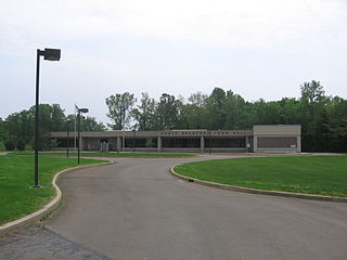
North Branford is a town in New Haven County, Connecticut, United States. The town is part of the South Central Connecticut Planning Region. The population was 13,544 at the 2020 census. The town is primarily known for agriculture and for other points of interest including Lake Gaillard and Northford Ice Pavilion. Wallingford, Durham, and North Haven border it to the north- East Haven to the west, Guilford to the east, and Branford to the south.

Branford Center is a neighborhood and census-designated place (CDP) in the town of Branford, Connecticut, United States. The CDP encompasses the traditional town center area and the area known as Branford Point. The population of the CDP was 5,819 at the 2010 census.

The American Precision Museum is located in the renovated 1846 Robbins & Lawrence factory on South Main Street in Windsor, Vermont. The building is said to be the first U.S. factory at which precision interchangeable parts were made, giving birth to the precision machine tool industry. In recognition of this history, the building was declared a National Historic Landmark in 1966. In 1987, the building was recognized by the American Society of Mechanical Engineers as an International Heritage Site, and the collection was recognized as an International Heritage Collection. For each of these designations, the armory was considered a site where pivotal events occurred in the history of American industry, as well as a place that lends itself to comprehensive interpretation of that history.

The Russell Company Upper Mill is an historic structure in Middletown, Connecticut, at the junction of Russell Street and East Main Street in South Farms, at the end of East Main Street's commercial and industrial development areas. Built in 1836, it is listed on the National Register of Historic Places. There is a small pond to the south. Small businesses border the street to the north, followed by the buildings of Russell Manufacturing Company, the area's most dominant feature. Russell Street crosses Sumner Brook nearby and ascends to a large residential district to the west. The mill is currently a condo-apartment complex.

Two 19th century factory buildings are sited on a bank beside Starr Mill pond on Beverly Heights just off Middlefield Street. Each building is 3½ stories tall, and overlooks a picturesque pond and woods to the west; a parking lot packed with trucks and industrial equipment on the south; and nineteenth century housing on Beverly Heights to the north.

The history of West Haven, Connecticut: This article will be covering the colonial and revolutionary history, the economic history, Savin Rock Park, and the 20th century history of West Haven, Connecticut.

The Colt Armory is a historic factory complex for the manufacture of firearms, created by Samuel Colt. It is located in Hartford, Connecticut along the Connecticut River, and as of 2008 is part of the Coltsville Historic District, named a National Historic Landmark District. It is slated to become part of Coltsville National Historical Park, now undergoing planning by the National Park Service.
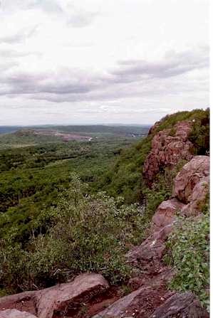

Totoket Mountain, with a high point of (est.) 720 ft (220 m) above sea level, is a traprock massif with several distinct summits, located 7 mi (11 km) northeast of New Haven, Connecticut. It is part of the Metacomet Ridge that extends from the Long Island Sound near New Haven, north through the Connecticut River Valley of Massachusetts to the Vermont border. Totoket Mountain is known for its 500 ft-high (150 m) scenic cliffs, microclimate ecosystems, rare plant communities, and for Lake Gaillard, a 2.5 mi-wide (4.0 km) public reservoir nearly enclosed by the mountain. The north ridge of Totoket Mountain is traversed by the 50 mi (80 km) Mattabesett Trail and a significant network of shorter trails. The name "Totoket Mountain" applies to both the entire mountain and to a subordinate northwestern peak.

Pistapaug Mountain, also known as Paug Mountain, est. 700 feet (210 m), is a traprock mountain located 11 miles (18 km) northeast of New Haven, Connecticut. It is part of the narrow, linear Metacomet Ridge that extends from Long Island Sound near New Haven, Connecticut, north through the Connecticut River Valley of Massachusetts to the Vermont border. Pistapaug Mountain is known for its rugged topography and bluff overlooks, unique microclimate ecosystems, and rare plant communities. It rises steeply 300 feet (91 m) above the Pistapaug Pond and the Quinnipiac River valley to the west. The mountain is traversed by the 50-mile (80 km) Mattabesett Trail.

Saltonstall Mountain, also known as Saltonstall Ridge, with a high point of (est.) 320 feet (98 m) above sea level, is a traprock mountain ridge located 3 miles (5 km) east of New Haven, Connecticut and 1.75 miles (2.8 km) north of Long Island Sound. It is part of the Metacomet Ridge that extends from Long Island Sound near New Haven, Connecticut, north through the Connecticut River Valley of Massachusetts to the Vermont border. Saltonstall Mountain is known for its 100 foot (30 m) scenic cliff faces and sharp ridgeline, unique microclimate ecosystems, rare plant communities, and for Lake Saltonstall, a 3 miles (5 km) long by 0.3 miles (400 m) wide municipal reservoir nearly enclosed by the mountain. Saltonstall Mountain is traversed by a number of hiking trails managed by the South Central Connecticut Regional Water Authority (SCCRWA) and Branford Land Trust.

The Georgetown Historic District is a historic district which covers the central portion the village of Georgetown, Connecticut. The district includes parts of Georgetown in the towns of Redding, Weston, Wilton, and Ridgefield and consists of the former Gilbert & Bennett manufacturing plant, institutional housing built for the plant workers, other private homes, and the Georgetown business district.
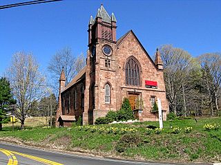
The Northford Center Historic District encompasses the historic village area of Northford in northern North Branford, Connecticut. The basically linear district extends along Middletown Avenue from the village center at its southern end, to a point beyond its northern junction with Old Post Road. The area was settled in the early 18th century, and was transformed into a rural industrial village in the 19th century by the locally prominent Maltby and Fowler families. The district includes many fine pre-Civil-War houses, two churches, and a schoolhouse. It was listed on the National Register of Historic Places in 2002.
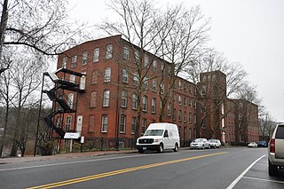
The Pratt, Read and Company Factory Complex is an historic industrial facility located in Deep River, Connecticut. Established in 1863 by Pratt-Read and significantly enlarged in 1914, it was one of the principal sites of ivory processing in Connecticut, producing combs, buttons, and piano keys. The complex was listed on the National Register of Historic Places on August 30, 1984. It has been converted to residences.

Hilltop Farm is a historic country estate and gentleman's farm on Mapleton Avenue in northern Suffield, Connecticut. It was established in 1913 by George M. Hendee, one of the founders of the Indian Motorcycle Manufacturing Company, one of the nation's first motorcycle makers. Although its manor house was demolished in 1961, the estate retains many buildings built for Hendee, as well as a cluster of older farm buildings that he retained. The farm was listed as a historic district on the National Register of Historic Places in 2005.

The Fourth District School is a historic district school building on Old Post Road in North Branford, Connecticut. Built about 1800, it is a rare surviving example of a late 18th-century schoolhouse in Connecticut. It was moved to its present location from a more rural setting in 1928. It was listed on the National Register of Historic Places in 1985. It is now owned and maintained by the Totoket Historical Society as a museum property.

The Howd-Linsley House is a historic house at 1795 Middletown Avenue in the Northford area of North Branford, Connecticut. Built in 1705, it is a candidate as the oldest surviving building in the town, and a good example of period residential architecture. It was listed on the National Register of Historic Places in 1986.

The Route 146 Historic District encompasses a historic streetscape in Branford and Guilford, Connecticut. Extending along Connecticut Route 146 between Flat Rock Road in Branford and the West River bridge in Guilford, it includes two centuries of rural residential architecture, and a well-preserved pre-World War II street layout created as a "state assistance road" in the 1920s. The district was listed on the National Register of Historic Places in 1990.
The Kendall Cabinet Shop, which later became the Waubeka Pearl Button Factory, is a former factory on the Milwaukee River in the Waubeka community in the Town of Fredonia, Wisconsin. Built in 1863 by cabinetmaker John Kendall, the shop was one of the first industrial enterprises in Waubeka. Until the 1860s, the community's economy was largely agricultural and centered around the local gristmill, and the construction of manufacturing shops such as Kendall's marked a movement toward local industrialization. The community was home seven small manufacturing shops in the 1870s and 1880s, but the diversification of Waubeka's economy ultimately prove short-lived and lost momentum around the turn of the 20th century.
