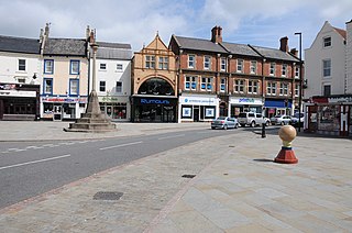
Manthorpe, Grantham

Last updated

Manthorpe
St.John's church, Manthorpe, Lincs. - geograph.org.uk - 119668.jpg
Parish church of St John the Evangelist
Lincolnshire UK location map.svg
Red pog.svg
Manthorpe
Location within Lincolnshire
OS grid reference SK920377
  London 100 mi (160 km)  south
Civil parish
District
Shire county
Region
Country England
Sovereign state United Kingdom
Post town Grantham
Postcode district NG31
Dialling code 01476
Police Lincolnshire
Fire Lincolnshire
Ambulance East Midlands
UK Parliament
List of places
UK
England
Lincolnshire
52°55′44″N0°37′57″W / 52.928920°N 0.632405°W / 52.928920; -0.632405 Coordinates: 52°55′44″N0°37′57″W / 52.928920°N 0.632405°W / 52.928920; -0.632405

Manthorpe is a village in the South Kesteven district of Lincolnshire, England. It is on the northern edge of the town of Grantham and on the Grantham to Lincoln A607 road, between the East Coast Main Line and the River Witham. The village is part of the civil parish of Belton and Manthorpe. [1]

Contents

History

Before the 19th century, Manthorpe parish was agricultural and known as Little Gonerby-cum-Manthorpe. The Grantham to Lincoln road followed what is now Low Road, across the river behind Swallow's Mill, through Belton Park and along the old route to the Roman town of Ancaster on the Ermine Street Roman Road.

In 1810 the Brownlow family, owners of Belton Park and House just north of Manthorpe, built a new road from Grantham to Belton. In the 1840s and 1850s new houses, a church and school were built, and established properties were renovated. [1] [2] [3]

The Church of England parish church of St John the Evangelist was designed by architect George Gordon Place of Nottingham and built in 1847–48. It was built as an estate church by the Brownlow family to serve Belton Estate workers. [2] [3] [4]

The 1885 Kelly's Directory describes Manthorpe as "a small and pleasant village". It was an ecclesiastical district established in 1849 from the civil parish of Grantham and the village formed a township with Little Gonerby. It was within the Grantham parliamentary borough, the rural deanery of North Grantham, and the archdeaconry and Diocese of Lincoln. Manthorpe's church of St John the Evangelist, consecrated by the Bishop of Lincoln in 1848, is in early Decorated style. It consists of a chancel, nave, south porch, and vestry, and a tower with two bells and a spire 50 feet (15 m) high. The church, graveyard and parsonage sites were provided by Earl Brownlow, who also paid for construction of the parsonage. The earl's brother, Richard Cust, St John's Rector in 1885, built the church at his own expense. Bequests from the brothers provided the living – a vicarage united with that of Londonthorpe. The parish register dates from 1849, but earlier records for Manthorpe appear in Grantham registers. [5]

Kelly's describes the area as being skirted on the north by a formation of blue lias, and on the south by oolite, with land being of sand with a gravel subsoil. Chief crops grown were wheat, barley, oats and turnips, in a township area of 1,228 acres (497 ha) that included Little Gonerby. In 1881 the ecclesiastical district contained a population of 243, and the Manthorpe-cum-Little Gonerby township, 3,567. An infants school for 50 children, with an average attendance of 30, was erected in 1865 with financial support from Earl Brownlow. Township occupations included four farmers, two cow-keepers, a grazier, a wheelwright, three shopkeepers, and a miller at Manthorpe Mill, a watermill. [5]

In the early 20th century, houses began to be connected to electricity, with others supplied with water by a village pump or their own well. Eventually the Brownlow estate connected water and electricity to all households.[ citation needed ]

By the late 1940s there were about a dozen houses west of Manthorpe Road, with the village still separated from Grantham.[ citation needed ] During the 1950s and 1960s houses were built west of Manthorpe Road and on the side of the River Witham. In the 1960s Grantham became conjoined to the village after the Manthorpe housing estate was built on the north side of the town. When the 6th Lord Brownlow died, in 1978, further land became available and most cottages in Manthorpe village were sold.[ citation needed ]

Community

The nearest schools are situated on the Manthorpe estate in Grantham. These are The Priory Ruskin Academy, (formerly the Central Technology & Sports College), a mixed-sex secondary school on Rushcliffe Road, and Cliffedale Primary School on Northcliffe Road.

The ecclesiastical parish is the benefice of Grantham Manthorpe, of the Deanery of Grantham. The Vicar of Manthorpe since 2014 is Fr Stuart Cradduck, who is also the Rector of St Wulfram's, Grantham. [6] [2] [7]

The nearest shop is a convenience store on the corner of Sandcliffe Road and Rushcliffe Road, on the Manthorpe estate. The closest supermarkets are in Grantham. Manthorpe has its own Residents' Association. [8]

Related Research Articles

<span class="mw-page-title-main">Grantham</span> Market town and rail junction, Lincolnshire, England

Grantham is a market and industrial town in the South Kesteven district of Lincolnshire, England, situated on the banks of the River Witham and bounded to the west by the A1 road. It lies some 23 miles (37 km) south of the Lincoln and 22 miles (35 km) east of Nottingham. The population in 2016 was put at 44,580. The town is the largest settlement and the administrative centre of South Kesteven District.

<span class="mw-page-title-main">South Kesteven</span> Local government district in Lincolnshire, England

South Kesteven is a local government district in Lincolnshire, England, forming part of the traditional Kesteven division of the county. It covers Bourne, Grantham, Market Deeping and Stamford. The 2011 census reports 133,788 people at 1.4 per hectare in 57,344 households. The district borders the counties of Cambridgeshire, Leicestershire, Northamptonshire, Nottinghamshire and Rutland. It is also bounded by the Lincolnshire districts of North Kesteven and South Holland.

<span class="mw-page-title-main">Baron Brownlow</span> Title in the Peerage of Great Britain

Baron Brownlow, of Belton in the County of Lincoln, is a title in the Peerage of Great Britain. It was created in 1776 for Sir Brownlow Cust, 4th Baronet. The Cust family descends from Richard Cust (1622-1700) of The Black Friars, Stamford, who represented Lincolnshire and Stamford in Parliament. In 1677 he was created a baronet, "of Stamford in the County of Lincoln". He was succeeded by his grandson Richard Cust, 2nd Baronet, who married Anne Brownlow, daughter of Sir William Brownlow, 4th Baronet, "of Humby", Lincolnshire, and sister and sole heiress of John Brownlow, 1st Viscount Tyrconnel, 5th Baronet of Belton House, Lincolnshire. The 2nd Baronet's son Sir John Cust, 3rd Baronet, sat as a Member of Parliament for Grantham and served as Speaker of the House of Commons from 1761 to 1770 and in 1754 inherited the Brownlow estates, including Belton, on the death of his childless maternal uncle Viscount Tyrconnel. His son Brownlow Cust, 4th Baronet represented Ilchester, Somerset, and Grantham in Parliament and in 1776 was raised to the peerage as Baron Brownlow, "of Belton in the County of Lincoln", chiefly in recognition of his father's services. He was succeeded by his son John Cust, 2nd Baron Brownlow who had sat as a Member of Parliament for Clitheroe, Lancashire, and also served as Lord Lieutenant of Lincolnshire for many years. In 1815 he was created Viscount Alford, "in the County of Lincoln" and Earl Brownlow both in the Peerage of the United Kingdom. In 1810 the future 1st Earl had married Sophia Hume, a daughter of Sir Abraham Hume, 2nd Baronet, of Wormleybury, by his wife Lady Amelia Egerton, a great-granddaughter of John Egerton, 3rd Earl of Bridgewater.

<span class="mw-page-title-main">Belton, South Kesteven</span> Human settlement in England

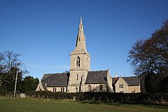
Belton is a village in the civil parish of Belton and Manthorpe, in the South Kesteven district of Lincolnshire, England. It is situated on the A607 road, and 3 miles (5 km) north from the market town of Grantham.

<span class="mw-page-title-main">Barkston</span> English village in the South Kesteven district of Lincolnshire

Barkston is an English village and civil parish in the South Kesteven district of Lincolnshire. The parish population was 497 at the 2001 census and 493 at the 2011 census. The village lies about 4 miles (6 km) north of the market town of Grantham, on the A607, just south of the junction with the A153 to Ancaster.

Barrowby is a village and civil parish in the South Kesteven district of Lincolnshire, England. It is 2 miles (3.2 km) west of Grantham. It overlooks the Vale of Belvoir and has a Grade I listed parish church. The hamlet of Casthorpe is part of the parish. The 2001 Census listed 795 households and a population of 1,996, which fell to 840 households with 1,952 inhabitants at the 2011 census. It was estimated at 1,986 in 2019.

<span class="mw-page-title-main">Belton and Manthorpe</span>

Belton and Manthorpe is a civil parish in the South Kesteven district of Lincolnshire, England, consisting of Belton and Manthorpe, just north of Grantham. According to the 2001 census it had a population of 517 in 192 households. By 2011 the authorities recorded 528 people in 216 homes.

<span class="mw-page-title-main">South Witham</span> Village and civil parish in the South Kesteven district of Lincolnshire, England

South Witham is a village and civil parish in the South Kesteven district of Lincolnshire, England. The population of the civil parish at the 2011 census was 1,533. It is situated 10 miles (16 km) south of Grantham, 10 miles east of Melton Mowbray and 10 miles (16 km) north of Oakham. The village is close to the Leicestershire and Rutland borders.

<span class="mw-page-title-main">Castle Bytham</span> Village and civil parish of around 300 houses in South Kesteven, Lincolnshire, England

Castle Bytham is a village and civil parish of around 300 houses in South Kesteven, Lincolnshire, England. It is located 9 miles (15 km) north of Stamford and 9 miles (15 km) west of Bourne.The population was measured at 768 in 317 households at the 2011 census.

<span class="mw-page-title-main">Great Hale</span> Village and civil parish in the North Kesteven district of Lincolnshire, England

Great Hale is a village and civil parish in the North Kesteven district of Lincolnshire, England. The population of the civil parish at the 2011 census was 778. It is situated on the B1394 road, immediately south from Heckington and 1.7 miles (2.7 km) north from Helpringham.

<span class="mw-page-title-main">Colsterworth</span> Village in the South Kesteven district of Lincolnshire, England

Colsterworth is a village and civil parish in the South Kesteven district of Lincolnshire, England, less than half a mile west of the A1, about 7 miles (11 km) south of Grantham, and 12 miles (19 km) north-west of Stamford. The village with the hamlet of Woolsthorpe-by-Colsterworth had a recorded population of 1,713 at the time of the 2011 Census, in an area of 1,465 hectares.

<span class="mw-page-title-main">Edenham</span> Village and civil parish in the South Kesteven district of Lincolnshire, England

Edenham is a village and civil parish in the South Kesteven district of Lincolnshire, England. It is approximately 3 miles (5 km) north-west of Bourne, and on the A151 road. While the civil parish is called 'Edenham', the parish council is called Edenham, Grimsthorpe, Elsthorpe & Scottlethorpe Parish Council. The population of the civil parish at the 2011 census was 291.

<span class="mw-page-title-main">Wyville</span> Village and civil parish in the South Kesteven district of Lincolnshire, England

Wyville is a village in the civil parish of Wyville cum Hungerton, in the South Kesteven district of Lincolnshire, England, and situated approximately 5 miles (8 km) south-west from Grantham The whole parish covers about 1,670 acres (6.8 km2). The population is included in the civil parish of Little Ponton and Stroxton.

<span class="mw-page-title-main">A607 road</span>

The A607 is an A road in England that starts in Belgrave, Leicester and heads northeastwards through Leicestershire and the town of Grantham, Lincolnshire, terminating at Bracebridge Heath, a village on the outskirts of Lincoln. It is a primary route from Thurmaston to the A1 junction at Grantham.

Great Humby is a hamlet in the South Kesteven district of Lincolnshire, England. It lies in the civil parish of Ropsley and Humby, 6 miles (9.7 km) east from Grantham, 1.5 miles (2.4 km) south-east from Ropsley and 3 miles (4.8 km) south from the A52. Little Humby, a larger hamlet, is 720 yards (658.4 m) to the north. It is in the civil parish of Ropsley and Humby.

<span class="mw-page-title-main">Witham on the Hill</span> Village and civil parish in the South Kesteven district of Lincolnshire, England

Witham on the Hill is a village and civil parish in the South Kesteven district of Lincolnshire, England. The population of the civil parish was 260 at the 2011 census.

<span class="mw-page-title-main">Great Gonerby</span> Village and civil parish in the South Kesteven district of Lincolnshire, England

Great Gonerby is a village and civil parish in the South Kesteven district of Lincolnshire, England. The population of the civil parish at the 2011 census was 2,200. It is situated less than 1 mile (1.6 km) north from Grantham. To its north is Gonerby Moor, part of Great Gonerby civil parish, and the A1 road. It is 330 feet (101 m) above sea level and overlooks the Vale of Belvoir to the west and Grantham to the south.

Central Technology & Sports College was a secondary school in the north of Grantham in Lincolnshire, England. It became part of The Priory Ruskin Academy in 2010.

<span class="mw-page-title-main">Londonthorpe and Harrowby Without</span>

Londonthorpe and Harrowby Without is a civil parish in the South Kesteven district of Lincolnshire, England. According to the 2001 Census it had a population of 4,344, in 1743 households, increasing to a population of 5,133 at the 2011 census. It includes the village of Londonthorpe and the hamlet of Harrowby, Lincolnshire.

References

  1. 1 2 "Belton & Manthorpe Parish Council website". Lincolnshire County Council. Retrieved 15 March 2013.
  2. 1 2 3 "St John the Evangelist, Manthorpe". Archived from the original on 24 December 2008. Retrieved 25 January 2010.
  3. 1 2 Pevsner, N; Harris, J; Antram, N (1989). Lincolnshire. The Buildings of England. London. p. 550. ISBN   978-0140710274.
  4. Historic England. "Church of Saint John (Grade II) (1194836)". National Heritage List for England . Retrieved 16 March 2013.
  5. 1 2 Kelly's Directory of Lincolnshire with the port of Hull 1885, p. 571.
  6. http://www.stjohnmanthorpe.org.uk/contact.php. [ dead link ]
  7. "Grantham Manthorpe P C C". Diocese of Lincoln. Archived from the original on 16 January 2014. Retrieved 16 March 2013.
  8. https://www.hotfrog.co.uk/company/1096950376136704