
Gadchiroli district is an administrative district in Maharashtra, India. The city of Gadchiroli is the administrative headquarters of the district.
Yavatmal district, [jəʋət̪maːɭ] formerly known as Yeotmal, is a district of the Indian state of Maharashtra. It is located in the region of Vidarbha, in the east-central part of the state. It is Vidarbha's third-largest district by population, after Nagpur and Amravati. Yavatmal city is the administrative headquarters of the district.

Yavatmal ( is a city and municipal council in the Indian state of Maharashtra. It is the administrative headquarters of Yavatmal District. Yavatmal is around 90 km away from divisional headquarters Amravati while it is 670 km away from the state capital Mumbai. Yavatmal District is on 2nd position in India after Kolkata and known for its unique Navratri festival celebration, and nearly total 2,766+ durga mata is installed in the whole district. Yavatmal is known for organising huge celebration events for Navratri.
Murtijapur is a Municipal council and one of the taluka of district of Akola of the Amravati division of the Vidarbha region of Maharashtra.

Chhindwara district is one of the major districts of Madhya Pradesh state of India, and Chhindwara town is the district headquarters. Chhindwara was the largest district in Madhya Pradesh with an area of 11,815 square km before the bifurcation of Pandhurna district. The district is part of Jabalpur division.
Anjangaon is a city and a municipal council in Amravati district in the state of Maharashtra, India. Anjangaon City got the status of Municipal Council in 1930. It is the first municipal council established in Amravati district and the second biggest council as well. Anjangaon Surji Tehsil was established in 1981. It is technically made up of two main zones, Anjangaon and Surji, on either side of Shahanur River, and is called Anjangaon-Surji in combination. It is called a "Banana Hub of Vidarbha" as it is a large producer of bananas and a hub of medicinal plants - Piper longum and Safed musali.
Chikhli is a city and a municipal council in Buldana district in Vidarbha Region of Maharashtra state, India. It is located on the Pune-Nagpur highway. It is situated at the westernmost border of Vidarbha region of Maharashtra and is 500 km from the state capital, Mumbai. Chikhli is situated on the border of the Marathwada Region and Vidarbha Regions of Maharashtra.

Chopda is a city and municipal council in the Jalgaon district in the state of Maharashtra, India.
Gadhinglaj ([ɡəɖᵊɦiŋɡləd͡z]) is a city in India in the Kolhapur district in the southwest corner of the state of Maharashtra, India. It is located on the banks of the river Hiranyakeshi. It is the Taluka (Tehsil) headquarters of Gadhinglaj Taluka and a subdivision headquarters of the Gadhinglaj Subdivision of the Kolhapur District. It is governed by a municipal council. The rapidly growing city is the third largest in the Kolhapur District, with population of more than 50,000. Places to visit like Samagad fort, temples and beautiful weather.
Ghatanji is a very old city and municipal council in Yavatmal district in the state of Maharashtra, India. It is also known as 'Cotton City', because in this area farmer produces a fine quality of cotton. It is also a place of pilgrimage of 'Brahmalin Shree Sant Maroti Maharaj' having Devasthan near the bank of river 'Waghadi'. Every year, in January–February, a fair in the name of 'Brahmalin Shree Sant Maroti Maharaj' takes place at the 'Azad Maidan'. The day on which 'Dahi Handi' is being celebrated, is the main occasion in one month fair.
Ghatanji is a composition of name 'Ghati' and 'Anji', nearby suburbs, and is one of the main towns in Yavatmal District. There is a historical temple of 'Lord Nrusimha', which was built in Hemadpanti architecture. People from all the corners of Maharashtra, Andhra Pradesh, Telangana, and other nearby states come here to pay homage."
Haidergarh is a town and a nagar panchayat in the Barabanki district in the Indian state of Uttar Pradesh.
Pandharkawda is a City and a Municipal council in Yavatmal district in the Indian state of Maharashtra. The Pandharkawada municipality won "Best Municipality at Amravati Division" in 2006 and a quality of education award in 2011. It is near the Saikheda Dam, an earthfill dam on the Khuni River..
Sangole or (Sangola) is a city with a municipal council in Solapur district in the Indian state of Maharashtra. It is situated near Holy city Pandharpur. It is located at the intersection of state highways SH-161, SH-3, and SH-71.

Wani is a 3rd largest city in Yavatmal district in the Indian state of Maharashtra.

Bhadravati is a city and a municipal council in Chandrapur district in the state of Maharashtra, India. It lies 26 km from Chandrapur city. Bhadravati city has recently bagged the Best City in 'Innovation & Best Practices' award under the population Category - 50K to 1 Lakh from the Government of India under Swach Surverkshan Awards-2021. It has also bagged 8th Rank in being the cleanest city under category population Category - 50K to 1 Lakh under Swach Surverkshan Awards-2021 amongst 132 cities nominated.
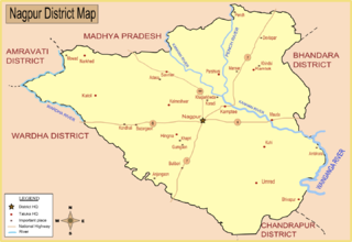
Bhiwapur is a town and a tehsil in Umred subdivision of Nagpur district in Nagpur revenue Division in the Berar region in the state of Maharashtra, India. Bhiwapur city had a gram panchayat and 2015 it became a Nagar Panchayat. Mr Lav Parmanand Janbandhu (INC) became the first President of Bhiwapur Nagar Panchayat and Mr Shankar Rajeram Dadmal became first Vice President of Bhiwapur Nagar Panchayat and one of the Corporator Mr Balaji Shankar Dewalkar was winning Election by one side voting. He won the election by lot of difference.
Atpadi is an administrative town of the Atpadi Taluka of Sangli District in the Indian state of Maharashtra. Atpadi is located north-east of Sangli District and shares borders with the adjacent Solapur and Satara Districts. The town has a taluka administrative office, a courthouse, a police station, a government-run primary hospital, various schools and colleges and a theater. Atpadi's economy is based on the cultivation and sale of agricultural products, with pomegranates and cotton constituting the core of the industry. The town is also home to the Manganga Sahakari Sugar factory, a Pomegranate auction center and various small scale industries in fields such as manufacturing, processing, servicing and repairs.
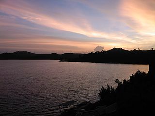
The Painganga River is the chief river of the Buldhana district, Hingoli district, Nanded district, Yavatmal district, Chandrapur district and Washim district in the Maharashtra state in India. It flows along the southeast boundaries of the district in a winding, meandering course. It is deeply entrenched and difficult to navigate. It rises in the Ajantha range and is a major tributary of the Wardha River, the other major river in the district. It is also divided Marathwada and Vidarbha near Umarkhed and Himayatnagar.
Arni is a town with & tehsil in Yavatmal district of Maharashtra State in India. It is situated on the banks of the Arunavati River. It Connected with National Highway-361. Nearest Railway Station is a Dhamangaon which is located 90 km approx & Nearest Airport is a Dr.Babasaheb Ambedkar International Airport, Nagpur is around 187 km from Arni.
Sakri is a Town/tehsil in Sakri Taluka of Dhule District of Maharashtra state in India. Headquarters for the taluka is the town of Sakri. In Sakri Taluka there is a large town named Pimpalner that has historical importance. Pimpalner hosts a religious fair in the name of Khandoji Maharaj, every year during the time of the Ganesh Festival in the month of Bhadra. Pimpalner is located alongside the Panzara River, which is the lifeline of Dhule District.

