Marengo, Ohio

Last updated

Marengo, Ohio
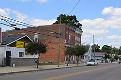
Main south of Williams, Marengo.jpg
Main Street downtown
OHMap-doton-Marengo.png
Location of Marengo, Ohio
Map of Morrow County Ohio Highlighting Marengo Village.png
Location of Marengo in Morrow County
Coordinates: 40°24′03″N82°48′40″W / 40.40083°N 82.81111°W / 40.40083; -82.81111
Country United States
State Ohio
County Morrow
Township Bennington
Government
  Type Mayor-council
Area
[1]
  Total0.17 sq mi (0.44 km2)
  Land0.17 sq mi (0.44 km2)
  Water0.00 sq mi (0.00 km2)
Elevation
[2]
1,158 ft (353 m)
Population
 (2020)
  Total283
  Density1,684.52/sq mi (648.98/km2)
Time zone UTC-5 (Eastern (EST))
  Summer (DST) UTC-4 (EDT)
ZIP code
43334
Area code 419
FIPS code 39-47558 [3]
GNIS feature ID2399254 [2]

Marengo is a village in Morrow County, Ohio, United States. The population was 283 at the 2020 census. Marengo is south of Mount Gilead, the county seat.

Contents

History

Marengo was platted in 1873, although there had been permanent settlement at the site since the 1840s. [4] A post office called Marengo was established in 1848. [5]

Geography

Marengo is considered to be a part of "Central Ohio".

According to the United States Census Bureau, the village has a total area of 0.17 square miles (0.44 km2), all of it land. [6]

Demographics

Historical population
CensusPop.Note
1880 91
1890 276203.3%
1900 242−12.3%
1910 28316.9%
1920 267−5.7%
1930 225−15.7%
1940 27522.2%
1950 2750.0%
1960 32116.7%
1970 3302.8%
1980 329−0.3%
1990 39319.5%
2000 297−24.4%
2010 34215.2%
2020 283−17.3%
U.S. Decennial Census [7]

2010 census

As of the census [8] of 2010, there were 342 people, 133 households, and 92 families living in the village. The population density was 2,011.8 inhabitants per square mile (776.8/km2). There were 148 housing units at an average density of 870.6 per square mile (336.1/km2). The racial makeup of the village was 95.3% White, 1.2% from other races, and 3.5% from two or more races. Hispanic or Latino of any race were 1.5% of the population.

There were 133 households, of which 42.9% had children under the age of 18 living with them, 40.6% were married couples living together, 19.5% had a female householder with no husband present, 9.0% had a male householder with no wife present, and 30.8% were non-families. 25.6% of all households were made up of individuals, and 12.8% had someone living alone who was 65 years of age or older. The average household size was 2.57 and the average family size was 3.08.

The median age in the village was 31.8 years. 31% of residents were under the age of 18; 8.4% were between the ages of 18 and 24; 27.1% were from 25 to 44; 22.9% were from 45 to 64; and 10.5% were 65 years of age or older. The gender makeup of the village was 48.0% male and 52.0% female.

2000 census

As of the census [3] of 2000, there were 297 people, 114 households, and 80 families living in the village. The population density was 1,668.8 inhabitants per square mile (644.3/km2). There were 120 housing units at an average density of 674.3 per square mile (260.3/km2). The racial makeup of the village was 95.96% White, 0.34% Asian, 0.34% from other races, and 3.37% from two or more races. Hispanic or Latino of any race were 0.67% of the population.

There were 114 households, out of which 41.2% had children under the age of 18 living with them, 48.2% were married couples living together, 11.4% had a female householder with no husband present, and 29.8% were non-families. 21.9% of all households were made up of individuals, and 5.3% had someone living alone who was 65 years of age or older. The average household size was 2.61 and the average family size was 3.05.

In the village, the population was spread out, with 29.6% under the age of 18, 10.8% from 18 to 24, 31.3% from 25 to 44, 19.9% from 45 to 64, and 8.4% who were 65 years of age or older. The median age was 31 years. For every 100 females there were 95.4 males. For every 100 females age 18 and over, there were 97.2 males.

The median income for a household in the village was $35,625, and the median income for a family was $47,000. Males had a median income of $33,125 versus $21,528 for females. The per capita income for the village was $14,768. About 3.5% of families and 9.2% of the population were below the poverty line, including 6.3% of those under the age of eighteen and none of those 65 or over.
Related Research Articles

<span class="mw-page-title-main">Morrow County, Ohio</span> County in Ohio, United States

Morrow County is a county located in the central portion of the U.S. state of Ohio. As of the 2020 census, the population was 34,950. Its county seat is Mount Gilead. The county was organized in 1848 from parts of four neighboring counties and named for Jeremiah Morrow who was the Governor of Ohio from 1822 to 1826. Shawnee people used the area for hunting purposes before white settlers arrived in the early 19th century.

<span class="mw-page-title-main">Marengo, Indiana</span> Town in Indiana, United States

Marengo is a town in Liberty Township, Crawford County, Indiana, United States. The population was 829 at the 2020 census. One of the tourist attractions and sources of revenue for the town is Marengo Cave, a U.S. National Landmark.

<span class="mw-page-title-main">Aberdeen, Ohio</span> Village in Ohio, United States

Aberdeen is a village in Huntington Township, Brown County, Ohio, United States, along the Ohio River 50 miles (80 km) southeast of Cincinnati. The population was 1,515 at the 2020 census.

<span class="mw-page-title-main">Warsaw, Ohio</span> Village in Ohio, United States

Warsaw is a village in Coshocton County, Ohio, United States, along the Walhonding River. The population was 624 at the 2020 census.

<span class="mw-page-title-main">Brice, Ohio</span> Village in Ohio, United States

Brice is a village in Franklin County, Ohio, United States, on the southeast side of the Columbus metropolitan area. The population was 93 at the 2020 census.

<span class="mw-page-title-main">Lyons, Ohio</span> Village in Ohio, United States

Lyons is a village in Fulton County, Ohio, United States. The population was 602 at the 2020 census.

<span class="mw-page-title-main">Addyston, Ohio</span> Village in Ohio, United States

Addyston is a village in Miami Township, Hamilton County, Ohio, United States. Located along the Ohio River, it is a western suburb of the neighboring city of Cincinnati. The population was 927 at the 2020 census.

<span class="mw-page-title-main">Cleves, Ohio</span> City in Ohio, United States

Cleves is a village in Miami Township, Hamilton County, Ohio, United States. Located along the Ohio River, it is a western suburb of Cincinnati. The population was 3,414 at the 2020 census.

<span class="mw-page-title-main">Evendale, Ohio</span> Village in Ohio, United States

Evendale is a village in Hamilton County, Ohio, United States, within the Cincinnati metropolitan area. The population was 2,669 at the 2020 census.

<span class="mw-page-title-main">Hanover, Ohio</span> Village in Ohio, United States

Hanover is a village in Licking County, Ohio, United States. The population was 1,270 at the 2020 census. The village lies along Ohio State Route 16.

<span class="mw-page-title-main">Cardington, Ohio</span> Village in Ohio, United States

Cardington is a village in Morrow County, Ohio, United States. The population was 2,051 at the 2020 census. Mount Gilead, Ohio, the county seat, is located northeast of Cardington on U.S. Route 42.

<span class="mw-page-title-main">Chesterville, Ohio</span> Village in Ohio, United States

Chesterville is a village in Morrow County, Ohio, United States, along the Kokosing River. The population was 191 at the 2020 census. Chesterville is southeast of Mount Gilead, the county seat.

<span class="mw-page-title-main">Edison, Ohio</span> Village in Ohio, United States

Edison is a village in Morrow County, Ohio, United States. The population was 422 at the 2020 census. Edison is adjacent to and west of Mount Gilead, Ohio, the county seat.

<span class="mw-page-title-main">Fulton, Ohio</span> Village in Ohio, United States

Fulton is a village in Morrow County, Ohio, United States. The population was 250 at the 2020 census. Fulton is south of Mount Gilead, the county seat.

<span class="mw-page-title-main">Sparta, Ohio</span> Village in Ohio, United States

Sparta is a village in Morrow County, Ohio, United States. The population was 121 at the 2020 census. Sparta is southeast of Mount Gilead, the county seat.

<span class="mw-page-title-main">Cloverdale, Ohio</span> Village in Ohio, United States

Cloverdale is a village in Perry Township, Putnam County, Ohio, United States. The population was 170 at the 2020 census.

<span class="mw-page-title-main">Port Washington, Ohio</span> Village in Ohio, United States

Port Washington is a village in Tuscarawas County, Ohio, United States. The population was 548 at the 2020 census.

<span class="mw-page-title-main">Morrow, Ohio</span> Village in Ohio, United States

Morrow is a village in Salem Township, Warren County, Ohio, United States. The population was 2,049 at the 2020 census.

<span class="mw-page-title-main">Risingsun, Ohio</span> Village in Ohio, United States

Risingsun is a village in Wood County, Ohio, United States. The population was 541 at the 2020 census.

<span class="mw-page-title-main">Gratiot, Ohio</span> Village in Ohio, United States

Gratiot is a village in Licking and Muskingum counties in the U.S. state of Ohio. The population was 215 at the 2020 census.

References

  1. "ArcGIS REST Services Directory". United States Census Bureau. Retrieved September 20, 2022.
  2. 1 2 U.S. Geological Survey Geographic Names Information System: Marengo, Ohio
  3. 1 2 "U.S. Census website". United States Census Bureau . Retrieved January 31, 2008.
  4. Baughman, Abraham J.; Bartlett, Robert Franklin (1911). History of Morrow County, Ohio: A Narrative Account of Its Historical Progress, Its People, and Its Principal Interests. Lewis Publishing Company. p.  380.
  5. "Morrow County". Jim Forte Postal History. Retrieved December 15, 2015.
  6. "US Gazetteer files 2010". United States Census Bureau. Archived from the original on January 25, 2012. Retrieved January 6, 2013.
  7. "Census of Population and Housing". Census.gov. Retrieved June 4, 2015.
  8. "U.S. Census website". United States Census Bureau . Retrieved January 6, 2013.