
The University of Bridgeport is a private university in Bridgeport, Connecticut. The university is accredited by the New England Commission of Higher Education. In 2021, the university was purchased by Goodwin University; it retained its own name, brand, and board of trustees.
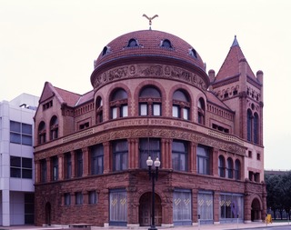
The Barnum Museum is a museum at 820 Main Street in Bridgeport, Connecticut, United States. It has an extensive collection related to P. T. Barnum and the history of Bridgeport, and is housed in a historic building on the National Register of Historic Places.

The history of Bridgeport, Connecticut was, in the late 17th and most of the 18th century, one of land acquisitions from the native inhabitants, farming and fishing. From the mid-18th century to the mid-19th century, Bridgeport's history was one of shipbuilding, whaling and rapid growth. Bridgeport's growth accelerated even further from the mid-19th century to the mid-20th century with the advent of the railroad, Industrialization, massive immigration, labor movements until, at its peak population in 1950, Bridgeport with some 159,000 people was Connecticut's second most populous city. In the late 20th century, Bridgeport's history was one of deindustrialization and declining population, though it overtook Hartford as the state's most populous city by 1980.
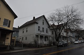
The Sterling Hill Historic District in Bridgeport, Connecticut is a historic district that was listed on the National Register of Historic Places in 1992. The district is a two-block area of 43 urban residential structures dating as far back as 1821. Most of the buildings are from later in the 19th century when the neighborhood was largely occupied by Irish working-class residents. Most of the early buildings are vernacular wood-frame structures with modest Federal, Greek Revival, or Gothic Revival details, while the later additions include multiunit tenement-style buildings. The area includes the oldest urbanized part of the city.
Bridgeport is the most populous city in the U.S. state of Connecticut and the fifth-most populous city in New England, with a population of 148,654 in 2020. Located in eastern Fairfield County at the mouth of the Pequonnock River on Long Island Sound, it is a port city 60 miles (97 km) from Manhattan and 40 miles (64 km) from The Bronx. It borders the towns of Trumbull to the north, Fairfield to the west, and Stratford to the east. Bridgeport and other towns in Fairfield County make up the Greater Bridgeport Planning Region, as well as the Bridgeport–Stamford–Norwalk–Danbury metropolitan statistical area, the second largest metropolitan area in Connecticut. The Bridgeport–Stamford–Norwalk–Danbury metropolis forms part of the New York metropolitan area.

Bassickville Historic District is a historic district encompassing a well-preserved late 19th-century residential development on the west side of Bridgeport, Connecticut. Located on Bassick, Howard, and Fairview Avenues, the area was developed as a residential subdivision of worker housing by Edmund Bassick. The development is characterized by nearly identical 1-1/2 story frame cottages exhibiting the Stick style of architecture. The district was listed on the National Register of Historic Places in 1987.
The Greenwood Avenue Historic District encompasses the historic commercial village center of Bethel, Connecticut. Extending along Greenwood Avenue from P.T. Barnum Square to Depot Place, the district includes a variety of commercial and residential architecture from the mid-19th to early 20th centuries. The district was listed on the National Register of Historic Places in 1999.
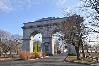
Seaside Park, located in Bridgeport, Connecticut, is a 2.5-mile (4.0 km) long crescent-shaped park bordering Bridgeport Harbor, Long Island Sound, and Black Rock Harbor. The park lies within Bridgeport's South End neighborhood.

The Bridgeport Downtown South Historic District encompasses the historic elements of the southern part of downtown Bridgeport, Connecticut. It is 27 acres (11 ha) in size, roughly bordered on the east by Main and Middle Streets, on the north by Elm Street, the west by Broad Street, and the south by Cesar Batalla Way. This area includes the highest concentration of buildings developed in the commercial downtown between about 1840 and the 1930s, the period of the city's major growth as a manufacturing center, and includes a diversity of architectural styles representative of that time period. The district was listed on the National Register of Historic Places in 1987.

The Barnum–Palliser Historic District is a 5.9-acre (2.4 ha) residential historic district in Bridgeport, Connecticut. The area, bounded roughly by Austin Street, Myrtle Avenue, Atlantic Street, and Park Avenue, was developed by P.T. Barnum to provide worker housing in the 1880s. Many of the houses were designed by Palliser, Palliser & Co., and are interesting examples of Italianate, Queen Anne, and Stick/Eastlake architecture. The district was listed on the National Register of Historic Places in 1982.

The Hotel Beach, also known historically as the Hotel Barnum, is a historic hotel building at 140 Fairfield Ave. in Bridgeport, Connecticut. It is a thirteen-story Art Deco tower built in 1927 and designed by Thomas, Martin & Kirkpatrick. It is one of the city's outstanding Art Deco buildings, built when the city was at its peak. It was listed on the National Register of Historic Places in 1978. It is a contributing building in the Bridgeport Downtown North Historic District, NRHP-listed in 1987. It is currently a residential apartment building called Barnum House.

Bridgeport, Connecticut is a major city of Connecticut located on Long Island Sound at the mouth of the Pequonnock River.

Historic Seaside Village Co-operative encompasses a primarily residential area in the South End of Bridgeport, Connecticut. It is bounded on the east by Iranistan Avenue, the north by South Avenue, the south by Forest Court and by the west by Alsace Street. The property consists of a densely built collection of brick rowhouses, arranged in irregular combinations. The village was developed during World War I to alleviate a housing shortage caused by an influx of workers hired to work in the city's munitions factories. It is a good example of an early government-funded project of this type, and was a collaborative design effort by R. Clipston Sturgis, Skinner & Walker, and Arthur Shurtleff. The district was listed on the National Register of Historic Places in 1990.

The Benedict-Miller House is a historic house at 32 Hillside Avenue in Waterbury, Connecticut. Built in 1879, it is one of the city's finest surviving examples of Queen Anne architecture, designed by Palliser, Palliser & Co. for one of the city's leading industrialists. It was listed on the National Register of Historic Places in 1981. The house is now part of the campus of the Yeshiva K'tana.

The Deacon's Point Historic District encompasses a historic 19th-century residential area of eastern Bridgeport, Connecticut. Roughly bounded by Seaview Avenue and Williston, Bunnell and Deacon Streets, the district was first laid out for development shortly after the American Civil War, and contains modest examples of residential architecture dating from 1866 to the early 20th century. The district was listed on the National Register of Historic Places in 1992.

The Division Street Historic District encompasses one of the best-preserved 19th-century residential areas of Bridgeport, Connecticut. Now separated from downtown Bridgeport by the Connecticut Route 25 highway, the area includes a cross-section of 19th-century architectural styles, as well as a diversity of sophistication, from working-class accommodations to high-style Victorian mansions. The district was listed on the National Register of Historic Places in 1982.

The East Bridgeport Historic District encompasses one of the best-preserved 19th-century neighborhoods of Bridgeport, Connecticut. Bounded by Arctic Street, East Main Street, the railroad tracks, and the Pequonnock River, this area was a planned development of Bridgeport promoter P.T. Barnum and landowner William H. Noble. Its development prompted the significant growth of industry and economic activity east of the Pequonnock River. The district was listed on the National Register of Historic Places in 1979.

The East Main Street Historic District encompasses a well-preserved late 19th-century commercial area on the east side of Bridgeport, Connecticut. Extending along East Main Street from Interstate 95 to Crescent Place, the district arose as part of a major development push orchestrated by P.T. Barnum in the 1850s, and contains one of Connecticut's finest assemblages of late Victorian commercial architecture. The district was listed on the National Register of Historic Places in 1985.

The Remington Village Historic District encompasses a World War I-era housing development in northeastern Bridgeport, Connecticut. Located on Willow Street and East Avenue between Boston and Barnum Avenues, the area was developed by the Remington Arms company to attract workers to its nearby munitions factory. The complex is a well-preserved example of wartime housing in the city, and was listed on the National Register of Historic Places in 1990.

The Stratfield Historic District is a historic residential area on the west side of Bridgeport, Connecticut. In the late 19th and early 20th century, it was one of the highest-status and most fashionable neighborhoods in the city. At more than 100 acres (40 ha) in size, it is one of the largest assemblages of high-status residential architecture in the state. It was listed on the National Register of Historic Places in 1980.


