Yosemite National Park is an American national park in California, surrounded on the southeast by Sierra National Forest and on the northwest by Stanislaus National Forest. The park is managed by the National Park Service and covers an area of 759,620 acres in four counties – centered in Tuolumne and Mariposa, extending north and east to Mono and south to Madera County. Designated a World Heritage Site in 1984, Yosemite is internationally recognized for its cliffs, waterfalls, clear streams, giant sequoia groves, lakes, mountains, meadows, glaciers, and biological diversity. Almost 95 percent of the park is designated wilderness. Yosemite is one of the largest and least fragmented habitat blocks in the Sierra Nevada, and the park supports a diversity of plants and animals.
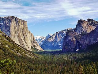
Yosemite Valley is a glacial valley in Yosemite National Park in the western Sierra Nevada mountains of Central California. The valley is about 7.5 mi (12.1 km) long and 3,000–3,500 ft (910–1,070 m) deep, surrounded by high granite summits such as Half Dome and El Capitan, and densely forested with pines. The valley is drained by the Merced River, and a multitude of streams and waterfalls flow into it, including Tenaya, Illilouette, Yosemite and Bridalveil Creeks. Yosemite Falls is the highest waterfall in North America and is a big attraction especially in the spring, when the water flow is at its peak. The valley is renowned for its natural environment and is regarded as the centerpiece of Yosemite National Park.

Mariposa County is a county located in the U.S. state of California. As of the 2020 U.S. Census, the population was 17,131. The county seat is Mariposa. It is located in the western foothills of the Sierra Nevada mountains, north of Fresno, east of Merced, and southeast of Stockton.

Tuolumne County, officially the County of Tuolumne, is a county located in the U.S. state of California. As of the 2020 census, the population was 55,620. The county seat and only incorporated city is Sonora.

Mariposa is an unincorporated community and census-designated place (CDP) in and the county seat of Mariposa County, California, United States. The population was 1,526 at the 2020 census. The community is named after the flocks of monarch butterflies seen overwintering there by early explorers.

Wawona is a census-designated place in Mariposa County, California, United States. The population was 111 at the 2020 census.
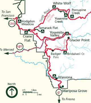
Mariposa Grove is a sequoia grove located near Wawona, California, United States, in the southernmost part of Yosemite National Park. It is the largest grove of giant sequoias in the park, with several hundred mature examples of the tree. Two of its trees are among the 30 largest giant sequoias in the world. The grove closed on July 6, 2015, for a restoration project and reopened on June 15, 2018.

Human habitation in the Sierra Nevada region of California reaches back 8,000 to 10,000 years ago. Historically attested Native American populations, such as the Sierra Miwok, Mono and Paiute, belong to the Uto-Aztecan and Utian phyla. In the mid-19th century, a band of Native Americans called the Ahwahnechee lived in Yosemite Valley. The California Gold Rush greatly increased the number of non-indigenous people in the region. Tensions between Native Americans and white settlers escalated into the Mariposa War. As part of this conflict, settler James Savage led the Mariposa Battalion into Yosemite Valley in 1851, in pursuit of Ahwaneechees led by Chief Tenaya. The California state military forces burned the tribe's villages, destroyed their food stores, killed the chief's sons, and forced the tribe out of Yosemite. Accounts from the Mariposa Battalion, especially from Dr. Lafayette Bunnell, popularized Yosemite Valley as a scenic wonder.

The Ahwahnechee are a Native American people who traditionally lived in the Yosemite Valley and still live in surrounding area. They are the seven tribes of Yosemite Miwok, Northern Paiute, Kucadikadi Mono Lake people. As one of the most documented tribes the tribe still fights for Federal Recognition. The Ahwahnechee people's heritage can be found all over Yosemite National Park.

State Route 49 is a north–south state highway in the U.S. state of California that passes through many historic mining communities of the 1849 California gold rush and it is known as the Golden Chain Highway. The highway's creation was lobbied by the Mother Lode Highway Association, a group of locals and historians seeking a single highway connect many relevant locations along the Gold Rush to honor the 49ers. One of the bridges along SR 49 is named for the leader of the association, Archie Stevenot.

Galen Clark was a Canadian-born American conservationist and writer. He is known as the first European American to discover the Mariposa Grove of Giant Sequoia trees, and is notable for his role in gaining legislation to protect it and the Yosemite area, and for 24 years serving as Guardian of Yosemite National Park.
Keyesville is an unincorporated community in Kern County, California. It is located 2 miles (3.2 km) west of Lake Isabella and the Kern River Valley, at an elevation of 2,848 feet (868 m). Keyesville, founded in 1854 is named for Richard M. Keyes, whose discovery of gold in 1853 started the Kern River Gold Rush.

The Wawona Hotel is a historic hotel located within southern Yosemite National Park, in California. It was declared a National Historic Landmark in 1987, and is on the National Register of Historic Places.
Agua Fria is an unincorporated community in Mariposa County, California. It is located 5.25 miles (8.4 km) northeast of Catheys Valley, at an elevation of 2001 feet. Agua Fria is the former county seat of Mariposa County located approximately three miles west of Mariposa, California.

Curry Village is a resort in Mariposa County, California in Yosemite National Park within the Yosemite Valley.

Gold Run was a former mining town of the California Gold Rush, located in Placer County, California.
Rancho Las Mariposas was a 44,387-acre (179.63 km2) Mexican land grant in Alta California, located in present-day Mariposa County, California.

The Yosemite Valley Bridges are eight bridges in the Yosemite Valley of Yosemite National Park, most of them spanning the Merced River. Five of them were built in 1928, with the remainder built between 1921 and 1933. The bridges feature a concrete structure faced with local stone, in an elliptical or three-centered arch configuration. They are notable for their uniform character and for their conformance to tenets of the National Park Service rustic style. Design work for the seven newer bridges was by George D. Whittle of the San Francisco District Office of the U.S. Bureau of Public Roads for the National Park Service. Concrete bridges were chosen at the urging of Thomas Chalmers Vint of the Park Service, in lieu of alternative designs for steel truss bridges, or suspension bridges suggested by the park superintendent.

The Superior Court of California, County of Colusa, also known as the Colusa County Superior Court, is the branch of the California superior court with jurisdiction over Colusa County.
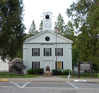
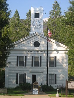
The Superior Court of California, County of Mariposa, also known as the Mariposa County Superior Court or Mariposa Superior Court, is the branch of the California superior court with jurisdiction over Mariposa County.