Putla Villa de Guerrero or simply Putla, is a town and municipality in the State of Oaxaca, Mexico. It is part of Putla District in the west of the Sierra Sur Region.

Atoyac de Álvarez is a municipality in the Mexican state of Guerrero. The municipal seat lies at Atoyac de Álvarez. The municipality covers an area of 1,638.4 km2 (632.6 sq mi).

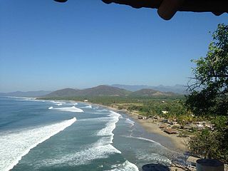
Coyuca de Benítez is a municipality in the Mexican state of Guerrero. The municipal seat lies at Coyuca de Benítez. The municipality covers an area of 1,602.9 km².

Zirándaro is a municipality in the Mexican state of Guerrero. The municipal seat lies at Zirándaro de los Chávez. The municipality covers an area of 2,475.6 km2.
Cuajinicuilapa is a municipality in the Mexican state of Guerrero. The municipal seat lies at Cuajinicuilapa. The municipality covers an area of 857.1 km². In 2020, the municipality had a total population of 26,627, up from 25,537 in 2005.

Cuautepec is a municipality in the Mexican state of Guerrero. The municipal seat lies at Cuautepec. The municipality covers an area of 414.3 km².
Eduardo Neri is a municipality in the Mexican state of Guerrero. The municipal capital is Zumpango del Río. The municipality covers an area of 1289.6 km².
General Canuto A. Neri is a municipality in the Mexican state of Guerrero. The municipal seat lies at Acapetlahuaya. The municipality covers an area of 300.4 km2.

General Heliodoro Castillo is a municipality in the southern Mexican state of Guerrero. It is located 34 kilometres from Chilpancingo, the state capital. The municipal seat lies at Tlacotepec.
Tecpan de Galeana is a municipality in the Mexican state of Guerrero. The municipal seat lies at Tecpan de Galeana. The municipality covers an area of 2,537.8 km2 (979.9 sq mi).

Tlacoachistlahuaca is a municipality in the Mexican state of Guerrero. The municipal seat lies at Tlacoachistlahuaca. The municipality covers an area of 450.6 km².
Xalpatláhuac is a municipality in the Mexican state of Guerrero. The municipal seat lies at Xalpatláhuac. The municipality covers an area of 393.6 km².
Xochihuehuetlán is a municipality in the Mexican state of Guerrero. The municipal seat lies at Xochihuehuetlán. The municipality covers an area of 191.6 km².
Huichapan is a town and one of the 84 municipalities of Hidalgo, in central-eastern Mexico. The municipality covers an area of 668.1 km2. Its name derives from the Classical Nahuatl Huēyichiyapan.

Juárez Hidalgo is a town and one of the 84 municipalities of Hidalgo, in central-eastern Mexico. Created in 1869, its name honours both Benito Juárez and Miguel Hidalgo. The present-day municipal seat was known as Itztapanitla prior to European contact and, in colonial times, as San Guillermo.
Santa María Apazco is a town and municipality in Oaxaca in south-western Mexico. It is part of the Nochixtlán District in the southeast of the Mixteca Region.
San Jerónimo Tecuanipan is a town and municipality in the Mexican state of Puebla in south-eastern Mexico. In 2020, the municipality reported a total population of 6,597, an increase of 13.2% from 2010.
San Matías Tlalancaleca is a town and municipality in the Mexican state of Puebla in south-eastern Mexico. The population of San Matias Tlalancaleca was 20,974 inhabitants in 2015.
Santa Isabel Cholula is a town and municipality in the Mexican state of Puebla in south-eastern Mexico. In 2020, the municipality reported a population of 11,498, an increase of 43% from 2010.

Tepetitla de Lardizábal is a town and its surrounding municipality in the Mexican state of Tlaxcala.

