
Mathews County is a county located in the U.S. state of Virginia. As of the 2020 census, the population was 8,533. Its county seat is Mathews.

Courtland is an incorporated town in Southampton County, Virginia, United States. It is the county seat of Southampton County.
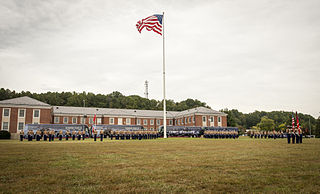
Marine Corps Base Quantico is a United States Marine Corps installation located near Triangle, Virginia, covering nearly 55,148 acres of southern Prince William County, Virginia, northern Stafford County, and southeastern Fauquier County. Used primarily for training purposes, MCB Quantico is known as the "Crossroads of the Marine Corps".
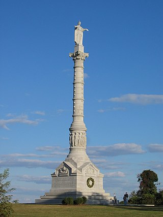
Colonial National Historical Park is a large national historical park located in the Hampton Roads region of Virginia operated by the National Park Service. It protects and interprets several sites relating to the Colony of Virginia and the history of the United States more broadly. These range from the site of the first English settlement at Jamestown, to the battlefields of Yorktown where the British Army was defeated in the American Revolutionary War. Over 3 million people visit the park each year.

Lyndon B. Johnson National Historical Park is a United States National Historical Park in central Texas about 50 miles (80 km) west of Austin in the Texas Hill Country. The park protects the birthplace, home, ranch, and grave of Lyndon B. Johnson, 36th president of the United States. During Johnson's administration, the LBJ Ranch was known as the Texas White House because the President spent approximately 20% of his time in office there.

Bluemont is an unincorporated village in Loudoun County, Virginia located at the eastern base of Snickers Gap in the Blue Ridge Mountains. The village's center is located along Snickersville Turnpike, 4 miles (6.4 km) west of the incorporated town of Round Hill. The village borders Virginia's fox hunting country and is within 1 mile (1.6 km) of the Appalachian Trail and the Bears Den and Raven Rocks formations in the Blue Ridge.

First Landing State Park offers recreational opportunities at Cape Henry in the independent city of Virginia Beach, Virginia. As the first planned state park of Virginia, First Landing is listed on the National Register of Historic Places as Seashore State Park Historic District. A portion of the park is listed as a National Natural Landmark as part of the Seashore Natural Area.

Waterford is an unincorporated village and census-designated place (CDP) in the Catoctin Valley of Loudoun County, Virginia, located along Catoctin Creek. Waterford is 47 miles (76 km) northwest of Washington, D.C., and 7 miles (11 km) northwest of Leesburg. The entire village and surrounding countryside is a National Historic Landmark District, noted for its well-preserved 18th and 19th-century character.

Aurora is an unincorporated community and census-designated place in southeastern Preston County, West Virginia, United States. As of the 2010 census, its population was 201. Aurora is located on U.S. Route 50 between the Maryland state line and the town of Rowlesburg. Cathedral State Park is located to the east of Aurora's post office.
Prices Fork is a small traditionally agricultural census-designated place (CDP), in Montgomery County, Virginia, United States. The population as of the 2010 Census was 1,066. It is located about three miles west of Blacksburg and the campus of Virginia Polytechnic Institute and State University.

Burke's Garden is an upland valley and unincorporated community in Tazewell County, Virginia.

Batesville is an unincorporated community in Albemarle County, Virginia, United States. Its elevation is 620 feet (190 m).

This is a list of the National Register of Historic Places listings in Prince William County, Virginia.

This is a list of the National Register of Historic Places listings in Mathews County, Virginia.

This is a list of the National Register of Historic Places listings in Warrick County, Indiana.
Frankford is an unincorporated community in Greenbrier County, West Virginia, United States. Frankford is located on U.S. Route 219, south of Falling Spring and north of Maxwelton. Frankford has a post office with ZIP code 24938.
The Windham Village Historic District is one of two historic districts in Windham, Vermont, encompassing the dispersed rural village near the town's geographic center. The area was principally developed in the early decades of the 19th century, and has had only modest alterations since then. It was listed on the National Register of Historic Places in 1984.
Mathews County Courthouse Square is a national historic district located at Mathews, Mathews County, Virginia. It encompasses seven contributing buildings, one contributing site, two contributing structures, and 2 contributing objects on Courthouse Square. The courthouse is a T-shaped, Federal style brick building constructed in 1792–1795. Associated with the courthouse are the clerks office (1859), the former jail and later sheriffs office, "Old Jail," and Mathews County Library (1930). Several monuments occupy the square, notably the Confederate monument, the 1928 Fort Cricket Hill monument, and a World War I cannon.

Denbigh Plantation Site, also known as Mathews Manor, is a historic archaeological site located at Newport News, Virginia.
The Dublin Village Historic District encompasses the historic village center of Dublin, New Hampshire. Dublin's center developed in the 19th century after its original village center was abandoned due to harsher winter conditions nearer Dublin Pond. The district extends along Main Street from its junction with Lake Street in the west to the junction with Old County Road in the east, and includes sections of Old Common Road, Harrisville Road, and Church Street. The district was listed on the National Register of Historic Places in 1983.


