Arequipa is a department in southwestern Peru. It is bordered by the departments of Ica, Ayacucho, Apurímac and Cusco in the north, the Department of Puno in the east, the Department of Moquegua in the south, and the Pacific Ocean in the west. Its capital, also called Arequipa, is Peru's second-largest city.

Inkallaqta is a monumental Inca site in central Bolivia. It is located in the Cochabamba Department, Carrasco Province, Pocona Municipality, approximately 130 kilometers east of Cochabamba. It was most recently excavated by Larry Coben.He believes that the site was used to perform rites for the ceremonial calendar. The site has several important structures such as the Kallanka. It was the largest single roofed room in the western hemisphere when it was built, and measures 78 by 25 meters. There's also an ushnu or a ritual platform on the site. The Torreon of Inkallaqta is also located on this site. Located at the western side of the site this six sided structure supposedly had calendrical or astronomical significance. There is a zigzag wall immediately north of the site which is meant to mark and protect it.

Llaqtapata (Quechua) llaqta place, pata elevated place / above, at the top / edge, bank, shore, pronounced 'yakta-pahta', hispanicized Llactapata) is an archaeological site about 5 km (3.1 mi) west of Machu Picchu. The complex is located in the Cusco Region, La Convención Province, Santa Teresa District, high on a ridge between the Ahobamba and Santa Teresa drainages.

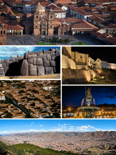
Paruro Province is one of thirteen provinces in the Cusco Region in the southern highlands of Peru.
Puyca District is one of eleven districts of the province La Unión in Peru.

Mawk'allaqta, also Mawk'a Llaqta, the architectural Inca complex, is located above the contemporary village of San Antonio, 3,700 meters above sea level, and overlooks the neighbouring valley. The nearest bigger town, Pampacolca, is located approximately 170 kilometers north-west of the city Arequipa in the southern highlands of Peru.

Patallacta, Llactapata or Q'ente Marka is an archaeological site in Peru located in the Cusco Region, Urubamba Province, Machupicchu District. It is situated southeast of the site Machu Picchu, at the confluence of the rivers Cusichaca and Vilcanota on a mountain named Patallacta.
Mawk'allaqta, also Mawk'a Llaqta is an archaeological site in Peru. It is located in the Cusco Region, Espinar Province, on the border of the districts Coporaque and Suykutambo. Mawk'allaqta is situated on the banks of the Hank'amayu and the Apurímac River at a height of 3,915 metres (12,844 ft).

Inka Wasi is an archaeological site in the Huancavelica Region in Peru. The Inca palace is considered one of the most important monuments of the Huancavelica Region. Inka Wasi is located in the Huaytará Province, Huaytará District, about 25 km from Huaytará. It is situated at a height of 3,804 m (12,480 ft).
Runkuraqay or Runku Raqay is an archaeological site on a mountain of the same name in Peru located in the Cusco Region, Urubamba Province, Machupicchu District. It is situated southeast of the archaeological site Machu Picchu and south of the Vilcanota river. The ruins lie on the southern slope of the mountain Runkuraqay near the Runkuraqay pass, northeast of the archaeological site Sayacmarca and southeast of the site Qunchamarka.
Willkawayin is an archaeological site in Peru. It is located in the Ancash Region, Huaraz Province, Independencia District, in the village of Paria. It is situated at a height of about 3,400 m (11,200 ft).
Mawk'allaqta, also Mawk'a Llaqta is an archaeological site in Peru. It is located in the Puno Region, Melgar Province, Nuñoa District. The site was declared a National Cultural Heritage (Patrimonio Cultural) of Peru by the National Institute of Culture.
Mawk'allaqta, also Mawk'a Llaqta, is an archaeological site in Peru. It is located in the Puno Region, Sandia Province, Sandia District. The site was declared a National Cultural Heritage (Patrimonio Cultural) of Peru by the National Institute of Culture.
Mawk'allaqta or Mawk'a Llaqta may refer to:
Taqrachullu, Pukara Taqrachullu, T'akrachullu, Pukara T'akrachullu or María Fortaleza is an archaeological site in Peru. It is located in the Cusco Region, Espinar Province, Suykutambo District.
Mawk'allaqta or Mawk'a Llaqta is an archaeological site in Peru. It is located in the Cusco Region, Paruro Province, Paccaritambo District, near Mullipampa (Mollebamba).
Mawk'ataray or Mawk'a Taray is an archaeological site in Peru. It is located in the Cusco Region, Calca Province, Taray District.
Llamuqa is a mountain with archaeological remains in the Andes of Peru, about 4,794 metres (15,728 ft) high. It is situated in the Arequipa Region, La Unión Province, Huaynacotas District.

Hatun K'irawniyuq is a mountain in the Arequipa Region in the Andes of Peru, about 4,731.1 metres (15,522 ft) high. It is situated in the Condesuyos Province, Salamanca District, north of the volcano Coropuna. The peak west of K'irawniyuq is named Quri Qhawana (Ccorecahuana). One of the nearest populated places is Mawk'allaqta in the northeast. The village is situated at the mountain Mawk'a Llaqta (Mauca Llacta).