
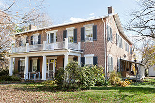
Elk Hill is a historic house and farm complex located near Nellysford, Nelson County, Virginia. Operated for more than 250 years, it is one of the earliest extant farms in Nelson County. The 173-acre (0.70 km2) rural farm bounded in part by the South Fork of the Rockfish River and Reid's Creek. The main house is a substantial two-story, three-bay wide frame dwelling with a central hall plan, with the original portion built between 1790 and 1810. Since Samuel Reid sold the farm in 1805 to Hawes Coleman (whose descendants owned it until 1977, it is unclear which family constructed the current house, particularly since the property contained the ruins of a smaller structure which was occupied into the 20th century. The house underwent a series of 19th-century additions and a major remodeling in 1902 in the neoclassical style. The property includes structures showing the succession of major crops in the area, from tobacco in the 18th and 19th centuries, to apples in the early 20th centuries. The current owner began a vineyard and winery late in the 20th century, partly on land once operated as High View Farm, as well as issued in 2005 a conservation easement to the Virginia Outdoors Foundation to protect its natural habitat and rural character. The contributing outbuildings include: smokehouse, built in the last quarter of the 18th century; tobacco barn, built circa 1790–1810; 19th century chicken house, two seat outhouse, and double crib barn; garages built in 1902 and in 1955; and a stone boundary/retaining wall, built in the last quarter of the 18th century.
Fort Hill, also known as Fort Hill Farm, is a historic plantation house and national historic district located near Burlington, Mineral County, West Virginia. The district includes 15 contributing buildings, 1 contributing site, and 2 contributing structures. The main house was completed in 1853, and is a two-story, "L"-shaped brick dwelling composed of a side gable roofed, five bay building with a rear extension in the Federal style. It features a three-bay, one-story front porch supported by four one foot square Tuscan order columns. Also on the property are a number of contributing buildings including a washhouse and cellar, outhouse, a dairy and ice house, a meat house, a garage, a hog house, poultry houses, a bank barn with silo, and a well. The family cemetery is across the road west of the main house. Located nearby and in the district is "Woodside," a schoolhouse built about 1890, and a tenant house and summer kitchen.

The Knorr–Bare Farm is an historic, American farm complex and national historic district that are located in Lower Heidelberg Township, Berks County, Pennsylvania.

The Jacob Leiby Farm is an historic American farm complex, Pennsylvania Bluestone quarry, and national historic district that are located in Perry Township, Berks County, Pennsylvania.

Clover Creek is an unincorporated community in Highland County, Virginia, United States. Clover Creek is located 10 miles (16 km) south-southeast of Monterey, Virginia, on State Route 678. The community is situated in the Bullpasture Valley along the path of the Bullpasture River. Beginning in 1897 with a decision by the United States Board on Geographic Names, the community was officially referred to as the single-word "Clovercreek"; however, in 1970, the board modified the community's name to the current two-word "Clover Creek". During the French and Indian War, a British fort named Fort George was built near Clover Creek in 1754 consisting of a wooden stockade 90 feet (27 m) square. The fort was never directly attacked, though arrows were at one point launched against the fort from a distance leaving no damage. George Washington may have visited the fort while traveling in the area, marking the only time Washington visited the region which is now known as Highland County.

Seven Oaks Farm is a historic home and farm complex located near Greenwood, Albemarle County, Virginia. It was formerly known as Clover Plains and owned by John Garrett, who assisted with building the University of Virginia and was a bursar with the university. After Dr. Garrett's death, the farm was sold to the Bowen family and inherited by the Shirley family. In 1903, it was bought by Marion Langhorne of Richmond, a relative of Chiswell Dabney Langhorne, father of the famous Gibson girls, who lived at nearby Mirador. The land is named after the original seven oak trees on the property named after the first seven presidents born in Virginia. Only one of the original seven trees still standing after six were destroyed in 1954 in the aftermath of Hurricane Hazel. The main house was built about 1847–1848, and is a two-story, five-bay, hipped-roof frame building with a three-bay north wing. The interior features Greek Revival style design details. It has a two-story, pedimented front portico in the Colonial Revival style addition. Sam Black's Tavern is a one-story, two-room, gable-roofed log house with a center chimney and shed-roofed porch. Black's Tavern has since been moved to the adjacent Mirador property circa 1989. It was originally owned by Samuel Black, a Presbyterian minister of the Sam Black Church in West Virginia. Blacksburg, Virginia, was named after the family. Other buildings on the farm include an ice house, smokehouse, dairy, greenhouse, barns, a carriage house, a garage and several residences for farm employees. The ice house on the land, typically framed in an octagonal shape, in fact only has six sides.
East Belmont is a historic farm and national historic district located near Keswick, Albemarle County, Virginia. The district encompasses 3 contributing buildings, 1 contributing site, and 1 contributing structure. The original house, now the rear ell, was built about 1811–1814, and is a two-story, three-bay, gable roofed frame structure. In 1834, a two-story, five-bay Federal style brick structure was added as the main house. A one-story, glass sunroom was added in the 1960s. The front facade features a two-story, pedimented portico. Also on the property are a contributing 19th-century corncrib, early 20th-century stone and frame barn, and an early 20th-century henhouse.

Greyledge is a historic home and national historic district in Botetourt County, Virginia. It encompasses 13 contributing buildings, 2 contributing sites, and 2 contributing structures, as well as woods and cropland. Although less than a mile from Interstate 81, the house seated on a knob 1200 feet in altitude is not visible from the interstate highway, nor is the highway visible from the house. Purgatory Mountain is visible to the west of the house, which has views of the Blue Ridge Mountains to the south and east. Purgatory Creek drains much of the property and flows into the James River several miles south in the town of Buchanan.

Long Marsh Run Rural Historic District is a national historic district located just outside Berryville, in Clarke County, Virginia. It encompasses 315 contributing buildings, 16 contributing sites, and 35 contributing structures. The district includes the agricultural landscape and architectural resources of an area distinctively rural that contains numerous large antebellum and postbellum estates, and several smaller 19th-century farms, churches, schools and African-American communities.

Burrland Farm Historic District is a historic home and farm complex and national historic district located near Middleburg, Fauquier County, Virginia. The district encompasses 22 contributing buildings, 2 contributing sites, 14 contributing structures, and 1 contributing object on a 458-acre thoroughbred horse breeding and training farm. The buildings were built between 1927 and 1932, and include a Georgian Revival style training barn, a polo barn, a stallion barn, two broodmare barns, a yearling barn, a field shed, an equipment shed, a farm manager's house / office, a trainer's cottage, a mess hall quarters, a foreman's dwelling, three mash houses, five garages, a pumphouse, and a feed and storage warehouse. The contributing structures include a silo, a springhouse, three loading chutes, two teasing chutes, two rings, three run-in sheds, one sun hut and an entrance gate. The original Burrland house was built in 1879 and expanded in 1927 for William Ziegler Jr. by architect William Lawrence Bottomley. Ziegler sold the property in 1955 to Eleonora Sears, who "deliberately gutted and burned [the mansion] down" in 1961. She then sold the farm in 1966.
Green Pastures is a historic home and farm complex and national historic district located near Middleburg, Fauquier County, Virginia. Recognized as having been owned by industrialist and financier Robert Earll McConnell, the district encompasses 13 contributing buildings built between 1931 and 1947. The include a Colonial Revival style manor house inspired by Mount Vernon, a smokehouse, stable, hostlers' quarters, farmer's cottage, garage and cow shed, chicken house and cow barn designed by New York architect Penrose V. Stout and built between 1931 and 1932; a stone sheep shed, a masonry workshop, a metal machine shed and log cabin built between 1935 and 1947. The frame manor house consist of a 2+1⁄2-story, seven-bay central section flanked by hyphens connected to two-story flanking wings.

Ben Dover, also known as Ben Dover Farm, is a historic home and plantation complex, recognized as a national historic district, located near Manakin-Sabot in Goochland County, Virginia, United States. The district encompasses 13 contributing buildings, 8 contributing sites, and 10 contributing structures.

Rochambeau Farm is a historic home and farm complex located near Manakin-Sabot, Goochland County, Virginia. The main dwelling was built about 1855, and is an L-shaped full two-story frame structure set on a common bond brick foundation in the Greek Revival style. It has a low hip roof and three single-story colonnade porches.

Meadow Grove Farm is a historic farm complex and national historic district located at Amissville, Rappahannock County, Virginia. It encompasses 13 contributing buildings and 5 contributing sites. The main house was constructed in four distinct building phases from about 1820 to 1965. The oldest section is a 1 1/2-story log structure, with a two-story Greek Revival style main block added about 1860. A two-story brick addition, built in 1965, replaced a two-story wing added in 1881. In addition to the main house the remaining contributing resources include a tenant house/slave quarters, a schoolhouse, a summer kitchen, a meat house, a machine shed, a blacksmith shop, a barn, a chicken coop, a chicken house, two granaries, and a corn crib; a cemetery, an icehouse ruin, two former sites of the present schoolhouse, and the original site of the log granary.

Kennedy–Lunsford Farm is a historic home, farm, and national historic district located near Lexington, Rockbridge County, Virginia. The district encompasses six contributing buildings. They are the main house, plus a large bank barn, a corn crib / machinery shed, a spring house, a chicken coop and a syrup house, all dating from the early-20th century. The main house is a two-story, three-bay, vernacular Georgian style stone dwelling with a gable roof and interior end chimneys. It has a single bay, gable roofed front porch and two-story rear frame ell.

John K. Beery Farm is a historic home and farm complex located near Edom, Virginia, United States. The main house dates to 1838, and consists of a two-story, five-bay, central-hall plan, main section with a one-story, three-bay east wing. The main section measures 50 feet wide and 18 feet deep and features a long one-story, late-19th century porch. Also on the property are a number of contributing outbuildings including a stone bank barn, loom house, spring house, wash house / kitchen, granary, sheds, and an outhouse. The meeting room in the east wing of the house served a large congregation of Mennonites for a number of years. John K. Berry was a descendant of Swiss settlers in Pennsylvania.

Smithfield is a historic home and farm and national historic district located near Rosedale in Russell County, Virginia, United States. The district encompasses 13 contributing buildings and 5 contributing sites. The main house dates to the 1850s, and is a two-story, five-bay, central passage plan, brick Greek Revival style dwelling. Among the other buildings in the district are a brick spring house, a brick acetylene house, frame meat house, a former school house, frame horse barn, frame sheep barn, cow barn, a milking parlor, and a shop. The contributing sites include an earlier house seat, three cemeteries, and the site of a slave house.

Bowman–Zirkle Farm, also known as the Isaiah Bowman Farm, is a historic home and farm and national historic district located near Edinburg, Shenandoah County, Virginia. The district encompasses seven contributing buildings and three contributing structures. The farmhouse was built in 1879, and is a two-story, three-bay, frame I-house dwelling with an integral wing. The remaining contributing resources are a 19th-century log-and-frame tenant house, a summer kitchen, frame meat house, a large bank barn ; a barn shed, a second bank barn, a frame granary, a wood-stave silo, and a large, two-story chicken house.

Maiden Spring is a historic home and farm complex and national historic district located at Pounding Mill, Tazewell County, Virginia. The district encompasses eight contributing buildings, two contributing sites, and one contributing structure. The main house consists of a large two-story, five-bay, frame, central-passage-plan dwelling with an earlier frame dwelling, incorporated as an ell. Also on the property are the contributing meat house, slave house, summer kitchen, horse barn, the stock barn, the hen house, the granary / corn crib, the source of Maiden Spring, the cemetery, and the schoolhouse. It was the home of 19th-century congressman, magistrate and judge Rees Bowen (1809–1879) and his son, Henry (1841-1915), also a congressman. During the American Civil War, Confederate Army troops camped on the Maiden Spring Farm.
Watkins Family Farm Historic District, also known as Lakeland Farm, is a historic home and farm and national historic district located near Raymore, Cass County, Missouri. The farm includes 18 contributing buildings, three contributing sites, and 21 contributing structures dated between about 1868 and 1957. They include three residential buildings, eight barns, three machine and implement sheds, four wells, ten dams and ponds, and a number of ancillary structures such as a milk house, a pump house, an outhouse, a silo, two corn bins, two chicken coops, three cattle feeder structures, and a cattle loading ramp. The Allen-Watkins Residence was built in 1913, and is a 2+1⁄2-story, Prairie School style frame dwelling built from the Sears and Roebuck Company prefabricated kit for Sears House Plan #227, "The Castleton."


