Related Research Articles

Devils Tower is a butte, possibly laccolithic, composed of igneous rock in the Bear Lodge Ranger District of the Black Hills, near Hulett and Sundance in Crook County, northeastern Wyoming, above the Belle Fourche River. It rises 1,267 feet (386 m) above the Belle Fourche River, standing 867 feet (264 m) from summit to base. The summit is 5,112 feet (1,558 m) above sea level.

Black Elk Peak is the highest natural point in the U.S. state of South Dakota and the Midwestern United States. It lies in the Black Elk Wilderness area, in southern Pennington County, in the Black Hills National Forest. The peak lies 3.7 mi (6.0 km) west-southwest of Mount Rushmore. At 7,244 feet (2,208 m), it is the highest summit in the United States east of the Rocky Mountains. Though part of the North American Cordillera, it is generally considered to be geologically separate from the Rocky Mountains.

Hueco Tanks is an area of low mountains and historic site in El Paso County, Texas, in the United States. It is located in a high-altitude desert basin between the Franklin Mountains to the west and the Hueco Mountains to the east. Hueco is a Spanish word meaning hollows and refers to the many water-holding depressions in the boulders and rock faces throughout the region. Due to the unique concentration of historic artifacts, plants and wildlife, the site is under protection of Texas law; it is a crime to remove, alter, or destroy them.
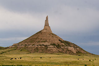
Chimney Rock is a prominent geological rock formation in Morrill County in western Nebraska. Rising nearly 300 feet (91 m) above the surrounding North Platte River valley, the peak of Chimney Rock is 4,228 feet (1,289 m) above sea level. The formation served as a landmark along the Oregon Trail, the California Trail, and the Mormon Trail during the mid-19th century. The trails ran along the north side of the rock, which remains a visible landmark for modern travelers along U.S. Route 26 and Nebraska Highway 92. Chimney Rock National Historic Site was designated in 1956 and is an affiliated area of the National Park Service, operated by History Nebraska. Chimney Rock was added to the National Register of Historic Places on October 15, 1966.

Bear Butte is a geological laccolith feature located near Sturgis, South Dakota, United States, that was established as a State Park in 1961. An important landmark and religious site for the Plains Indians tribes long before Europeans reached South Dakota, Bear Butte is called Matȟó Pahá, or Bear Mountain, by the Lakota, or Sioux. To the Cheyenne, it is known as Noahȧ-vose or Náhkȯhe-vose, and is the place where Ma'heo'o imparted to Sweet Medicine, a Cheyenne prophet, the knowledge from which the Cheyenne derive their religious, political, social, and economic customs.

Pipestone National Monument is located in southwestern Minnesota, just north of the city of Pipestone, Minnesota. It is located along the highways of U.S. Route 75, Minnesota State Highway 23 and Minnesota State Highway 30. The quarries are sacred to many tribal nations of North America, including the Dakota, Lakota, and other tribes of Native Americans, and were considered neutral territory in the historic past where all Nations could quarry stone for ceremonial pipes. The catlinite, or "pipestone", is traditionally used to make ceremonial pipes, vitally important to traditional Plains Indian religious practices. Archeologists believe the site has been in use for over 3000 years with Minnesota pipestone having been found inside North American burial mounds dated much earlier.

The Jeffers Petroglyphs site is an outcrop in southwestern Minnesota with pre-contact Native American petroglyphs. The petroglyphs are pecked into rock of the Red Rock Ridge, a 23-mile (37 km)-long Sioux quartzite outcrop that extends from Watonwan County, Minnesota to Brown County, Minnesota. The exposed surface is approximately 150 by 650 feet and surrounded by virgin prairie. "The site lies in an area inhabited in the early historic period by the Dakota Indians, and both the style and form of some of the carvings are identical with motifs that appear on Dakota hide paintings and their quill designs and beadwork. Others are foreign to this Plains Indian tradition and seem to be much earlier in origin." Several old wagon trail ruts traverse the site, one of which is believed to be the old stage coach route from New Ulm, Minnesota to Sioux Falls, South Dakota.

Courthouse and Jail Rocks are two rock formations located near Bridgeport in the Nebraska Panhandle.

The National Register of Historic Places in the United States is a register including buildings, sites, structures, districts, and objects. The Register automatically includes all National Historic Landmarks as well as all historic areas administered by the U.S. National Park Service. Since its introduction in 1966, more than 90,000 separate listings have been added to the register.
Upper Sioux Agency, was a federal administrative center established in response to treaties with the Dakota people in what became Yellow Medicine County, Minnesota, United States. Located on the Minnesota River south of Granite Falls, Minnesota, the government-run campus of employee housing, warehouses and a manual labor school was destroyed in the Dakota War of 1862. The grave of Chief Walking Iron Mazomani, a leader of the Wahpetonwan Dakota tribes, who was killed during the 1862 Dakota War's Battle of Wood Lake, is here. The site was listed on the National Register of Historic Places in 1970 for having state-level significance under the themes of archaeology, architecture, education, and social history. Established as a Minnesota state park in the 60s, the park is being closed and transferred to the tribal members of the Upper Sioux Community. State Route 67, that traverses through the park, was closed after failing deep underground. The highway would require expensive repairs along with the bridge over the Yellow Medicine River that has been compressed by the movement so much that it needs to be removed or replaced.

This is a list of properties and historic districts in the U.S. state of South Dakota that are listed on the National Register of Historic Places. The state's more than 1,300 listings are distributed across all of its 66 counties.

There are 461 properties and historic districts listed on the National Register of Historic Places in North Dakota. There are listings in 52 of North Dakota's 53 counties.

This is a list of properties and districts listed on the National Register of Historic Places in Pennsylvania. As of 2015, there are over 3,000 listed sites in Pennsylvania. All 67 counties in Pennsylvania have listings on the National Register.

Palisades State Park is a state park of South Dakota, USA, featuring cliffs and rock formations eroded out of pink Sioux Quartzite. The park is located just south of Garretson, 10 miles (16 km) off Interstate 90. At only 157 acres (64 ha), it is South Dakota's second-smallest state park.
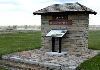
The Huff Archeological Site is a prehistoric Mandan village in North Dakota dated around 1450 AD. It was discovered in the early 1900s. The site has been designated a National Historic Landmark, and is one of the best preserved sites of the period.

The Sioux Quartzite is a Proterozoic quartzite that is found in the region around the intersection of Minnesota, South Dakota, and Iowa, and correlates with other rock units throughout the upper midwestern and southwestern United States. It was formed by braided river deposits, and its correlative units are thought to possibly define a large sedimentary wedge that once covered the passive margin on the then-southern side of the North American craton. In human history, it provided the catlinite, or pipestone, that was used by the Plains Indians to carve ceremonial pipes. With the arrival of Europeans, it was heavily quarried for building stone, and was used in many prominent structures in Sioux Falls, South Dakota and shipped to construction sites around the Midwest. Sioux Quartzite has been and continues to be quarried in Jasper, Minnesota at the Jasper Stone Company and Quarry, which itself was posted to the National Register of Historic Places on January 5, 1978. Jasper, Minnesota contains many turn-of-the-century quartzite buildings, including the school, churches and several other public and private structures, mostly abandoned.

Medicine Rocks State Park is a park owned by the state of Montana in the United States. It is located about 25 miles (40 km) west-southwest of Baker, Montana, and 11 miles (18 km) north of Ekalaka, Montana. The park is named for the "Medicine Rocks," a series of sandstone pillars similar to hoodoos some 60 to 80 feet high with eerie undulations, holes, and tunnels in them. The rocks contain numerous examples of Native American rock art and are considered a sacred place by Plains Indians. As a young rancher, future president Theodore Roosevelt said Medicine Rocks was "as fantastically beautiful a place as I have ever seen." The park is 330 acres (130 ha) in size, sits at 3,379 feet (1,030 m) in elevation, and is managed by the Montana Department of Fish, Wildlife and Parks. It was listed on the National Register of Historic Places in 2017 and designated as a certified International Dark Sky Sanctuary in 2020.
The High Butte Effigy and Village Site (32ME13) is an ancient Native American ceremonial site near the Garrison Dam and Riverdale, North Dakota. The site was listed on the National Register of Historic Places in 1978. It is located atop a butte and includes a "turf cut turtle effigy." Items recovered from the site include 14 points, 24 body sherds, five rim sherds, and a grooved paddle.

Deer Medicine Rocks is a sandstone formation located on the west bank of Rosebud Creek in the vicinity of Lame Deer, Montana, United States. The formation is significant for its association with the Great Sioux War of 1876-77, and its connection with Sitting Bull's visionary sun dance of early June 1876 which prophesied victory at the Battle of the Little Bighorn. At its nomination to National Historic Landmark status in 2011, it was described as the only site to offer "a wholly Native American historical interpretation of the Battle of the Little Big Horn."

Medicine Lodge State Archeological Site is a Wyoming state park that interprets the Medicine Lodge Creek Site, a prehistoric Native American archeological site near Hyattville, Wyoming. It is administered by the Wyoming Division of State Parks and Historic Sites. The site is at the base of a steep limestone outcropping near the point where the dry and running portions of Medicine Lodge Creek join. for a protected location with ready access to water. The site includes petroglyphs and pictographs on the rock face. Excavations starting in the 1970s have found twelve levels of habitation in 10.5 feet of stratum, ranging from historic times to 8300 years before the present. The site comprises a portion of the former Wickwire Ranch, which was purchased by the state in 1972 and became to Medicine Lodge Wildlife Habitat Management Area of 12,000 acres (4,900 ha). The archeological site was designated in 1973. The site is managed as a state park, with campgrounds and a visitor center. It was added to the National Register of Historic Places on July 5, 1973.
References
- 1 2 "National Register Information System". National Register of Historic Places . National Park Service. July 9, 2010.
- ↑ "Medicine Rock State Historic Site". State Historical Society of North Dakota.
| Topics | |
|---|---|
| Lists by state |
|
| Lists by insular areas | |
| Lists by associated state | |
| Other areas | |
| Related | |