Sonoyta, Sonora is a town in the northern Mexican state of Sonora. It stands on the U.S.-Mexico border, facing Lukeville, Arizona, in the United States. It is the municipal seat of the municipality of Plutarco Elías Calles.
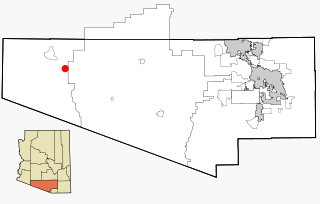
Why is a tiny unincorporated rural community in Pima County, Arizona, United States. It lies near the western border of the Tohono O'Odham Indian Reservation and due north of Organ Pipe Cactus National Monument in Southern Arizona. It is approximately 30 miles (48 km) north of the Mexican border where Lukeville, Arizona, and Sonoyta, Sonora, Mexico, border each other, and 10 miles (16 km) south of Ajo, Arizona.

North American area code 602 is a state of Arizona telephone area code that covers most of the city of Phoenix.

Pococí is the second canton in the province of Limón in Costa Rica. The canton covers an area of 2,403.49 km², making it the third largest of Costa Rica's 81 cantons. It has a population of 125,962 making it seventh-ranked. Its capital in the city of Guápiles, which houses many of the canton's services and businesses.

Golden Gate Barrio was a historic Mexican-American neighborhood in South Phoenix, Arizona. The neighborhood was razed due to eminent domain for the expansion of Phoenix Sky Harbor International Airport in the 1970s and 1980s through the West Approach Land Acquisition Project.

Towanda Township is located in McLean County, Illinois. As of the 2010 census, its population was 1,296 and it contained 555 housing units. It contains the entirety of the town of Towanda and a portion of the town of Normal.
The Rose Pauson House in Phoenix, Arizona, was designed by Frank Lloyd Wright in 1939 and built 1940–1942.
Little Bay East is a town in the Canadian province of Newfoundland and Labrador. The town had a population of 140 in the Canada 2006 Census.
Malana is a town and union council of Dera Ismail Khan District in Khyber Pakhtunkhwa province of Pakistan. It is located at 31°44'32N 70°51'50E and has an altitude of 135 metres . Many times this town is mistaken for another city, Malana in India, but these two places are distinct from each other. People born in Malana usually take a pilgrimage back home at least once.

The Episcopal Diocese of Arizona is the diocese of the Episcopal Church in the United States of America which has jurisdiction over most of Arizona. It is in Province VIII.
The John the Baptist Mountains are a small mountain range in western Pima County, Arizona, approximately 8.5 miles southwest of the town of Ajo, Arizona. The range is approximately three miles long and about one mile wide at its widest point. The highpoint of the range is 2,161 feet above sea level and is located at 32°15'24"N, 112°54'24"W. The bulk of the range lies on lands administered by the Bureau of Land Management, and a small portion extends westward into the Cabeza Prieta National Wildlife Refuge.

Kuusisaari (Finnish), Granö (Swedish) is an island and a neighborhood of Helsinki, Finland. It has the highest average income of all the Helsinki metropolitan area. Many foreign embassies are located in Kuusisaari.
The Biltmore is an upscale residential neighborhood & financial district in central North East Phoenix, Arizona. It is the city's most acclaimed neighborhood, largely due to its location, near the Arizona Biltmore Hotel. The local landmark was opened on 23 February 1929. The Resort is surrounded by two 18 hole championship golf courses built in 1928 and 1977 along with some of the most exclusive homes in the Valley of the Sun. The greater area is known as a financial district surrounded by upscale shopping, dining, and for its quality of life. The financial district is clustered with business and residential mid-rise tower buildings and gated neighborhoods along a line known as the "Camelback Corridor" which extends from Central Avenue, East on Camelback Road into Scottsdale.
Catoctin in Yavapai County, Arizona was a small gold mining camp. The camp was established around 1902 and received a post office on December 29 of the same year. It is located on upper Hassayampa River, sixteen miles southeast of Prescott, Arizona. Only a handful of mining buildings and homes were constructed and on average the town was home to about twenty people. The Catoctin and Climax mines were nearby. On July 15, 1920 the post office was closed.

The Gila Bend Mountains are a 35-mile (56 km) long mountain range of the north-central Sonoran Desert southwest of Phoenix, Arizona and in southwest Maricopa County.
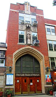
Our Lady Queen of Martyrs Church, located at 81 Arden Street at Dongan Place, between Broadway and Sherman Avenue in the Inwood neighborhood of Manhattan, New York City, is a Roman Catholic parish church in the Roman Catholic Archdiocese of New York. The parish was established in 1927 and a church was built in 1928 to designs by Gustave E. Steinback.

Mount Lemmon Air Force Station is a closed United States Air Force General Surveillance Radar station. It is located 17.2 miles (27.7 km) north-northeast of Tucson, Arizona. It was closed in 1969.
Miraflores is a small town in the Municipality of Los Cabos. Miraflores is located about 45 miles north of San Jose del Cabo, 2 km west of Highway 1, just to the east of the Sierra de la Laguna. Miraflores is 220 meters above sea level. As of 2010, the town had a population of 1,384.
Rainbow Valley is a rural neighborhood south of Buckeye, Arizona, United States. It is unincorporated, meaning it is not under the town of Buckeye but instead Maricopa County. It is a very spread out neighborhood with approximately only 34 people per square mile. To the east of Rainbow Valley is a community called "Estrella Mountain Ranch." The place has no hotels or stores you have to go to either Estrella Mountain Ranch in Goodyear or a few miles north to Buckeye. Rainbow Valley has lots of Mountains.
Grand Summit is an unincorporated community in Cowley County, Kansas, USA.