
Roxbury is a town in Litchfield County, Connecticut, United States. The population was 2,260 at the 2020 census. The town is located 65 miles (105 km) northeast of New York City, and is part of the Northwest Hills Planning Region.

Hudson Highlands State Park is a non-contiguous state park in the U.S. state of New York, located on the east side of the Hudson River. The park runs from Peekskill in Westchester County, through Putnam County, to Beacon in Dutchess County, in the eastern section of the Hudson Highlands.

Blaenavon Industrial Landscape, in and around Blaenavon, Torfaen, Wales, was inscribed a World Heritage Site by UNESCO in 2000. The Blaenavon Ironworks, now a museum, was a major centre of iron production using locally mined or quarried iron ore, coal and limestone. Raw materials and products were transported via horse-drawn tramroads, canals and steam railways. The Landscape includes protected or listed monuments of the industrial processes, transport infrastructure, workers' housing and other aspects of early industrialisation in South Wales.

Finedon is a town and civil parish in North Northamptonshire, England, with a population at the 2021 census of 4,552. In 1086 when the Domesday Book was completed, Finedon was a large royal manor, previously held by Queen Edith, wife of Edward the Confessor.

Greenwood Furnace State Park is a 423-acre (171 ha) Pennsylvania state park in Jackson Township, Huntingdon County, Pennsylvania in the United States. The park is near the historic iron making center of Greenwood Furnace. The park includes the ghost town of Greenwood that grew up around the ironworks, old roads and charcoal hearths. Greenwood Furnace State Park is adjacent to Rothrock State Forest and on the western edge of an area of Central Pennsylvania known as the Seven Mountains. The park is on Pennsylvania Route 305, 20 miles (32 km) south of State College.

Ruffner Mountain Nature Preserve is a 1,038 acres (4.20 km2) nature preserve located in the eastern portion of Jefferson County, Alabama, in the City of Birmingham's historic South East Lake neighborhood. The preserve includes a visitor center containing native Alabama animals including raptors, snakes, turtles, and owls. The Ruffner Mountain area was home to iron ore mines and stone quarries, supplying the area's steel mills.

The Tannehill Ironworks is the central feature of Tannehill Ironworks Historical State Park near the unincorporated town of McCalla in Tuscaloosa County, Alabama. Listed on the National Register of Historic Places as Tannehill Furnace, it was a major supplier of iron for Confederate ordnance. Remains of the old furnaces are located 12 miles (19 km) south of Bessemer off Interstate 59/Interstate 20 near the southern end of the Appalachian Mountains. The 2,063-acre (835 ha) park includes: the John Wesley Hall Grist Mill; the May Plantation Cotton Gin House; and the Iron & Steel Museum of Alabama.

Pendarvis is a historic site located in Mineral Point, Iowa County, Wisconsin, United States. The site, which is listed on the National Register of Historic Places, is made up of several 19th century stone and timber cabins built by Cornish immigrants who came to Mineral Point to mine lead and zinc. Today the site is owned by the Wisconsin Historical Society and serves as a museum of Wisconsin's early lead mining history. Programs at the site also interpret the groundbreaking preservation work by Robert Neal and Edgar Hellum, begun during the Great Depression.
Pine Grove Furnace State Park is a protected Pennsylvania area that includes Laurel and Fuller Lakes in Cooke Township of Cumberland County. The Park accommodates various outdoor recreation activities, protects the remains of the Pine Grove Iron Works (1764), and was the site of Laurel Forge (1830), Pine Grove Park (1880s), and a brick plant (1892). The Park is 8 miles (13 km) from exit 37 of Interstate 81 on Pennsylvania Route 233.

Morwellham Quay is an historic river port in Devon, England that developed to support the local mines. The port had its peak in the Victorian era and is now run as a tourist attraction and museum. It is the terminus of the Tavistock Canal, and has its own copper mine.

The Gogebic Range is an elongated area of iron ore deposits located within a range of hills in northern Michigan and Wisconsin just south of Lake Superior. It extends from Lake Namakagon in Wisconsin eastward to Lake Gogebic in Michigan, or almost 80 miles. Though long, it is only about a half mile wide and forms a crescent concave to the southeast. The Gogebic Range includes the communities of Ironwood in Michigan, plus Mellen and Hurley in Wisconsin.

The Sterling Hill Mine, now known as the Sterling Hill Mining Museum, is a former zinc mine in Ogdensburg, Sussex County, New Jersey, United States. It was the last working underground mine in New Jersey. It closed in 1986, and became a museum in 1989. Along with the nearby Franklin Mine, it is known for its variety of minerals, especially the fluorescent varieties. It was added to the National Register of Historic Places in 1991.

The Jackson Mine is an open pit iron mine in Negaunee, Michigan, extracting resources from the Marquette Iron Range. The first iron mine in the Lake Superior region, Jackson Mine was designated as a Michigan State Historic Site in 1956 and listed on the National Register of Historic Places in 1971. The Lake Superior Mining Institute said, the mine "is attractive in the iron ore region of Michigan and the entire Lake Superior region, because of the fact it was here that the first discovery of iron ore was made, here the first mining was done, and from its ore the first iron was manufactured." Multiple other mines soon followed the Jackson's lead, establishing the foundation of the economy of the entire region. The mine is located northwest of intersection of Business M-28 and Cornish Town Road.

The Schoolcraft Furnace site is an abandoned iron furnace site located just east of Munising, Michigan, within the Pictured Rocks National Lakeshore near the Munising Falls Visitor Center. It was listed on the National Register of Historic Places in 1977. It is also known as the Munising Furnace.
The Pine Grove Iron Works was a smelting facility in southcentral Pennsylvania during the Industrial Revolution. The works is notable for remaining structures that are historical visitor attractions of Pine Grove Furnace State Park, including the furnace stack of the Pine Grove Furnace. The site was listed on the National Register of Historic Places on April 13, 1977 for its significance in architecture and industry. It includes seven contributing buildings, two structures, fourteen sites, and two objects.
Iron Hill is a prominent geographical feature in the vicinity of Newark, Delaware, in the United States. With a topographic prominence of 200 feet (61 m), it is the most prominent hill in Delaware. However, its peak elevation of 328 feet (100 m) means that it is not the state's highest point, which is located in the Piedmont plateau region near Centreville where a peak elevation of 448 feet (137 m) is attained at Ebright Azimuth. The hill is named for its iron deposits, which were mined over a 200-year period during the 18th and 19th centuries. It is part of a New Castle County park known as Iron Hill Park.

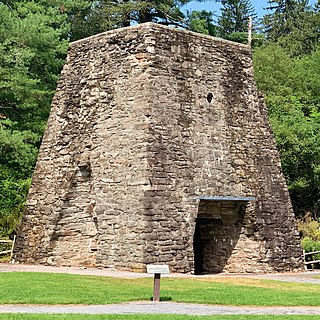
The Southfield Furnace Ruin in Southfields, New York, was a longtime smelting site for iron ore mined from nearby veins in what is now Sterling Forest State Park. It is located on the north side of Orange County Route 19, 0.7 miles northwest of the junction with New York State Route 17.
A group of mines on Ecton Hill, Staffordshire, are unusual for the Peak District in producing predominantly copper rather than lead and zinc. The most important, Deep Ecton mine, has been mined since the Bronze Age, and in the 18th century was a major producer of copper, and the deepest mine in Britain. Mining below river level ceased in the 1850s, and all production stopped in the 1890s. The mine is now a significant educational resource, managed by the Ecton Mine Educational Trust, and with teaching provided by the Ecton Hill Field Studies Association.

The Brendon Hills are a range of hills in western Somerset, England. The hills merge level into the eastern side of Exmoor and are included within the Exmoor National Park. Iron ore and other minerals have been extracted for industrial purposes, primarily by the Brendon Hills Iron Ore Company in the later half of the 19th century.

The Cadia Mine railway line is a closed and dismantled railway line in New South Wales, Australia. The 18.5 km long branch line started where it branched from the Main Western Railway line at Spring Hill and ended at Cadia. Its main role was to carry iron ore from the quarry at Cadia and for much of its life was privately operated.


