Minot Air Force Station

Last updated

Minot Air Force Station
Air Defense Command.svg
Part of Air Defense Command (ADC)
Gasman Township, Ward County, south of Minot, North Dakota
USA North Dakota location map.svg
Red pog.svg
Minot AFS
Location of Minot AFS, North Dakota
Coordinates 48°00′13″N101°17′40″W / 48.00361°N 101.29444°W / 48.00361; -101.29444 (Minot AFS P-28)
TypeAir Force station
CodeQJVM (ILC)
Site information
Ownercivilian
Controlled byFlag of the United States Air Force.svg  United States Air Force
Site history
In useMay 1951–September 1979, 1984–1997
Garrison information
Garrison 786th Radar Squadron

Minot Air Force Station (ADC ID: P-28 NORAD ID: Z-28) [Permanent Installation Number (PIN): 1445; Installation Location Code (ILC): QJVM]) is a closed United States Air Force General Surveillance Radar station. It is located 16.2 miles (26.1 km) south of Minot, North Dakota; on the west side of US Highway 83. It was closed in 1979. A portion of the property was reopened in 1984 as the Minot Communications Site and served until 1997.

Contents

Minot Air Force Station was the first major Air Force installation in North Dakota, even predating the two "large" bases, Minot Air Force Base and Grand Forks Air Force Base.

History

Minot Air Force Station was part of the last batch of twenty-three radar stations constructed as part of the Air Defense Command permanent network. It was activated on 20 May 1951 at Max, ND, and declared completely operational in 1952.

The 786th Aircraft Control and Warning Squadron began operations with AN/FPS-3 and AN/FPS-5 radars in April 1952, and initially the station functioned as a Ground-Control Intercept (GCI) and warning station. As a GCI station, the squadron's role was to guide interceptor aircraft toward unidentified intruders picked up on the unit's radar scopes.

It was named Minot Air Force Station on 1 December 1953. During 1957 an AN/GPS-3 search radar saw brief use. In 1958 the original radars were replaced by AN/FPS-20 search and AN/FPS-6 height-finder sets. A second height-finder set, AN/FPS-6B, was installed during the following year.

During 1961 Minot AFS joined the Semi Automatic Ground Environment (SAGE) system, initially feeding data to DC-20 at Malmstrom AFB, Montana. After joining, the squadron was redesignated as the 786th Radar Squadron (SAGE) on 15 July 1961. The radar squadron provided information 24/7 the SAGE Direction Center where it was analyzed to determine range, direction altitude speed and whether or not aircraft were friendly or hostile.

By the end of 1961 the search set had been upgraded and redesignated as an AN/FPS-66. On 31 July 1963, the site was redesignated as NORAD ID Z-28.

An AN/FPS-26A height-finder radar was installed in 1964, and the AN/FPS-6 was retired. The AN/FPS-6B was upgraded to an AN/FPS-90 also that year. In 1964 the site received an AN/FPS-27 search radar which became fully operational in early 1965. The AN/FPS-66 was removed later in 1965. In 1968 the AN/FPS-90 was retired.

In addition to the main facility, Minot operated three unmanned AN/FPS-14 (P-28A) and AN/FPS-18 (P-28B/C) Gap Filler sites:

The Alexander site was reassigned to Minot after Dickinson AFS (Z-177) closed in 1965. The site is now home to the Watford City Joint Surveillance System (JSS) (ARSR-4) LRR site (Z-300/J-76).

Over the years, the equipment at the station was upgraded or modified to improve the efficiency and accuracy of the information gathered by the radars. In early 1979 the Air Force announced that the station would be closing due to what was called "redundancies with more strategically located radars".[ This quote needs a citation ] On 29 September 1979 the 786th Radar Squadron was inactivated and the station was closed.

In 1984, a portion of the station was reopened by the USAF as the Minot Communication Site. It was closed again in 1997 and struck from the USAF property register and liquidated c.. 1998. Minot AFS has been sold to civilian interests, and has been reused as a housing subdivision colloquially known as the Radar Base.

Buildings and facilities

Buildings on the station include: [1]

Air Force units and assignments

Emblem of the 786th Radar Squadron On a medium blue shield edged black, a black silhouetted map of the United States, bordered white, surmounted in the chief area of the shield by a black silhouetted radome edged white; an arrow piercing the radome, a radar scope on lower part of radome and two silhouetted aircraft in northwest and southeast corners respectively of the map, all white, details black. The emblem is symbolic of the Aircraft Control and Warning Mission in that electronic detection is indicated by the lightning bolt through the radome; surveillance and control is represented by the radar scope and aircraft and the map of the United States represents the Squadron's constant vigilance in safe-guarding our nation. emblem approved for use: 16 November 1956. 786th Radar Squadron - Emblem.png
Emblem of the 786th Radar Squadron On a medium blue shield edged black, a black silhouetted map of the United States, bordered white, surmounted in the chief area of the shield by a black silhouetted radome edged white; an arrow piercing the radome, a radar scope on lower part of radome and two silhouetted aircraft in northwest and southeast corners respectively of the map, all white, details black.The emblem is symbolic of the Aircraft Control and Warning Mission in that electronic detection is indicated by the lightning bolt through the radome; surveillance and control is represented by the radar scope and aircraft and the map of the United States represents the Squadron's constant vigilance in safe-guarding our nation. emblem approved for use: 16 November 1956.

Units

Activated on 20 May 1951
Redesignated as 786th Radar Squadron (SAGE) on 15 July 1961
Redesignated as 786th Radar Squadron on 1 February 1974
Inactivated: 29 September 1979

Assignments

Commanders

See also

Related Research Articles

<span class="mw-page-title-main">Fortuna Air Force Station</span> North Dakota, an abandoned Air Force Long Range radar site

Fortuna Air Force Station is a closed United States Air Force General Surveillance Radar station. It is located 4.2 miles (6.8 km) west of Fortuna, North Dakota. It was closed in 1979 as a radar station, remaining as a Long-Range Radar (LRR) facility until 1984.

<span class="mw-page-title-main">Finley Air Force Station</span> Former US Air Force radar station

Finley Air Force Station is a closed United States Air Force General Surveillance Radar station. It is located 1.5 miles (2.4 km) west-northwest of Finley, North Dakota. It was closed in 1979 by the Air Force, and turned over to the Federal Aviation Administration (FAA).

Dickinson Air Force Station is a closed United States Air Force General Surveillance Radar station. It is located 3.8 miles (6.1 km) northeast of Dickinson, North Dakota. It was closed in 1965.

<span class="mw-page-title-main">Antigo Air Force Station</span> Closed United States Air Force General Surveillance Radar station

Antigo Air Force Station is a closed United States Air Force General Surveillance Radar station. It is located 7.5 miles (12.1 km) south-southwest of Antigo, Wisconsin. It was closed in 1977 and is currently classified as a high risk toxic waste site involving groundwater, sediment, soil and surface water.

<span class="mw-page-title-main">Calumet Air Force Station</span> Abandoned Aircraft Control and Warning System located near Calumet, Michigan

Calumet Air Force Station is a closed United States Air Force General Surveillance Radar station. It is located 5.2 miles (8.4 km) east-northeast of Phoenix, Michigan. It was closed in 1988 by the Air Force, and turned over to the Federal Aviation Administration (FAA).

<span class="mw-page-title-main">Cut Bank Air Force Station</span> US Air Force radar station

Cut Bank Air Force Station is a closed United States Air Force General Surveillance Radar station. It is located 30.4 miles (48.9 km) northwest of Cut Bank, Montana. It was closed in 1965.

<span class="mw-page-title-main">Caswell Air Force Station</span> Former Air Force radar station

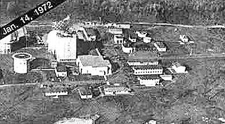
Caswell Air Force Station is a closed United States Air Force General Surveillance Radar station. It is located 4.3 miles (6.9 km) north of Limestone, Maine. It was closed in 1980.

<span class="mw-page-title-main">Belleville Air Force Station</span> Closed United States Air Force General Surveillance Radar station

Belleville Air Force Station is a closed United States Air Force General Surveillance Radar station. It is located 2 miles (3.2 km) southeast of Belleville, Illinois. It was closed in 1968.

<span class="mw-page-title-main">Kirksville Air Force Station</span> Former US Air Force radar station in Missouri

Kirksville Air Force Station is a closed United States Air Force General Surveillance Radar station. It is located 7.1 miles (11.4 km) north of Kirksville, Missouri. It was closed by the Air Force in 1968. Today the radar site is used by the Federal Aviation Administration (FAA) as a Joint Surveillance System (JSS) site.

<span class="mw-page-title-main">Bellefontaine Air Force Station</span> Former US Air Force radar station in Ohio

Bellefontaine Air Force Station is a closed United States Air Force General Surveillance Radar station. It is located 2.3 miles (3.7 km) east-northeast of Bellefontaine, Ohio. It was closed in 1969.

Omaha Air Force Station is a closed United States Air Force General Surveillance Radar station. It is located 7.5 miles (12.1 km) north of Omaha, Nebraska. It was closed in 1968.

<span class="mw-page-title-main">Finland Air Force Station</span> Radar station in Minnesota, US 1950–1980

Finland Air Force Station is a closed United States Air Force General Surveillance Radar station. It is located 2.8 miles (4.5 km) north of Finland, Minnesota. It was closed in 1980.

Wadena Air Force Station is a closed United States Air Force General Surveillance Radar station. It is located 7 miles (11 km) north-northeast of Wadena, Minnesota. It was closed in 1970.

<span class="mw-page-title-main">Opheim Air Force Station</span> Closed United States Air Force General Surveillance Radar station

Opheim Air Force Station is a closed United States Air Force General Surveillance Radar station. It is located 3.3 miles (5.3 km) west of Opheim, Montana. It was closed in 1979.

<span class="mw-page-title-main">Havre Air Force Station</span> Surveillance radar station during the Cold War

Havre Air Force Station is a Formerly Used Defense Site that was used as a Cold War general surveillance radar station. In addition to radar facilities and a NORAD Control Center the site had support services: NCO club, bowling alley, hobby shops, library, movie theater, barber shop, exchange, commissary, grade school, and housing for officers and senior NCOs.

<span class="mw-page-title-main">Mount Laguna Air Force Station</span> Radar station in California, US 1952–1981

Mount Laguna Air Force Station is a closed United States Air Force General Surveillance Radar station. It is located 24.3 miles (39.1 km) north-northeast of Tecate, California. It was closed in 1981 by the Air Force, and turned over to the Federal Aviation Administration (FAA).

North Bend Air Force Station is a closed United States Air Force General Surveillance Radar station. It is located 3.9 miles (6.3 km) north-northeast of Hauser, Oregon. It was closed in 1980.

Othello Air Force Station is a closed United States Air Force General Surveillance Radar station. It is located 7.2 miles (11.6 km) south of Othello, Washington. It was the home station of the 637th Aircraft Control and Warning Squadron and the 637th Air Defense Group, closing in 1975.

<span class="mw-page-title-main">Blaine Air Force Station</span> Closed United States Air Force General Surveillance Radar station

Blaine Air Force Station is a closed United States Air Force General Surveillance Radar station. It is located 5.5 miles (8.9 km) south of Blaine, Washington. It was closed in 1979.

<span class="mw-page-title-main">Hutchinson Air Force Station</span> Closed United States Air Force station

Hutchinson Air Force Station is a closed United States Air Force station. It is located 2 miles (3.2 km) west-southwest of Yoder, Kansas. It was closed for all military use in 1968. It was operated alongside Hutchinson Air National Guard Base when it was operational.

References

PD-icon.svg This article incorporates public domain material from the Air Force Historical Research Agency

  1. "Squadron Activities - Armed Forces Day" (Document). Minot Air Force Station: 786th Aircraft Control and Warning Squadron. 17 May 1958.