Winston-Salem Air Force Station

Last updated

Winston-Salem Air Force Station
Air Defense Command.svg
Part of Air Defense Command (ADC)
USA North Carolina location map.svg
Red pog.svg
Winston-Salem AFS
Location of Winston-Salem AFS, North Carolina
Coordinates 36°02′30″N080°08′18″W / 36.04167°N 80.13833°W / 36.04167; -80.13833 (Winston-Salem AFS M-130)
TypeAir Force Station
Site information
Controlled byFlag of the United States Air Force.svg  United States Air Force
Site history
Built1956
In use1956-1970
Garrison information
Garrison810th Aircraft Control and Warning (later Radar) Squadron
Emblem of the 810th Radar Squadron 810th Radar Squadron - Emblem.png
Emblem of the 810th Radar Squadron

Winston-Salem Air Force Station (ADC ID: M-130 NORAD ID: Z-130) is a closed United States Air Force General Surveillance Radar station that was active from 1956 to 1970. It is located 1 mile (1.6 km) southeast of Winston-Salem, North Carolina.

Contents

History

Winston-Salem AFS was established in 1954 by Air Defense Command as one of a planned deployment of forty-four Mobile radar stations to support the permanent ADC Radar network in the United States sited around the perimeter of the country. This deployment was projected to be operational by mid-1952. Funding, constant site changes, construction, and equipment delivery delayed deployment.

This site became operational on 1 December 1956 when the 810th Aircraft Control and Warning Squadron was assigned to Winston-Salem AFS with AN/MPS-11 and AN/FPS-6A radars, and initially the station functioned as a Ground-Control Intercept (GCI) and warning station. As a GCI station, the squadron's role was to guide interceptor aircraft toward unidentified intruders picked up on the unit's radar scopes. The AN/MPS-11 set was replaced by an AN/FPS-8 radar that saw service between 1960 and 1962. In 1962 the 810th began operating AN/FPS-24 search and AN/FPS-26 height-finder radars along with the previously installed AN/FPS-6 set.

During 1962 Winston-Salem AFS joined the Semi Automatic Ground Environment (SAGE) system, initially feeding data to DC-04 at Fort Lee AFS, Virginia. After joining, the squadron was redesignated as the 810th Radar Squadron (SAGE) on 1 March 1962. The radar squadron provided information 24/7 the SAGE Direction Center where it was analyzed to determine range, direction altitude speed and whether or not aircraft were friendly or hostile. On 31 July 1963, the site was redesignated as NORAD ID Z-130. The AN/FPS-6A was retired in 1968.

In addition to the main facility, Winston-Salem AFS operated an AN/FPS-18 unmanned Gap Filler site:

The 810th was inactivated on 31 July 1970 as part of a general reduction of Aerospace Defense Command air defense units.

Today some former USAF buildings now used as part of a light industrial complex. The large AN/FPS-24 tower still stands, as well as most of the support buildings and barracks. The housing area is in private hands. Some of the buildings are used by ARCA Addiction Recovery Care Association and Google offers an excellent view at https://www.google.com/maps?q=1931+Union+Cross+Road+Winston+Salem,+NC+27107&hl=en&ll=36.044363,-80.136168&spn=0.002622,0.004128&sll=35.225278,-80.635278&sspn=0.006591,0.011576&t=h&hnear=1931+Union+Cross+Rd,+Winston-Salem,+Forsyth,+North+Carolina+27107&z=19 where the radar building can be seen clearly without the radar that was once on top of the structure. During the late 1960s the base was visited by both Club and Boy Scout troops as part of a Merit Badge exercise.

Air Force units and assignments

Units

Activated at Dobbins AFB (M-111), GA on 20 June 1953 (not equipped or manned)
Moved to Andrews AFB (SM-171), MD on 1 July 1956 (not equipped or manned)
Moved to Winston-Salem AFS on 1 December 1956
Redesignated as 810th Radar Squadron (SAGE) on 1 March 1962
Inactivated on 31 July 1970

Assignments

See also

Related Research Articles

Claysburg Air Force Station is a closed United States Air Force General Surveillance Radar station. It is located 6 miles (9.7 km) west of Claysburg, Pennsylvania. It was closed in 1961 due to budget constraints. The unit was eventually moved to Gibbsboro Air Force Station (RP-63), New Jersey.

<span class="mw-page-title-main">Antigo Air Force Station</span> Closed United States Air Force General Surveillance Radar station

Antigo Air Force Station is a closed United States Air Force General Surveillance Radar station. It is located 7.5 miles (12.1 km) south-southwest of Antigo, Wisconsin. It was closed in 1977 and is currently classified as a high risk toxic waste site involving groundwater, sediment, soil and surface water.

Bedford Air Force Station is a closed United States Air Force General Surveillance Radar station. It is located 12.7 miles (20.4 km) north of Bedford, Virginia. It was closed in 1975.

Manassas Air Force Station is a closed United States Air Force General Surveillance Radar station. It is located 7.4 miles (11.9 km) west of Dale City, Virginia. It was closed in 1965.

North Charleston Air Force Station is a closed United States Air Force General Surveillance Radar station. It is located in the City of North Charleston, South Carolina. It was closed in 1980.

Roanoke Rapids Air Force Station was a United States Air Force General Surveillance Radar station. It is 6.1 miles (9.8 km) southwest of Gaston, North Carolina, near the closed Halifax County Airport. It was closed in 1978.

<span class="mw-page-title-main">Brunswick Air Force Station</span> Closed United States Air Force station in Brunswick, Maine

Brunswick Air Force Station is a closed United States Air Force General Surveillance Radar station. It is located 2.5 miles (4.0 km) east-southeast of Brunswick, Maine. It was closed in 1965.

<span class="mw-page-title-main">Caswell Air Force Station</span> Former Air Force radar station

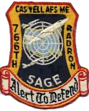
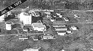
Caswell Air Force Station is a closed United States Air Force General Surveillance Radar station. It is located 4.3 miles (6.9 km) north of Limestone, Maine. It was closed in 1980.

Saratoga Springs Air Force Station is a closed United States Air Force General Surveillance Radar station. It is located 7.2 miles (11.6 km) southeast of Saratoga Springs, New York. It was closed by the Air Force in 1977.

Snow Mountain Air Force Station is a closed United States Air Force General Surveillance Radar station. It is located 1.9 miles (3.1 km) west-southwest of Godman Army Airfield, Kentucky. It was closed in 1968.

<span class="mw-page-title-main">Belleville Air Force Station</span> Closed United States Air Force General Surveillance Radar station

Belleville Air Force Station is a closed United States Air Force General Surveillance Radar station. It is located 2 miles (3.2 km) southeast of Belleville, Illinois. It was closed in 1968.

<span class="mw-page-title-main">Custer Air Force Station</span> Radar station in Michigan, US 1952–1965

Custer Air Force Station is a closed United States Air Force General Surveillance Radar and Direction Center station. It is located 5.3 miles (8.5 km) west-northwest of Battle Creek, Michigan. It was closed in 1969.

<span class="mw-page-title-main">Bellefontaine Air Force Station</span> Former US Air Force radar station in Ohio

Bellefontaine Air Force Station is a closed United States Air Force General Surveillance Radar station. It is located 2.3 miles (3.7 km) east-northeast of Bellefontaine, Ohio. It was closed in 1969.

Omaha Air Force Station is a closed United States Air Force General Surveillance Radar station. It is located 7.5 miles (12.1 km) north of Omaha, Nebraska. It was closed in 1968.

<span class="mw-page-title-main">Grand Rapids Air Force Station</span> Closed US military installation

Grand Rapids Air Force Station is a closed United States Air Force General Surveillance Radar station. It is located 0.7 miles (1.1 km) east-northeast of Grand Rapids, Minnesota. It was closed in 1963.

<span class="mw-page-title-main">Gettysburg Air Force Station</span> Radar station in South Dakota, US 1956–1965

Gettysburg Air Force Station is a closed United States Air Force General Surveillance Radar station. It is located 2.6 miles (4.2 km) north of Gettysburg, South Dakota. It was closed in 1968.

Cambria Air Force Station is a closed United States Air Force General Surveillance Radar station. It is 3 miles (4.8 km) south-southeast of Cambria, California. It was closed in 1980.

Mica Peak Air Force Station is a closed United States Air Force General Surveillance Radar station. It is located atop Mica Peak, 6.3 miles (10.1 km) east-northeast of Mica, Washington. It was closed in 1975 by the Air Force, and turned over to the Federal Aviation Administration (FAA).

<span class="mw-page-title-main">Kalispell Air Force Station</span>

Kalispell Air Force Station is a closed United States Air Force General Surveillance Radar station. It is located 13.3 miles (21.4 km) south of Kalispell, Montana near the community of Lakeside.

<span class="mw-page-title-main">Hutchinson Air Force Station</span> Closed United States Air Force station

Hutchinson Air Force Station is a closed United States Air Force station. It is located 2 miles (3.2 km) west-southwest of Yoder, Kansas. It was closed for all military use in 1968. It was operated alongside Hutchinson Air National Guard Base when it was operational.

References

PD-icon.svg This article incorporates public domain material from the Air Force Historical Research Agency