Monadnock Mountain (Vermont)

Last updated
Monadnock Mountain
Highest point
Elevation 3,148 ft (960 m) [1]
Prominence 1,528 ft (466 m)
Isolation 5.91 mi (9.51 km)
Coordinates 44°53′51″N71°32′40″W / 44.89750°N 71.54444°W / 44.89750; -71.54444
Geography
Location Essex County, Vermont, U.S.
Topo map USGS Monadnock Mountain

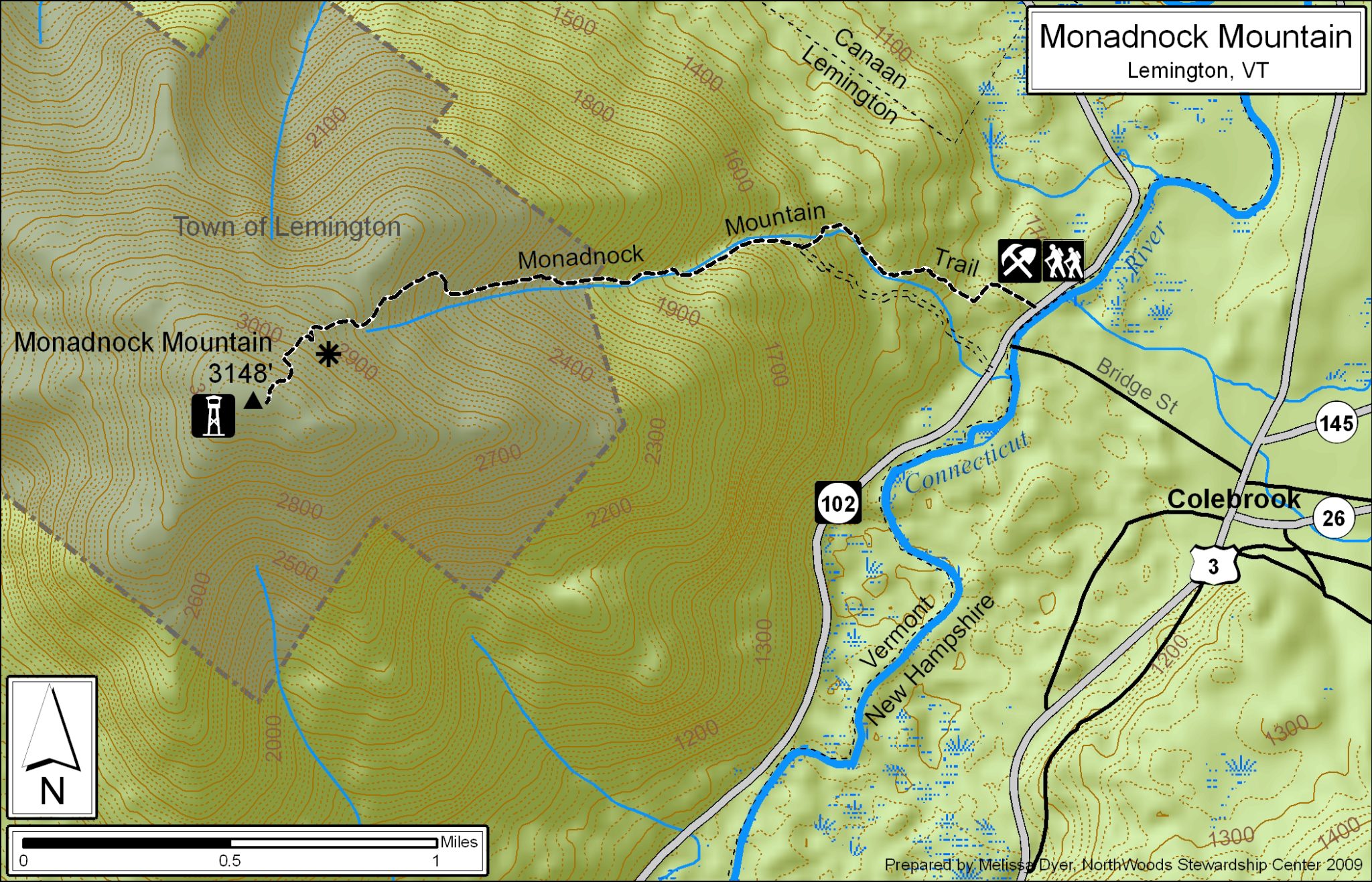
Monadnock Mountain, also called Mount Monadnock, is an inselberg located in the town of Lemington in the Northeast Kingdom region of the U.S. state of Vermont. The mountain overlooks the Connecticut River and the town of Colebrook, New Hampshire to the east. At its highest point, the mountain is 3,148 ft (960 m) high. [2] At the summit, an old fire tower offers excellent views of both Vermont and New Hampshire. [3] On a clear day, the view extends as far east as Maine and as far north as Quebec. [4]

Contents

The Monadnock Mountain Trail ascends the eastern slope of the mountain. The trailhead is adjacent to Vermont Route 102, 7.7 mi (12.4 km) south of Canaan and 13 mi (21 km) north of Bloomfield. The hike from the trailhead to the summit is 2.5 mi (4.0 km) with a gain in elevation of 2,130 ft (650 m). [5]

Norton Mine

The Norton Mine, (located in Lemington, VT, not Norton, VT) is an abandoned gold mine located near the base of the mountain. It is accessible from the trail along Route 102, turning southwest at 1400' elevation. [6]

The entrance is currently blocked by boulders.

Climate

Mount Monadnock has a humid continental climate (Köppen Dfb) with subarctic climate (Köppen Dfc) characteristics. There is no weather station, but this climate table contains interpolated data.

Climate data for Monadnock Mountain (VT) 44.8997 N, 71.5499 W, Elevation: 2,871 ft (875 m) (1991–2020 normals)
MonthJanFebMarAprMayJunJulAugSepOctNovDecYear
Mean daily maximum °F (°C)19.7
(−6.8)
22.0
(−5.6)
30.5
(−0.8)
44.9
(7.2)
58.4
(14.7)
67.1
(19.5)
71.5
(21.9)
70.2
(21.2)
63.6
(17.6)
50.3
(10.2)
36.2
(2.3)
26.0
(−3.3)
46.7
(8.2)
Daily mean °F (°C)10.3
(−12.1)
12.1
(−11.1)
20.8
(−6.2)
35.2
(1.8)
47.4
(8.6)
56.5
(13.6)
61.0
(16.1)
59.6
(15.3)
52.9
(11.6)
41.1
(5.1)
29.0
(−1.7)
18.0
(−7.8)
37.0
(2.8)
Mean daily minimum °F (°C)0.9
(−17.3)
2.3
(−16.5)
11.1
(−11.6)
25.5
(−3.6)
36.5
(2.5)
46.0
(7.8)
50.6
(10.3)
49.0
(9.4)
42.1
(5.6)
31.8
(−0.1)
21.7
(−5.7)
10.0
(−12.2)
27.3
(−2.6)
Average precipitation inches (mm)4.02
(102)
3.24
(82)
4.04
(103)
4.09
(104)
4.64
(118)
5.69
(145)
5.16
(131)
5.46
(139)
4.67
(119)
5.01
(127)
4.12
(105)
4.41
(112)
54.55
(1,387)
Source: PRISM Climate Group [7]

See also

Related Research Articles

<span class="mw-page-title-main">Columbia, New Hampshire</span> Town in New Hampshire, United States

Columbia is a town in Coös County, New Hampshire, United States. The population was 659 at the 2020 census, down from 757 at the 2010 census. It is part of the Berlin, NH-VT micropolitan statistical area.

<span class="mw-page-title-main">Mount Monadnock</span> Mountain in New Hampshire, USA

Mount Monadnock, or Grand Monadnock, is a mountain in the towns of Jaffrey and Dublin, New Hampshire. It is the most prominent mountain peak in southern New Hampshire and is the highest point in Cheshire County. It lies 38 miles (61 km) southwest of Concord and 62 miles (100 km) northwest of Boston. At 3,165 feet (965 m), Mount Monadnock is nearly 1,000 feet (305 m) higher than any other mountain peak within 30 miles (48 km) and rises 2,000 feet (610 m) above the surrounding landscape. Monadnock's bare, isolated, and rocky summit provides expansive views. It is known for being featured in the writings of Ralph Waldo Emerson and Henry David Thoreau.

<span class="mw-page-title-main">San Gorgonio Mountain</span> Highest peak of the Transverse Ranges of California, United States

San Gorgonio Mountain, also known locally as Mount San Gorgonio, or Old Greyback, is the highest peak in Southern California and the Transverse Ranges at 11,503 feet (3,506 m).

<span class="mw-page-title-main">Mount Adams (New Hampshire)</span> Mountain in New Hampshire, United States

Mount Adams, elevation 5,793 feet (1,766 m) above sea level, is a mountain in New Hampshire, the second highest peak in the Northeast United States after its nearby neighbor, Mount Washington. Located in the northern Presidential Range, Mount Adams was named after John Adams, the second President of the United States. It was given this name on July 31, 1820. To the northeast is Mount Madison and to the southwest is Mount Jefferson. From the summit, Mount Washington can be seen directly to the south.

<span class="mw-page-title-main">Mount Eisenhower</span> Mountain in the American state of New Hampshire

Mount Eisenhower, formerly Mount Pleasant, is a mountain in the Presidential Range in the White Mountains of New Hampshire approximately 4,757 feet (1,450 m) high. Named after President Dwight D. Eisenhower, its summit offers a 360° view. It is inaccessible by road.

<span class="mw-page-title-main">Humphreys Peak</span> Highest mountain in Arizona

Humphreys Peak is the highest natural point and the second most prominent peak after Mount Graham in the U.S. state of Arizona, with an elevation of 12,633 feet (3,851 m) and is located within the Kachina Peaks Wilderness in the Coconino National Forest, about 11 miles (17.7 km) north of Flagstaff, Arizona. Humphreys Peak is the highest of a group of dormant volcanic peaks known as the San Francisco Peaks.

<span class="mw-page-title-main">Mount Madison</span> Mountain in New Hampshire, United States

Mount Madison is a 5,367-foot (1,636 m) mountain in the Presidential Range of New Hampshire in the United States. It is named after the fourth U.S. President, James Madison.

<span class="mw-page-title-main">Mount Nebo (Utah)</span> Mountain in Utah, United States

Mount Nebo is the southernmost and highest mountain in the Wasatch Range of Utah, in the United States, and the centerpiece of the Mount Nebo Wilderness, inside the Uinta National Forest. It is named after the biblical Mount Nebo, overlooking Israel from the east of the Jordan River, which is said to be the place of Moses' death.

<span class="mw-page-title-main">Camel's Hump</span> Mountain in Vermont, US

Camel's Hump is a mountain in the Green Mountains in the U.S. state of Vermont. The north slope of the mountain borders the Winooski River, which has carved through the Green Mountains over eons. At 4,083 ft (1,244 m), it is tied with Mount Ellen for the third-highest mountain in Vermont. Surmounted by 10 acres (4 ha) of alpine tundra, the mountain is the most significant feature in Camel's Hump State Park. Because of its distinctive profile, it is perhaps the state's most recognized mountain, featured on the state quarter.

<span class="mw-page-title-main">Dix Mountain</span> Mountain in New York, United States

Dix Mountain is a mountain in the Dix Range of the Adirondacks in the U.S. state of New York. With an elevation of 4,857 feet (1,480 m), it is the sixth highest peak in New York and one of the 46 Adirondack High Peaks. It is located roughly on the boundary between the towns of North Hudson and Keene in Essex County, and in the High Peaks Wilderness Area of Adirondack Park. The crest of the peak consists of a very narrow ridge, which continues to the southeast and rises to a subsidiary peak named Beckhorn, then continues south to other peaks of the Dix Range. The summit is also in an alpine zone above the treeline. The ridge offers unobstructed views of Elk Lake to the southwest, the Great Range to the northwest, and Lake Champlain and the Green Mountains to the east.

<span class="mw-page-title-main">Carter Dome</span> Mountain in New Hampshire, United States

Carter Dome, or simply The Dome, is a mountain located in Coos County, New Hampshire. The mountain is part of the Carter-Moriah Range of the White Mountains, which runs along the northern east side of Pinkham Notch. Carter Dome is flanked to the northeast by Mount Hight and to the southwest by Wildcat Mountain.

<span class="mw-page-title-main">Mount Abraham (Vermont)</span> Mountain in Vermont, U.S.

Mount Abraham is a mountain in the Green Mountains in the U.S. state of Vermont. Located in the Green Mountain National Forest, its summit is in the town of Lincoln in Addison County, but its eastern slopes extend into the town of Warren in Washington County. The mountain is named after Abraham Lincoln, former president of the United States. It is one of five peaks in Vermont's Presidential Range.

<span class="mw-page-title-main">Quandary Peak</span> Mountain in the state of Colorado, United States

Quandary Peak is the highest summit of the Tenmile Range in the Rocky Mountains of North America and is the most commonly climbed fourteener in Colorado. It has nearly the same elevation as Castle Peak and Mount Blue Sky. It lies in Summit County and within the White River National Forest about 6 miles (10 km) south-southwest of the town of Breckenridge.

<span class="mw-page-title-main">Boott Spur</span> Mountain in New Hampshire, United States

Boott Spur is a minor peak located in Coos County, New Hampshire, United States. The mountain is named after Francis Boott (1792–1863), and is part of the Presidential Range of the White Mountains. Boott Spur stands on the shoulder of Mount Washington, above the south side of the headwall of Tuckerman Ravine.

<span class="mw-page-title-main">Giant Mountain</span> Mountain in the United States

Giant Mountain, also known as Giant of the Valley, is a mountain in the Adirondacks in the U.S. state of New York. It is the twelfth-highest peak in New York, with an elevation of 4,627 feet (1,410 m), and one of the 46 High Peaks in Adirondack Park. It is located in the Giant Mountain Wilderness Area, in the town of Keene in Essex County. The mountain is named for its towering appearance from the nearby Pleasant Valley to the east, which sits at a low elevation.

<span class="mw-page-title-main">Bald Mountain (Uinta Range)</span> Mountain in Summit and Duchesne counties in Utah, United States

Bald Mountain is a 11,949-foot (3,642 m) peak in the western Uinta Mountain Range in the Uinta-Wasatch-Cache National Forest on the border between Summit and Wasatch counties in northeastern Utah, United States.

<span class="mw-page-title-main">Sonora Peak</span> Mountain in the American state of California

Sonora Peak is a mountain in the Central Sierra Nevada of California north of Sonora Pass. Located on the boundary between Alpine and Mono counties, it is the highest point in Alpine County. Due to the high elevation, most of the precipitation this mountain receives consists of snow.

<span class="mw-page-title-main">Leavitt Peak</span> Mountain in California, United States

Leavitt Peak is located in the Emigrant Wilderness near Sonora Pass in the eastern Sierra Nevada range of California. Leavitt Peak is located on the Tuolumne County - Mono County line. The Pacific Crest Trail runs close to the east of Leavitt Peak, at an elevation of about 10,800 feet (3,290 m) elevation. The peak offers views south to Yosemite National Park and north towards South Lake Tahoe.

Monadnock may refer to:

Big Sandy Mountain is located in the southern Wind River Range in the U.S. state of Wyoming. Big Sandy Mountain sits along the Continental Divide, less than 1 mi (1.6 km) southeast of Dog Tooth Peak.

References

  1. "Monadnock Mountain, Vermont". Peakbagger.com. Retrieved 3 July 2021.
  2. "Monadnock Mountain trail map". NorthWoods Stewardship Center. Retrieved 3 July 2021.
  3. "Monadnock Mountain (Lemington, Vt)". Trail Finder. Retrieved 11 January 2021.
  4. "Hiking in Vermont's Northeastern Corner". experiencethenortheastkingdom.com. Retrieved 3 July 2021.
  5. Green Mountain Club (2019). Northeast Kingdom Hiking Trail Map (Topographic map) (3rd ed.). Cartography by MapleRidge Solutions LLC. ISBN   978-1-888021-56-1.
  6. "Norton Mine (MRDS #10081577) PB, CU, ZN". mrdata.usgs.gov. Retrieved 2022-06-27.
  7. "PRISM Climate Group, Oregon State University". PRISM Climate Group, Oregon State University. Retrieved October 24, 2023. To find the table data on the PRISM website, start by clicking Coordinates (under Location); copy Latitude and Longitude figures from top of table; click Zoom to location; click Precipitation, Minimum temp, Mean temp, Maximum temp; click 30-year normals, 1991-2020; click 800m; click Retrieve Time Series button.