
The National Register of Historic Places (NRHP) is the United States federal government's official list of sites, buildings, structures, districts, and objects deemed worthy of preservation for their historical significance or "great artistic value".

Monterey State Historic Park is a historic state park in Monterey, California. It includes part or all of the Monterey Old Town Historic District, a historic district that includes 17 contributing buildings and was declared a National Historic Landmark in 1970. The grounds include California's first theatre, and the Monterey Custom House, where the American flag was first raised over California.
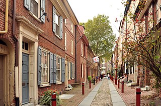
Historic districts in the United States are designated historic districts recognizing a group of buildings, archaeological resources, or other properties as historically or architecturally significant. Buildings, structures, objects, and sites within a historic district are normally divided into two categories, contributing and non-contributing. Districts vary greatly in size and composition: a historic district could comprise an entire neighborhood with hundreds of buildings, or a smaller area with just one or a few resources.

Pony is an unincorporated community and census-designated place in northeastern Madison County, Montana, United States, on the eastern edge of the Tobacco Root Mountains. As of the 2020 census, it had a population of 127. It includes the 192-acre (78 ha) Pony Historic District, a historic district with 95 contributing buildings listed on the National Register of Historic Places.
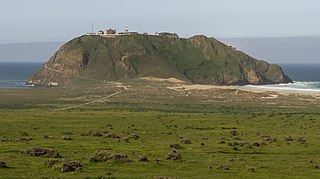
Point Sur State Historic Park is a California State Park on the Big Sur coastline of Monterey County, California, United States, 19 miles (31 km) south of Rio Road in Carmel. The 1889 Point Sur Lighthouse is on the National Register of Historic Places.
The Leinkauf Historic District is a historic district in the city of Mobile, Alabama, United States. It was placed on the National Register of Historic Places on June 24, 1987. It is roughly bounded by Government, Eslava, Lamar, and Monterey Streets. The district covers 1,100 acres (4.5 km2) and contains 303 contributing buildings. The buildings range in age from the 1820s to early 20th century and cover a variety of 19th- and 20th-century architectural styles.

The Newtown Borough Historic District is a 100-acre (40 ha) historic district in the borough of Newtown in Newtown, Connecticut. There is a local historic district and an overlapping district that was listed on the National Register of Historic Places in 1996.

The Old Custom House is the oldest surviving government building in California, built in 1827 by Mexican authorities in Monterey, then the capital of Alta California. The former custom house is the first designated California Historical Landmark, marking the site where U.S. Commodore John Drake Sloat raised the American flag and declared California part of the United States in 1846 during the American Conquest of California.

This is a list of the National Register of Historic Places listings in Monterey County, California.

There are 77 properties listed on the National Register of Historic Places in Albany, New York, United States. Six are additionally designated as National Historic Landmarks (NHLs), the most of any city in the state after New York City. Another 14 are historic districts, for which 20 of the listings are also contributing properties. Two properties, both buildings, that had been listed in the past but have since been demolished have been delisted; one building that is also no longer extant remains listed.

This is a list of the National Register of Historic Places listings in Van Wert County, Ohio.

The Fairmount Historic District is a 409-acre (166 ha) historic district located along County Route 517 in the Fairmount section of Tewksbury Township, near Califon, in Hunterdon County, New Jersey. It was added to the National Register of Historic Places on December 20, 1996 for its significance in architecture, exploration/settlement, and industry. The district includes 72 contributing buildings that were deemed to be contributing to the historic character of the area, plus five contributing structures, nine contributing sites, and one contributing object. One contributing building is located in Washington Township, Morris County.

Harbourton is an unincorporated community located within Hopewell Township in Mercer County, in the U.S. state of New Jersey. It is located along County Route 579 at the intersection with Harbourton-Mount Airy Road. The Harbourton Historic District, encompassing the community, was listed on the state and national registers of historic places in 1974.

The Tempe Wick Road–Washington Corners Historic District is a 353-acre (143 ha) historic district located in Harding Township and Mendham Township in Morris County, New Jersey. It extends along Tempe Wick Road from Mount Kemble Avenue to Cold Hill Road, and short segments of Corey Lane, Cemetery Road, Kennaday Road, Leddell Road, and Jockey Hollow Road. Tempe Wick Road is named for Temperance Wick.

Old Main Street Historic District is a nationally recognized historic district located in Dubuque, Iowa, United States. It was listed on the National Register of Historic Places in 1983. At the time of its nomination it consisted of 33 resources, which included 30 contributing buildings and three non-contributing buildings. In 2015 the boundaries were increased to include five more buildings. Four of the buildings are contributing properties that were excluded from the original district because they were slated to be torn down as a part of the expansion of U.S. Route 61. While the highway was built the buildings were spared. The fifth building is non-contributing as are three structures.
The Middle Reaches of Boone Creek Rural Historic District in the Clark County, Kentucky and Fayette County, Kentucky is a historic district which was listed on the National Register of Historic Places in 1996.

The Old Mine Road Historic District is a 687-acre (278 ha) historic district located along Old Mine Road in Sussex County and Warren County, New Jersey. It is part of the Delaware Water Gap National Recreation Area. The district was added to the National Register of Historic Places on December 3, 1980, for its significance in agriculture, archaeology, architecture, commerce, exploration/settlement, and transportation. It includes 24 contributing buildings and five contributing sites.

The Sunset Center is located in Carmel-by-the-Sea, California, United States. It is a performing arts center which features concerts, comedy, theatre, and dance. Formerly the Sunset School, the site was purchased by the city of Carmel in 1965 with the plan to develop it into a cultural center. It is home to the Carmel Bach Festival. It was listed on the National Register of Historic Places on January 9, 1998.
The Raritan–Readington South Branch Historic District is a 556-acre (225 ha) historic district along River Road from New Jersey Route 31 to U.S. Route 202 near Flemington in Hunterdon County, New Jersey. It is primarily on the western side of the South Branch Raritan River in Raritan Township. It extends onto the eastern side of the river in Readington Township. County Route 523 and County Route 612 pass through the district to the north. The district encompasses the small settlements of Holcomb Mills, Flemington Junction, and Rockefellows Mills. It was added to the National Register of Historic Places on January 26, 1990, for its significance in architecture, politics, transportation, and exploration/settlement. The district includes 36 contributing buildings, four contributing structures, and three contributing sites. It also includes the John Reading Farmstead, previously listed on the NRHP individually.

