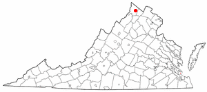
Moss Side (New Kent County, Virginia)

Last updated
Moss Side
USA Virginia location map.svg
Red pog.svg
Usa edcp location map.svg
Red pog.svg
Location 8501 State Route 249, vicinity of New Kent, Virginia
Coordinates 37°31′22″N77°3′17″W / 37.52278°N 77.05472°W / 37.52278; -77.05472 Coordinates: 37°31′22″N77°3′17″W / 37.52278°N 77.05472°W / 37.52278; -77.05472
Area 226 acres (91 ha)
Built ca. 1870
Architectural style I-house
NRHP reference # 100001046 [1]
Added to NRHP May 8, 2017

Moss Side is a historic farm property at 8501 Virginia State Route 249 in central New Kent County, Virginia. It now consists of about 226 acres (91 ha), whose centerpiece is a two-story wood-frame I-house built about 1870. Although this type of house was once quite common, it is a well-preserved example of the style, and is accompanied by a period outbuilding that probably functioned as either a guest house, kitchen, or tenant housing. Although the property's early history is dominated by the Christian family, these buildings date to the late 19th-century ownership by Henry Meyers, who gave the property its name. [2]

Virginia State Route 249 highway in Virginia

State Route 249 is a primary state highway in the U.S. state of Virginia. Known as New Kent Highway, the state highway runs 18.43 miles (29.66 km) from Interstate 64 (I-64) and SR 33 near Bottoms Bridge east to SR 33 and SR 30 at Angelview Church. According to signage on the segment of New Kent Highway between U.S. Route 60 and I-64, SR 249 extends slightly south from I-64 to end at US 60. SR 249, which is the old alignment of SR 33 before that highway was rerouted onto I-64, is the main local highway of northern New Kent County, providing access to the county seat of New Kent.

New Kent County, Virginia County in the United States

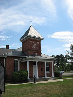
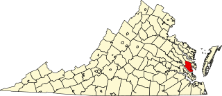
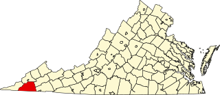
New Kent County is a county in the eastern part the Commonwealth of Virginia. As of the 2010 United States Census, the population was 18,429. Its county seat is New Kent.

The property was listed on the National Register of Historic Places in 2017. [1]

National Register of Historic Places federal list of historic sites in the United States

The National Register of Historic Places (NRHP) is the United States federal government's official list of districts, sites, buildings, structures, and objects deemed worthy of preservation for their historical significance. A property listed in the National Register, or located within a National Register Historic District, may qualify for tax incentives derived from the total value of expenses incurred preserving the property.

See also

National Register of Historic Places listings in New Kent County, Virginia Wikimedia list article

This is a list of the National Register of Historic Places listings in New Kent County, Virginia.

Related Research Articles

National Register of Historic Places listings in West Virginia Wikimedia list article

This is a list of properties and historic districts in West Virginia that are listed on the National Register of Historic Places. There are listings in every one of West Virginia's 55 counties.

National Register of Historic Places listings in Nevada Wikimedia list article

This is a list of properties and historic districts in Nevada that are listed on the National Register of Historic Places. There is at least one listing in each of Nevada's 16 counties and one independent city.

This is a list of the National Register of Historic Places listings in Grafton County, New Hampshire.

National Register of Historic Places listings in Belmont County, Ohio Wikimedia list article

This is a list of the National Register of Historic Places listings in Belmont County, Ohio.

National Register of Historic Places listings in Brunswick County, Virginia Wikimedia list article

This is a list of the National Register of Historic Places listings in Brunswick County, Virginia.

National Register of Historic Places listings in Hopewell, Virginia Wikimedia list article

This is a list of the National Register of Historic Places listings in Hopewell, Virginia.

National Register of Historic Places listings in Henrico County, Virginia Wikimedia list article

This is a list of the National Register of Historic Places listings in Henrico County, Virginia.

National Register of Historic Places listings in Pittsylvania County, Virginia Wikimedia list article

This is a list of the National Register of Historic Places listings in Pittsylvania County, Virginia.

National Register of Historic Places listings in Winchester, Virginia Wikimedia list article

This is a list of the National Register of Historic Places listings in Winchester, Virginia.

National Register of Historic Places listings in Gloucester County, Virginia Wikimedia list article

This is a list of the National Register of Historic Places listings in Gloucester County, Virginia.

National Register of Historic Places listings in Henry County, Virginia Wikimedia list article

This is a list of the National Register of Historic Places listings in Henry County, Virginia.

National Register of Historic Places listings in James City County, Virginia Wikimedia list article

This is a list of the National Register of Historic Places listings in James City County, Virginia.

National Register of Historic Places listings in Lancaster County, Virginia Wikimedia list article

This is a list of the National Register of Historic Places listings in Lancaster County, Virginia.

National Register of Historic Places listings in Prince William County, Virginia Wikimedia list article

This is a list of the National Register of Historic Places listings in Prince William County, Virginia.

National Register of Historic Places listings in Scott County, Virginia Wikimedia list article

This is a list of the National Register of Historic Places listings in Scott County, Virginia.

Windsor Shades building in Virginia, United States

Windsor Shades—also known as Ruffin's Ferry and Waterville—is situated on the Pamunkey River about 10 miles up river from West Point in King William County, Virginia. Archeological native artifacts found on the property surrounding the house suggest it was the site of the Kupkipcok, a Pamunkey village noted on John Smith's 1609 map.

Cedar Grove (Providence Forge, Virginia) human settlement in Virginia, United States of America

Cedar Grove is a historic plantation house located near Providence Forge, New Kent County, Virginia. The main section was built about 1810, and is a 2 1/2-story, single pile, brick structure. The frame section was added about 1916. It has a traditional one-room side-hall plan. Also on the property are a contributing smokehouse and several sheds added about 1916. It was the farm residence of the Christians, a leading county family of colonial and early-Republican times. The 19th-century cemetery contains the graves of the Christian family, including Letitia Christian Tyler, the first wife of President John Tyler.

Cedar Lane (New Kent, Virginia)

Cedar Lane is a historic farm property at 9040 Virginia State Route 249 in central New Kent County, Virginia. Built about 1782, it is one of the county's better examples of early Federal period architecture. It is a two-story frame structure, with a gabled roof and clapboarded exterior. An open hip-roofed porch extends across the front of the main block, which is flanked by two-story and one-story wings. It was probably built by either William Poindexter or by his daughter Ann and her husband Thomas Howle, and achieved much of its present form by 1860.

Cumberland (New Kent, Virginia)

Cumberland is a historic farm property at 9007 Cumberland Road in central northern New Kent County, Virginia. The property, now about 131 acres (53 ha), was once the centerpiece of a much larger plantation estate. The main house has a construction history dating to the 18th century, and includes a number of interior features from that period. The exterior is largely the product of a 1930s update of the property to a design by Harden de Valsen Pratt, a major restoration architect. Other historic elements of the property include a barn and the family cemetery of the Toler and Fauntleroy families, who owned the property for over a century.

References

  1. 1 2 National Park Service (2008-04-15). "National Register Information System". National Register of Historic Places . National Park Service.
  2. "NRHP nomination for Moss Side" (PDF). Virginia DHR. Retrieved 2017-10-22.