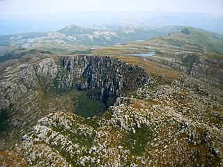
Mount Field West | |
---|---|
Mount Field West is the peak on the far left | |
Highest point | |
Elevation | 1,434 m (4,705 ft) AHD [1] |
Prominence | 981 m (3,219 ft) [1] |
Isolation | 68.92 km (42.82 mi) [1] |
Coordinates | 42°39′19″S146°35′15″E / 42.65528°S 146.58750°E |
Geography | |
Location in Tasmania | |
Location | Tasmania, Australia |
Mount Field West is a mountain in the western portion of Mount Field National Park in the southern region of Tasmania, Australia.
A mountain is a large landform that rises above the surrounding land in a limited area, usually in the form of a peak. A mountain is generally steeper than a hill. Mountains are formed through tectonic forces or volcanism. These forces can locally raise the surface of the earth. Mountains erode slowly through the action of rivers, weather conditions, and glaciers. A few mountains are isolated summits, but most occur in huge mountain ranges.
Mount Field National Park is a national park in Tasmania, Australia, 64 km northwest of Hobart. The landscape ranges from eucalyptus temperate rainforest to alpine moorland, rising to 1,434 metres (4,705 ft) at the summit of Mount Field West.
Tasmania is an island state of Australia. It is located 240 km (150 mi) to the south of the Australian mainland, separated by Bass Strait. The state encompasses the main island of Tasmania, the 26th-largest island in the world, and the surrounding 334 islands. The state has a population of around 533,308 as of March 2019. Just over forty percent of the population resides in the Greater Hobart precinct, which forms the metropolitan area of the state capital and largest city, Hobart.
The mountain is frequently snow-covered, sometimes even in summer. It is a major feature of the national park, and is a popular destination for bushwalkers. It overlooks Upper Florentine Valley and is a 7.5 hour return walk from Lake Dobson.
The Upper Florentine Valley, in the south of Tasmania, Australia, is an area recognised for its landscape and old growth forests. It is situated along the Gordon River Road near Maydena in the southwest of the island, roughly three hours drive from Hobart and comprises around 60 square kilometres (23 sq mi) of temperate rainforest. The Upper Florentine forms part of the Florentine catchment upstream (south) from Churchill Creek and lies just outside the World Heritage Area. Geographically it is an area of generally low relief valleys and flats. The area is a known habitat for threatened species of flora and fauna, including sallow wattle, myrtle elbow orchid, grey goshawk, and spotted-tail quoll.
Mount Field West rises to 1,434 metres (4,705 ft) above sea level, [1] making it within the forty highest peaks in Tasmania.
The Australian Height Datum is a vertical datum in Australia. According to Geoscience Australia, "In 1971 the mean sea level for 1966-1968 was assigned the value of 0.000m on the Australian Height Datum at thirty tide gauges around the coast of the Australian continent. The resulting datum surface, with minor modifications in two metropolitan areas, has been termed the Australian Height Datum (AHD) and was adopted by the National Mapping Council as the datum to which all vertical control for mapping is to be referred."
Mount Huxley is a mountain located on the West Coast Range in the West Coast region of Tasmania, Australia. With an elevation of 926 metres (3,038 ft) above sea level, the mountain was named by Charles Gould in 1863 in honour of Professor Thomas Henry Huxley.
Mount Darwin is a mountain located in the West Coast region of Tasmania, Australia.
Mount Sorell is a mountain located in the West Coast region of Tasmania, Australia.
Mount Sedgwick is a mountain located within the West Coast Range, in the West Coast region of Tasmania, Australia.
Mount Mawson is a mountain and club skifield situated within the Mount Field National Park in southern Tasmania, Australia.
Mount Dundas is a mountain located in the West Coast region of Tasmania, Australia. The mountain is situated at the north west edge of the West Coast Range.
Mount Geikie is a mountain in the West Coast Range of Western Tasmania, Australia.
Mount Pelion West is a mountain located in the Central Highlands region of Tasmania, Australia. The mountain is part of the Pelion Range and is situated within the Cradle Mountain-Lake St Clair National Park at the eastern most boundary of the Murchison River catchment.
Mount Pelion East is a mountain located in the Central Highlands region of Tasmania, Australia. The mountain is situated within the Cradle Mountain-Lake St Clair National Park.
The Du Cane Range is a mountain range in the Central Highlands region of Tasmania, Australia.
Mount Massif is a mountain in the Central Highlands region of Tasmania, Australia. Situated in the Cradle Mountain-Lake St Clair National Park, the mountain is part of the Du Cane Range.
Mount Geryon is a mountain in the Central Highlands region of the Australian state of Tasmania. The mountain is part of the Du Cane Range and is situated within the Cradle Mountain-Lake St Clair National Park.
Mount Gould is a mountain in the Central Highlands region of Tasmania, Australia. Situated within the Cradle Mountain-Lake St Clair National Park, the mountain is a major feature of the national park, and is a popular venue with bushwalkers and mountain climbers.
Mount Thetis is a mountain in the Central Highlands region of Tasmania, Australia. It is part of the Pelion Range and is situated within the Cradle Mountain-Lake St Clair National Park. It is a major feature of the national park, and is a popular venue with bushwalkers and mountain climbers.
Mount Anne is a mountain located in the Southwest National Park in south-west region of Tasmania, Australia. The mountain lies within the UNESCO World Heritage-listed Tasmanian Wilderness.
Mount Achilles is a mountain that is part of the Du Cane Range, located in the Cradle Mountain-Lake St Clair National Park in Tasmania, Australia. With an elevation of 1,353 metres (4,439 ft) above sea level, the peak is the 46th highest mountain in Tasmania.
Mount Victoria is a mountain in the Mount Victoria Forest Reserve in north-east Tasmania, Australia, and also forms part of the Ben Lomond biogeographic region and the Ben Lomond National Park. The peak has an elevation of 1,213 metres (3,980 ft) above sea level and is the 58th highest mountain in Tasmania. It is a prominent feature of the reserve, and is a popular venue with bushwalkers.
The Pelion Range is a mountain range in the Cradle Mountain-Lake St Clair National Park, Tasmania, Australia.
The Tyndall Range, commonly called The Tyndalls, is a mountain range that is part of the West Coast Range located in the Western region of Tasmania, Australia.
This Tasmania geography article is a stub. You can help Wikipedia by expanding it. |