
Tower of Set is a 6,012-foot-elevation (1,832-meter) summit located in the Grand Canyon, in Coconino County of Arizona, US. This butte is situated four miles north of Hopi Point overlook on the canyon's South Rim, two miles southeast of Tower of Ra, and three miles south-southwest of Shiva Temple, where it towers 3,600 feet above the Colorado River. Tower of Set was originally named Temple of Sett in 1879 by Thomas Moran, for the Egyptian deity of war, Set, because a niche worn into its wall evoked temples in the valley of the Nile. Another source states it was named by George Wharton James, in keeping with Clarence Dutton's tradition of naming geographical features in the Grand Canyon after mythological deities. This mountain's name was officially adopted in 1906 by the U.S. Board on Geographic Names. In 1919, Harriet Williams Russell Strong proposed connecting Hopi Point and Tower of Set across the river via an aerial tramway, an idea that never came to fruition. The first ascent was made in November 1977 by Bruce Grubbs and Jim Haggart. According to the Köppen climate classification system, Tower of Set is located in a cold semi-arid climate zone.

Tower of Ra is a 6,129-foot-elevation (1,868-meter) pillar located in the Grand Canyon, in Coconino County of Arizona, US. Its summit is situated five miles north of Pima Point overlook on the canyon's South Rim, three miles southeast of Confucius Temple, and two miles northwest of Tower of Set, where it towers over 3,700 feet above the Colorado River. Tower of Ra was named in 1879 by Thomas Moran, for Ra, the Egyptian deity of the sun. This followed the naming convention of Clarence Dutton who began the tradition of naming geographical features in the Grand Canyon after mythological deities. This mountain's name was officially adopted in 1906 by the U.S. Board on Geographic Names. The first ascent was made in 1977 by Jim Haggart, Art Christiansen, and Barbara Zinn. According to the Köppen climate classification system, Tower of Ra is located in a cold semi-arid climate zone.

Dox Castle is a 4,780-foot-elevation (1,460-meter) summit located in the Grand Canyon, in Coconino County of northern Arizona, US. It is situated four miles north-northeast of Havasupai Point, two miles northwest of Evans Butte, and 2.5 miles southwest of Holy Grail Temple, where it towers 2,500 feet above the Colorado River.

Holy Grail Temple is a 6,711-foot-elevation (2,046-meter) summit located in the Grand Canyon, in Coconino County of northern Arizona, US. It is situated seven miles north-northeast of Havasupai Point, and two miles west-northwest of King Arthur Castle, within the Shinumo Amphitheater. Topographic relief is significant as it rises over 4,500 feet above the Colorado River in three miles. According to the Köppen climate classification system, Holy Grail Temple is located in a cold semi-arid climate zone, with precipitation runoff draining south to Shinumo Creek, which flows west to the Colorado River.

Coronado Butte is a 7,162-foot (2,183 m)-elevation summit located in the Grand Canyon, in Coconino County of Arizona, United States. It is situated one mile (1.6 km) west of the Moran Point overlook on the canyon's South Rim, and one mile northeast of Sinking Ship, its nearest higher neighbor. Topographic relief is significant as this butte rises 4,600 feet (1,400 m) above the Colorado River in 2.5 miles (4.0 km). Coronado Butte is named for Francisco Vázquez de Coronado (1510–1554), the explorer whose 1540 expedition was the first European sighting of the Grand Canyon, among other landmarks. This geographical feature's name was officially adopted in 1906 by the U.S. Board on Geographic Names. The first ascent was made by John Hance and tourist prior to 1900, in the 1890s. According to the Köppen climate classification system, Coronado Butte is located in a cold semi-arid climate zone.

Apollo Temple is a 6,252-foot-elevation (1,906-meter) summit located in the Grand Canyon, in Coconino County of northern Arizona, in the southwestern United States. It is situated four miles due east of Cape Royal on the canyon's North Rim, four miles northeast of Vishnu Temple, and a half-mile south-southeast of Venus Temple, which is the nearest higher neighbor. Topographic relief is significant as it rises over 3,600 feet above the Colorado River in less than two miles.

Chuar Butte is a prominent 6,500-foot-elevation (2,000-meter) summit located in the Grand Canyon, in Coconino County of northern Arizona, US. It is situated 1.5 miles northwest of Cape Solitude on the canyon's East Rim, three miles southeast of Gunther Castle, and immediately west of the confluence of the Colorado River and Little Colorado River. This position also places it where Marble Canyon ends, and the Grand Canyon begins. Topographic relief is significant as it rises nearly 3,800 feet above the river in less than one mile. According to the Köppen climate classification system, Chuar Butte is located in a cold semi-arid climate zone.

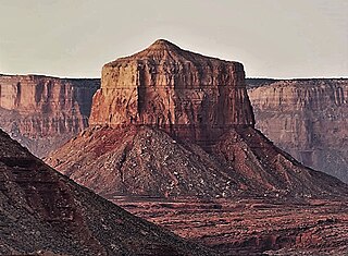
Gunther Castle is a 7,199-foot-elevation (2,194-meter) summit located in the Grand Canyon, in Coconino County of northern Arizona, US. It is situated three miles northwest of Chuar Butte, between Kwagunt Valley to the north, and Chuar Valley to the south. Topographic relief is significant as it rises nearly 4,500 feet above the Colorado River in three miles.

Steamboat Mountain is a 7,410-foot-elevation (2,260-meter) summit located in the Grand Canyon, in Coconino County of northern Arizona, US. It is situated four miles northwest of Holy Grail Temple, and 2.5 miles west-southwest of Timp Point on the North Rim. George Wharton James described it as a "majestic butte", nearly encircled by Galloway and Saddle Canyons. Topographic relief is significant as it rises over 5,400 feet above the Colorado River in three miles. According to the Köppen climate classification system, Steamboat Mountain is located in a Cold semi-arid climate zone, with precipitation runoff draining west to the Colorado River via Tapeats Creek and Stone Creek. This feature's name was officially adopted in 1932 by the U.S. Board on Geographic Names.
Mount Sinyella is a 5,441-foot-elevation (1,658 meter) summit located in the western end of Grand Canyon National Park, in Coconino County of northern Arizona, US. It is situated 1.7 mile north-northwest of Uqualla Point, and four miles southeast of Boysag Point, at the mouth of Havasu Canyon. As the high point of Sinyella Mesa, it towers 1,200 feet above the mesa, and 3,600 feet above the nearby Colorado River which is 1.5 mile to the northwest.

Manu Temple is a 7,184-foot-elevation (2,190-meter) summit located in the Grand Canyon, in Coconino County of northern Arizona, United States. It is situated one mile south of the North Rim's Widforss Point, 1.5 miles (2.4 km) northeast of parent Buddha Temple, and three miles southwest of the North Rim's Bright Angel Point. Topographic relief is significant as it rises nearly 3,600 feet in two miles above Bright Angel Canyon to the east, and 2,200 feet in less than one mile above Haunted Canyon to the immediate west. Its neighbors include Brahma Temple and Deva Temple to the east on the opposite side of Bright Angel Canyon. From the South Rim of the canyon it may be difficult to discern Manu Temple from the walls of the Kaibab Plateau one mile behind it, but when the lighting and atmosphere are favorable, this butte of great proportions can be seen clearly defined.

Castor is a 6,221-foot-elevation (1,896-meter) summit located in the Grand Canyon, in Coconino County of northern Arizona, United States. It is situated 11 miles west-northwest of Grand Canyon Village, and less than one mile north of Piute Point. Pollux Temple is one mile southeast, and Geikie Peak is three miles to the east. Topographic relief is significant as Castor Temple rises over 3,800 feet above the Colorado River in two miles.

King Arthur Castle is a 7,344-foot-elevation (2,238-meter) summit located in the Grand Canyon, in Coconino County of northern Arizona, US. It is situated one-half mile northwest of Guinevere Castle, one mile west of Excalibur, and two miles east-southeast of Holy Grail Temple, within the Shinumo Amphitheater. Topographic relief is significant as it rises over 5,100 feet above the Colorado River in 4.5 miles (7.2 km). According to the Köppen climate classification system, King Arthur Castle is located in a cold semi-arid climate zone, with precipitation runoff draining west to the Colorado River via Shinumo Creek.

Sinking Ship is a 7,344-foot (2,238 m) elevation summit located in the Grand Canyon, in Coconino County of northern Arizona, United States. This butte is situated 1.7 miles (2.7 km) southeast of the Grandview Point overlook on the canyon's South Rim, and 1.25 miles (2.01 km) southwest of Coronado Butte. Topographic relief is significant as it rises 4,800 feet (1,500 m) above the Colorado River in 4 miles (6.4 km). According to the Köppen climate classification system, Sinking Ship is located in a cold semi-arid climate zone.

Masonic Temple is a 6,242-foot-elevation (1,903-meter) summit located in the Grand Canyon, in Coconino County of northern Arizona, US. Set below Dutton Point on the Powell Plateau, and overlooking the Shinumo Amphitheater, it is situated three miles west of Holy Grail Temple, 2.7 miles northwest of Dox Castle, and 1.6 miles north-northeast of Fan Island. Topographic relief is significant as it rises 4,000 feet above the Colorado River in four miles (6.4 km). According to the Köppen climate classification system, Masonic Temple is located in a cold semi-arid climate zone, with precipitation runoff draining south to the Colorado River via Hakatai Canyon from the west aspect, Burro Canyon from the south aspect, and Muav Canyon from the east aspect. This butte is an erosional remnant composed of strata of the Pennsylvanian-Permian Supai Group overlaying the conspicuous cliffs of Mississippian Redwall Limestone, in turn overlaying the Cambrian Tonto Group.
Guinevere Castle is a 7,281-foot-elevation (2,219 meter) summit located in the Grand Canyon, in Coconino County of northern Arizona, US. It is situated one-half mile southeast of King Arthur Castle, one mile west of Excalibur, and 2.5 miles northeast of Evans Butte, within the Shinumo Amphitheater. Topographic relief is significant as it rises 5,000 feet above the Colorado River in 4.5 miles, and 2,600 feet above Gawain Abyss in one mile. According to the Köppen climate classification system, Guinevere Castle is located in a cold semi-arid climate zone.

Huxley Terrace is a narrow, linear mesa-like platform extending northeast from Mount Huethawali in western Grand Canyon on the South Rim;. Three landforms surround Mount Huethawali; the Darwin Plateau extends southwest ; two terraces are at the north of Huethawali, Spencer Terrace extends north-northwest, and Huxley Terrace extends northeast.
Elaine Castle is a 7,431-foot-elevation (2,265 meter) summit located in the Grand Canyon, in Coconino County of northern Arizona, US. It is situated three miles north-northwest of King Arthur Castle near the head of Shinumo Creek, and immediately southwest of Lancelot Point. Topographic relief is significant as it rises 2,800 feet above Merlin Abyss in one mile. According to the Köppen climate classification system, Elaine Castle is located in a cold semi-arid climate zone.

Kibbey Butte is a 7,801-foot-elevation (2,378-meter) summit located in the Grand Canyon, in Coconino County of northern Arizona, US. It is situated two miles south of the Point Imperial viewpoint on the canyon's North Rim, where it towers over 3,000 feet above Nankoweap Canyon. Its nearest higher neighbor is Brady Peak one mile to the southeast, Hancock Butte is one mile to the north-northeast, and Alsap Butte is two miles to the east. The summit of this butte is composed of dark reddish Permian Hermit Shale overlaying the Pennsylvanian-Permian Supai Group, in turn overlaying the cliff-forming Mississippian Redwall Limestone. According to the Köppen climate classification system, Kibbey Butte is located in a cold semi-arid climate zone. Precipitation runoff from this feature drains east into the Colorado River via Nankoweap Creek. Cross-country access to Kibbey Butte starts at the parking area for Greenland Lake. The first ascent of the summit was made by Harvey Butchart and Allyn Cureton on May 31, 1961.

Colter Butte is a 7,254-foot-elevation (2,211-meter) summit located in the Grand Canyon in Coconino County of northern Arizona, US. It is situated four miles southeast of Point Imperial, where it towers 3,600 feet above Nankoweap Canyon. Its neighbors include Brady Peak, 2.5 miles to the west-northwest, Alsap Butte two miles to the northwest, and Swilling Butte one-half mile to the east. Colter Butte is named after James G. H. Colter (1844–1922), born in Nova Scotia, Canada, he came to the Arizona Territory in 1872 as a pioneer, farmer, cattleman, Apache and desperado fighter. He was the father of Arizona state senator Fred Colter. This geographical feature's name was officially adopted in 1932 by the United States Board on Geographic Names. According to the Köppen climate classification system, Colter Butte is located in a cold semi-arid climate zone. This butte is composed of Pennsylvanian-Permian Supai Group which overlays cliff-forming Mississippian Redwall Limestone, which in turn overlays slope-forming Cambrian Tonto Group. Precipitation runoff from this feature drains east to the Colorado River via Nankoweap Creek on the north side and Kwagunt Creek from the south slope.


