
Sevierville is a city in and the county seat of Sevier County, Tennessee, United States, located in eastern Tennessee. The population was 17,889 at the 2020 United States Census.

Jericho is a town in Chittenden County, Vermont, United States. As of the 2020 census, the population was 5,104. The town was named after the ancient city of Jericho.
Fond du Lac is a city in and the county seat of Fond du Lac County, Wisconsin, United States, located at the southern end of Lake Winnebago. The population was 44,678 at the 2020 census. The city forms the core of the Fond du Lac metropolitan statistical area, which includes all of Fond du Lac County and had 104,154 residents in 2020.

This is a list of sites in Minnesota which are included in the National Register of Historic Places. There are more than 1,700 properties and historic districts listed on the NRHP; each of Minnesota's 87 counties has at least 2 listings. Twenty-two sites are also National Historic Landmarks.

Bay View is a neighborhood in Milwaukee, Wisconsin, United States, North America on the shores of Lake Michigan, south of the downtown area and north of the City of St. Francis. Bay View existed as an independent village for eight years, from 1879 to 1887.

Claude and Starck was an architectural firm in Madison, Wisconsin, at the turn of the twentieth century. The firm was a partnership of Louis W. Claude (1868-1951) and Edward F. Starck (1868-1947). Established in 1896, the firm dissolved in 1928. The firm designed over 175 buildings in Madison.

Copper Culture State Park is a 42-acre (17 ha) Wisconsin state park in Oconto, northeastern Wisconsin, United States. The park has natural areas, farmlands, archaeological sites, and a Native American museum.

First Church of Christ, Scientist, also known as First Christian Science Church Edifice, is a church building located in Oconto, Wisconsin. Built in 1886 of stone, weatherboard and brick in the Gothic Revival style, it was the first purpose-built Christian Science church edifice in the world. It was added to the National Register of Historic Places in 1974.

This is a list of the National Register of Historic Places listings in Brown County, Wisconsin. It is intended to provide a comprehensive listing of entries in the National Register of Historic Places that are located in Brown County, Wisconsin. The locations of National Register properties for which the latitude and longitude coordinates are included below may be seen in a map.
This is a list of the National Register of Historic Places listings in Iowa County, Wisconsin. It is intended to provide a comprehensive listing of entries in the National Register of Historic Places that are located in Iowa County, Wisconsin. The locations of National Register properties for which the latitude and longitude coordinates are included below may be seen in a map.

This is a list of the National Register of Historic Places listings in Oconto County, Wisconsin. It is intended to provide a comprehensive listing of entries in the National Register of Historic Places that are located in Oconto County, Wisconsin. The locations of National Register properties for which the latitude and longitude coordinates are included below may be seen in a map.

This is a list of the National Register of Historic Places listings in Marinette County, Wisconsin. It is intended to provide a comprehensive listing of entries in the National Register of Historic Places that are located in Marinette County, Wisconsin. The locations of National Register properties for which the latitude and longitude coordinates are included below may be seen in a map.

Washington Avenue Historic District is the historic center of Cedarburg, Wisconsin, the location of the early industry and commerce that was key to the community's development. The historic district was listed on the National Register of Historic Places (NRHP) in 1986.

St. Mark's Episcopal Church, Guild Hall and Vicarage is a historic Episcopal church complex in Oconto, Wisconsin, with its buildings in architectural styles popular when they were constructed. The complex was added to the National Register of Historic Places on August 1, 1985 for its architectural significance.

St. Peter's and St. Joseph's Catholic Churches are two historic Catholic churches in Oconto, Wisconsin, United States, both built in the 1890s. On November 10, 1980, they were added together to the National Register of Historic Places.
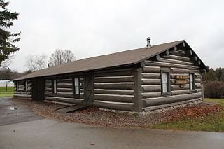
The Holt and Balcom Logging Camp No. 1 in Lakewood, Wisconsin was built around 1880 in what was then timber along McCaslin Brook. It is probably the oldest lumber camp in Wisconsin still standing in its original location, and was added to the National Register of Historic Places in 1978.
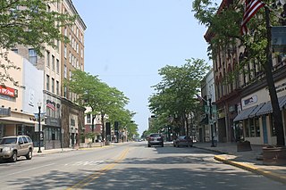
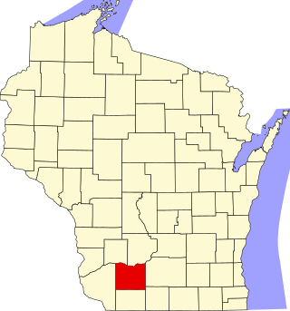
John Hawkins Rountree was an American farmer, businessman, politician, and Wisconsin pioneer. He was the founder of Platteville, Wisconsin, and was instrumental in the early development of that village. He was also one of the founders of the Northwestern Mutual Insurance Company, and remained a director in the company until his death. In politics, he represented Grant County for five years in the Wisconsin Legislature, and was a delegate to Wisconsin's 2nd constitutional convention in 1847.

This is a list of the National Register of Historic Places listings in Shawano County, Wisconsin. It is intended to provide a comprehensive listing of entries in the National Register of Historic Places that are located in Shawano County, Wisconsin. The locations of National Register properties for which the latitude and longitude coordinates are included below may be seen in a map.
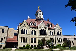
The Oconto County Courthouse is a county courthouse in Oconto, Wisconsin, United States. It houses the circuit court and government offices of Oconto County, Wisconsin. The courthouse was built in 1891, with major alterations in 1907 and 1963. It was listed on the National Register of Historic Places in 1982 and the state register of historic places in 1989 for its local architectural significance.


