
The Murray River is a river in south-eastern Australia. It is Australia's longest river at 2,508 km (1,558 mi) extent. Its tributaries include five of the next six longest rivers of Australia. Together with that of the Murray, the catchments of these rivers form the Murray-Darling basin, which covers about one-seventh the area of Australia. It is widely considered Australia's most important irrigated region.

Echuca is a town on the banks of the Murray River and Campaspe River in Victoria, Australia. The border town of Moama is adjacent on the northern side of the Murray River in New South Wales. Echuca is the administrative centre and largest settlement in the Shire of Campaspe. As at June 2018 Echuca had a population of 14,934, and the population of the combined Echuca and Moama townships was 21,242 at the same time. Echuca is the home of the football team the Echuca Rockets.

The Rural City of Mildura is a local government area in Victoria, Australia, located in the north-western part of the state. It covers an area of 22,083 square kilometres (8,526 sq mi) being the largest LGA in the state. In June 2016 the area had a population of 53,878. It includes the city of Mildura and the towns of Merbein, Red Cliffs, Irymple, Ouyen, Werrimull, Murrayville, Walpeup and Hattah. It was formed in 1995 from the amalgamation of the City of Mildura, Shire of Mildura and Shire of Walpeup.

Mildura is a regional city in north-west Victoria, Australia. Located on the Victorian side of the Murray River, Mildura had a population of 33,444 in 2016. When nearby Wentworth, Irymple, Nichols Point and Merbein are included, the area had an estimated urban population of 51,903 at June 2018, having grown marginally at an average annual rate of 0.88% year-on-year over the preceding five years. It is the largest settlement in the Sunraysia region. Mildura is a major horticultural centre notable for its grape production, supplying 80% of Victoria's grapes. Many wineries also source grapes from Mildura.
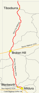
The Silver City Highway is a 683-kilometre-long (424 mi) highway that links Buronga, New South Wales to the Queensland border via Wentworth, Broken Hill, and Tibooburra, in the arid Far West region of New South Wales. A short branch also connects to the Calder Highway on the Victorian border at Curlwaa. This branch is also signed as the Calder Highway, despite legally being part of the Silver City Highway. Parts of the highway north of Tibooburra are unsealed. The namesake of the highway is derived from the moniker for Broken Hill–the "Silver City", which the highway travels through.

Wentworth is a small border town in the far south west of the state of New South Wales, Australia. It lies at the confluence of Australia's two most important rivers, the Darling and the Murray, the latter forming the border with the state of Victoria to the south. The border with the state of South Australia lies approximately 100 kilometres (62 mi) to the west. The town of Wentworth is in the local government area of the same name.

The Sturt Highway is an Australian national highway in New South Wales, Victoria, and South Australia. The Sturt Highway is an important road link for the transport of passengers and freight between Sydney and Adelaide and the regions situated adjacent to the route.
The Sunraysia is an ill–defined district, sometimes incorrectly referred to as an economic region, located in northwestern Victoria and southwestern New South Wales in Australia. The region is renowned for its sunshine, intensive horticulture including grapes and oranges, and grain farms. Its main centre is Mildura, Victoria.

The Riverland is a region of South Australia. It covers an area of 9,386 square kilometres (3,624 sq mi) along the Murray River from where it flows into South Australia from New South Wales and Victoria downstream to Blanchetown. The major town centres are Renmark, Berri, Loxton, Waikerie, Barmera and Monash, along with many minor townships; the population is approximately 35,000 people.

Merbein is a town just north of Mildura, Victoria, in the Sunraysia region of Australia. It is on the Calder Highway between Mildura and the Murray River crossing at the Abbotsford Bridge to Curlwaa. At the 2016 census, the town had a population of 1,981. Merbein is 12 kilometres from Mildura, 553 km from Melbourne and 389 km from Adelaide.

Nangiloc is a small rural community in North Western Victoria on the south (left) bank of the Murray River, about 50 km south east of Mildura. Primarily an agricultural settlement, at the 2016 census, Nangiloc and the surrounding area had a population of 141.
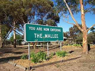
The Mallee covers the most northwesterly part of Victoria, bounded by the South Australian and New South Wales borders. Definitions of the south-eastern boundary vary, however, all are based on the historic Victorian distribution of mallee eucalypts. These trees dominate the surviving vegetation through most of Mallee,. Its biggest settlements are Mildura and Swan Hill.

Buronga is a town in New South Wales, Australia on the Murray River. The George Chaffey Bridge connects Buronga with Mildura, Victoria. In 2011, the town had a population of 1132 people.

Swan Hill is a city in the northwest of Victoria, Australia on the Murray Valley Highway and on the south bank of the Murray River, downstream from the junction of the Loddon River. At June 2018, Swan Hill had a population of 11,103.

Langhorne Creek is a town in South Australia. At the 2016 census, Langhorne Creek had a population of 427.

Abbotsford Bridge is a steel Allan truss-type road bridge that carries the Silver City Highway across the Murray River, between Curlwaa in New South Wales, and Yelta in Victoria, Australia. It is the only remaining steel truss bridge with a lift span that crosses the Murray. Opened in 1928, the bridge was built by the NSW Department of Public Works and was designed by Percy Allan. It was the second last vertical-lift bridge to be built over the river, the last being the Nyah Bridge, which opened in 1941.

The Renmark Paringa Council is a local government area located adjacent to the Victorian border, in the Riverland, South Australia. The area is known for its various fruit production, and is heavily dependent on the River Murray as a water source. The council seat is at Renmark.
Murray Darling is a wine region and Australian Geographical Indication which spans the Murray River and its confluence with the Darling River in northwestern Victoria and southwestern New South Wales. It was registered as a protected name on 16 June 1997.

Cape Mentelle Vineyards is a wine estate located in the Margaret River region, 274 km south-west of Perth, Western Australia. The winery was founded by David Hohnen, a third-generation farmer who studied wine making and viticulture in California in the 1960s and his brothers Mark and Giles. Cape Mentelle is one of the ‘founding five’ wineries in Margaret River and is well known for producing Cabernet Sauvignon and Chardonnay in the region. The winery was established in 1970 and came to prominence by winning the Jimmy Watson Memorial Trophy in both 1983 and 1984 for their Cabernet sauvignon.

The George Chaffey Bridge is a road bridge in Australia that carries the Sturt Highway across the Murray River from Buronga to Mildura.

