Mthwalume

Last updated

Mtwalume
Umtalumi
South Africa KwaZulu-Natal location map.svg
Red pog.svg
Mtwalume
South Africa adm location map.svg
Red pog.svg
Mtwalume
Coordinates: 30°28′59″S30°37′59″E / 30.483°S 30.633°E
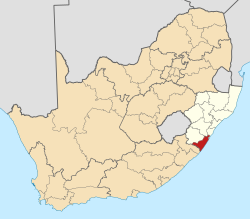
 / -30.483; 30.633
Country South Africa
Province KwaZulu-Natal
District Ugu
Municipality Umzumbe
Area
[1]
  Total2.89 km2 (1.12 sq mi)
Population
 (2011) [1]
  Total610
  Density210/km2 (550/sq mi)
Racial makeup (2011)
[1]
   Black African 18.0%
   Coloured 2.3%
   Indian/Asian 4.9%
   White 74.6%
  Other0.2%
First languages (2011)
[1]
   Afrikaans 42.4%
   English 41.4%
   Zulu 12.6%
   Xhosa 2.0%
  Other1.6%
Time zone UTC+2 (SAST)
PO box
4186
Area code 039

Mtwalume, also known as Umtalumi, is a settlement in Ugu District Municipality in the KwaZulu-Natal province of South Africa.

Contents

A small seaside village about 87 km south of Durban, it is predominantly a holiday and fishing village. The name "Mtwalume" is derived from isiZulu, and refers to the tall upright trees growing on the river bank. The Mtwalume River winds for 85 km and ends in a waterfall near Highflats. [2]

Mtwalume is largely made up of rural, but modern villages. The majority of the Mtwalume land area falls under the traditional chieftaincy of iNkosi Bhekizizwe Luthuli whose residency is near Turton. Some of the well-known Mtwalume villages lie along the Indian Ocean coast. These villages are Mnafu, Turton, Makhoso and Gobhela. Inland villages include eNyangwini, Nomakhanzane, Dingimbiza, eMabheleni, KwaQoloqolo, Othandweni, Nomoyi and Bangibizo. Mtwalume is bordered on the north by Efafa - another coastal town - and on the south by Hibberdene.

UMTWALUMI postmark in 1904 1904 1d Natal Umtwalumi Yv58 Mi59 SG128 carmine.jpg
UMTWALUMI postmark in 1904

Population and culture

The majority of Mtwalume falls under the municipal jurisdiction of Umzumbe Local Municipality, while a small portion that is sea-facing falls under Umdoni Local Municipality. The majority of Mtwalume residents are Zulu people who speak the Zulu dialect. There is a limited White population along the suburban coastal parts of Mtwalume. The most dominant culture is traditional Zulu and Christian, as most of the residents uphold Christian faith and values. Some of the well-established Christian denominations in Mtwalume are Apostolic Church Southern Africa, Assemblies of God, Faith Mission, Roman Catholic Church, and United Congregational Church.

Education

There are a number of primary and secondary schools in Mtwalume, and they largely teach in isiZulu and English. Some of the primary schools are Esbanini Primary School (in eNyangwini), KwaNomakhanzane Primary School, Bangibizo Primary School, Mandlendoda Primary School (in Turton), Gobhela Primary School, KwaBhavu Primary School (in Othandweni) and Wilder Primary School (in KwaQoloqolo). Secondary (i.e. high) schools include Luthuli High School (in Turton), Mthwalume High School (in KwaQoloqolo), KwaFica Secondary School (in Bangibizo), Zibonele Secondary School (in KwaNomakhanzane) and Bonguzwane Secondary School (in eNyangwini).

Transport, housing and other infrastructure

Most of the inland roads are gravel although tar roads dominate the coastal areas. People largely use taxis and buses. The main taxi rank is found in Turton at the intersection of Sipofu Road and R102. There is also a significant percentage of people who own cars. Most of these people are teachers, health professionals, police and other workers. The working population (outside of teachers, police and health workers) work in the nearby towns of Port Shepstone, Margate, Shelly Beach, Hibberdene, Umzinto and Scottburgh. Some people work as far as Durban.

The Turton Community Clinic now Mfundo Arnold Lushaba Community Health Centre is the only known health clinic in Mtwalume. It is located together with the offices of Umzumbe Local Municipality offices. For hospitals, residents of Mtwalume normally use the Port Shepstone Regional Hospital and the Scottburgh's GJ Crookes Hospital. Msinsini Police Station is the only South African Police Service security facility in the area now with a satellite office next to the Clinic serviced under Hibberdene Police Station.

Related Research Articles

KwaDukuza, previously known as Stanger, is a city in KwaZulu-Natal, South Africa. In 2006, the municipal name was changed to KwaDukuza, but the Zulu people in the area called it "Dukuza" well before then.

<span class="mw-page-title-main">Margate, South Africa</span> Resort town in KwaZulu-Natal, South Africa

Margate is a coastal resort town in the KwaZulu-Natal province, about 20 kilometres south-west of Port Shepstone and 127 kilometres south-west of Durban. The river which flows into the sea at Margate is called "Nkhongweni" (place of entreaty) as the original inhabitants of the area were reputed to be so mean resulting in travellers begging for hospitality.

<span class="mw-page-title-main">Port Shepstone</span> Coastal town in KwaZulu-Natal, South Africa

Port Shepstone is a large town situated on the mouth of the Mzimkhulu River, the largest river on the KwaZulu-Natal South Coast of South Africa. It is located halfway between Hibberdene and Margate and is positioned 120 km south of Durban. It serves as the administrative, educational, industrial and commercial centre for southern Natal.

<span class="mw-page-title-main">Scottburgh</span> Place in KwaZulu-Natal, South Africa

Scottburgh is a coastal resort town located along the south coast of KwaZulu-Natal, South Africa. It situated south of the mouth of the Mpambanyoni River (confuser of birds).

Hibberdene is a small coastal town on the KwaZulu-Natal South Coast in South Africa, approximately 23 km north-east of Port Shepstone and 90 km south-west of Durban and halfway between coastal towns of Scottburgh and Margate.

<span class="mw-page-title-main">Umkomaas</span> Small coastal village in KwaZulu-Natal, South Africa

Umkomaas, also known by its official name eMkhomazi, is a small coastal village on the subtropical South Coast of KwaZulu-Natal, South Africa was formed when a harbour was built in 1861 to export sugar. The village rests beside the mouth of the navigable uMkhomazi River, also known as the Mkhomazi or Umkomaas. With the successful dredging of Durban harbour's sandbar and arrival of the railway, like Port Shepstone, the harbour fell into disuse, but the village came to life. It is administered as eMkhomazi Area, together with the nearby areas of Craigieburn, Clansthal, Crowder, Amahlongwa and Hull Valley as part Ward 99 in the eThekwini Metropolitan Municipality

Park Rynie is a small resort town on the South Coast of KwaZulu-Natal in South Africa. It was established in 1857 and possibly named after Renetta Hoets, wife of one of the John Phillip Hoffman, partner in the firm Nosworthy & Co. that bought the original farm for development. There was a whaling station here built during World War I, Park Rynie Whales Ltd. A breakwater, Rocky Bar Pier and a landing ramp were also built.

Umzinto is a town, located in the South Coast of KwaZulu-Natal, South Africa, approximately 67 kilometres south-west of Durban. It was a sugarcane growing area and the town was set up as the centre for a sugar mill.

<span class="mw-page-title-main">Umzumbe</span> Seaside town in KwaZulu-Natal, South Africa

Umzumbe is a seaside resort situated at the mouth of the Mzumbe River (bad kraal) in KwaZulu-Natal, South Africa. The name of the river is derived from a band of Hlongwa cannibals who occupied the valley. The Hlongwa was almost wiped out by the Zulu king Shaka in 1828.

Pinetown is a city that forms part of the eThekwini Metropolitan Municipality, based just inland from Durban in KwaZulu-Natal, South Africa. The town is situated 16 km north-west of Durban and 64 km south-east of Pietermaritzburg.

Inanda or eNanda is a township in KwaZulu-Natal, South Africa that is situated 21 km north-west of Durban. It forms part of eThekwini, the Greater Durban Metropolitan Municipality. Populated primarily by Zulu-speaking Black Africans, Inanda is the home of John Langalibalele Dube, first President of the African National Congress (ANC), a former residence and base of operations of Mahatma Gandhi, and the birthplace of the syncretic Nazareth Baptist Church

<span class="mw-page-title-main">Umlazi</span> Place in KwaZulu-Natal, South Africa

Umlazi is a township in KwaZulu-Natal, South Africa, located south-west of Durban. Organisationally and administratively it forms part of the eThekwini Metropolitan Municipality and its South Municipal Planning Region.

<span class="mw-page-title-main">N2 (South Africa)</span> National road in South Africa

The N2 is a national route in South Africa that runs from Cape Town through George, Gqeberha, East London, Mthatha, Port Shepstone and Durban to Ermelo. It is the main highway along the Indian Ocean coast of the country. Its current length of 2,255 kilometres (1,401 mi) makes it the longest numbered route in South Africa.

<span class="mw-page-title-main">Ugu District Municipality</span> District municipality in KwaZulu-Natal, South Africa

The Ugu District Municipality is one of the 11 districts of the KwaZulu-Natal province of South Africa. Ugu is isiZulu for "coast". It governs the KZN South Coast and its seat is Port Shepstone. The majority of its 722,484 inhabitants spoke isiZulu as of 2011. The district code is DC21.

St Faith’s is a village in the Umzumbe Local Municipality in the KwaZulu-Natal province of South Africa.

<span class="mw-page-title-main">South Coast (KwaZulu-Natal)</span> Coastal region in KwaZulu-Natal, South Africa

KwaZulu-Natal South Coast is a region along the southern stretch of coastline of KwaZulu-Natal, South Africa, south of the coastal city of Durban.

<span class="mw-page-title-main">Seaside resorts in South Africa</span>

This is a list of seaside resorts in South Africa. These seaside resorts are in the Eastern Cape, KwaZulu-Natal, Northern Cape and Western Cape provinces which are all coastal provinces of South Africa.

Craigieburn is a small town located on the South Coast of KwaZulu-Natal, South Africa and 53 km south-west of Durban.

<span class="mw-page-title-main">Amandawe</span> Township in KwaZulu-Natal Province, South Africa

Amandawe also known as Amandawe Mission, or often informally abbreviated as A.M.A or A.M is a small township in the KwaZulu-Natal South Coast region of South Africa. The area is mostly populated with Black Africans.

References

  1. 1 2 3 4 "Main Place Mtwalume". Census 2011.
  2. "Mtwalume, KwaZulu-Natal". SA Travel Directory. Archived from the original on 5 January 2014. Retrieved 4 January 2014.