Muggleswick, Stanhope and Edmundbyers Commons and Blanchland Moor

Last updated
Muggleswick, Stanhope and Edmundbyers Commons and Blanchland Moor
Site of Special Scientific Interest
Country England
Region North East
District Derwentside
Wear Valley
Tynedale
Location NY990450
NY950520
 - coordinates 54°49′N2°0′W / 54.817°N 2.000°W / 54.817; -2.000 Coordinates: 54°49′N2°0′W / 54.817°N 2.000°W / 54.817; -2.000
Area 9,118.12 ha (22,531 acres)
Notification 1997
Management Natural England
Area of Search County Durham
Interest Biological
Durham UK relief location map.jpg
Red pog.svg
Location of Muggleswick, Stanhope and Edmundbyers Commons and Blanchland Moor SSSI, Durham
Website: Map of site

Muggleswick, Stanhope and Edmundbyers Commons and Blanchland Moor is a Site of Special Scientific Interest in County Durham and Northumberland, England. It consists of two separate areas, the largerencompassing the upland areas of Muggleswick, Stanhope and Edmundbyers Commonsin the Derwentside and Wear Valley districts of north Durham, the smallerBlanchland Moorin the Tynedale district of south-west Northumberland. [1]

Site of Special Scientific Interest Conservation designation denoting a protected area in the United Kingdom

A Site of Special Scientific Interest (SSSI) in Great Britain or an Area of Special Scientific Interest (ASSI) in the Isle of Man and Northern Ireland is a conservation designation denoting a protected area in the United Kingdom and Isle of Man. SSSI/ASSIs are the basic building block of site-based nature conservation legislation and most other legal nature/geological conservation designations in the United Kingdom are based upon them, including national nature reserves, Ramsar sites, Special Protection Areas, and Special Areas of Conservation. The acronym "SSSI" is often pronounced "triple-S I".

County Durham County of England

County Durham is a county in North East England. The county town is Durham, a cathedral city. The largest settlement is Darlington, closely followed by Hartlepool and Stockton-on-Tees. It borders Tyne and Wear to the north east, Northumberland to the north, Cumbria to the west and North Yorkshire to the south. The county's historic boundaries stretch between the rivers Tyne and Tees, thus including places such as Gateshead, Jarrow, South Shields and Sunderland.

Northumberland County of England

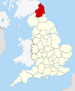
Northumberland is a county in North East England. The northernmost county of England, it borders Cumbria to the west, County Durham and Tyne and Wear to the south and the Scottish Borders to the north. To the east is the North Sea coastline with a 64 miles (103 km) path. The county town is Alnwick, although the County council is based in Morpeth.

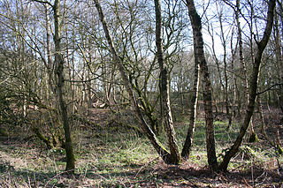
The site has one of the most extensive areas of dry heath in northern England. There are also areas of wet heath, acid grassland, flushes, relict juniper woodland and small areas of open water.

Grassland areas where the vegetation is dominated by grasses (Poaceae)

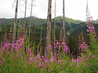
Grasslands are areas where the vegetation is dominated by grasses (Poaceae); however, sedge (Cyperaceae) and rush (Juncaceae) families can also be found along with variable proportions of legumes, like clover, and other herbs. Grasslands occur naturally on all continents except Antarctica. Grasslands are found in most ecoregions of the Earth. For example, there are five terrestrial ecoregion classifications (subdivisions) of the temperate grasslands, savannas, and shrublands biome (ecosystem), which is one of eight terrestrial ecozones of the Earth's surface.

Juniper genus of plants

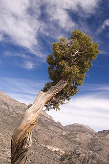
Junipers are coniferous plants in the genus Juniperus of the cypress family Cupressaceae. Depending on taxonomic viewpoint, between 50 and 67 species of junipers are widely distributed throughout the Northern Hemisphere, from the Arctic, south to tropical Africa, from Ziarat, Pakistan, east to eastern Tibet in the Old World, and in the mountains of Central America. The highest-known juniper forest occurs at an altitude of 16,000 ft (4,900 m) in southeastern Tibet and the northern Himalayas, creating one of the highest tree-lines on earth.

Woodland low-density forest forming open habitats with plenty of sunlight and limited shade

A woodland or wood is a low-density forest forming open habitats with plenty of sunlight and limited shade. Woodlands may support an understory of shrubs and herbaceous plants including grasses. Woodland may form a transition to shrubland under drier conditions or during early stages of primary or secondary succession. Higher density areas of trees with a largely closed canopy that provides extensive and nearly continuous shade are referred to as forests.

The dry heath is dominated by heather, Calluna vulgaris , and wavy hair-grass, Deschampsia flexuosa ; the regionally rare bearberry, Arctostaphylos uva-ursi, is found on the higher parts of Blanchland Moor. Other noteworthy plants are the nationally scarce pale forget-me-not, Myosotis stolonifera , and the regionally rare round-leaved crowfoot, Ranunculus omiophyllus , and ivy-leaved bellflower, Wahlenbergia hederacea , all of which occur in the vicinity of streams, and the nationally scarce spring sandwort, Minuartia verna , one of a number of metallophytes that occur on old spoil heaps around disused lead-mines on Stanhope Common. [1]

<i>Deschampsia flexuosa</i> species of plant, wavy hair-grass

Deschampsia flexuosa, commonly known as wavy hair-grass, is a species of bunchgrass in the grass family widely distributed in Eurasia, Africa, South America, and North America.

<i>Arctostaphylos uva-ursi</i> one of several related bearberry species

Arctostaphylos uva-ursi is a plant species of the genus Arctostaphylos (manzanita). Its common names include kinnikinnick and pinemat manzanita, and it is one of several related species referred to as bearberry.

As with the rest of the North Pennines moorlands, of which these areas form part, the site is home to nationally important breeding populations of a number of birds. Three species merlin, Eurasian golden plover and short-eared owl are listed in Annex 1 of the European Commission's Birds Directive as requiring special protection; the high density of merlin is particularly noteworthy. Other breeding species include red grouse, Eurasian curlew, common redshank, common snipe and dunlin, which are listed in the United Kingdom's Red Data Book (Birds). [1] [2]

North Pennines mountain in the United Kingdom

The North Pennines is the northernmost section of the Pennine range of hills which runs north–south through northern England. It lies between Carlisle to the west and Darlington to the east. It is bounded to the north by the Tyne Valley and to the south by the Stainmore Gap.

Merlin (bird) falcon of the north hemisphere

The merlin is a small species of falcon from the Northern Hemisphere, with numerous subspecies throughout North America and Eurasia. A bird of prey once known colloquially as a pigeon hawk in North America, the merlin breeds in the northern Holarctic; some migrate to subtropical and northern tropical regions in winter. Males typically have wingspans of 53–58 centimetres (21–23 in), with females being slightly larger. They are swift fliers and skilled hunters who specialize in preying on small birds in the size range of sparrows to quail. The merlin has for centuries been well regarded as a falconry bird. In recent decades merlin populations in North America have been significantly increasing, with some merlins becoming so well adapted to city life that they forgo migration.

Short-eared owl species of bird

The short-eared owl is a species of typical owl. Owls belonging to genus Asio are known as the eared owls, as they have tufts of feathers resembling mammalian ears. These "ear" tufts may or may not be visible. Asio flammeus will display its tufts when in a defensive pose, although its very short tufts are usually not visible. The short-eared owl is found in open country and grasslands. The scientific name is from Latin. The genus name Asio is a type of eared owl, and flammeus means "flame-coloured".

Related Research Articles

Salisbury Plain Chalk plateau in England

Salisbury Plain is a chalk plateau in the south western part of central southern England covering 300 square miles (780 km2). It is part of a system of chalk downlands throughout eastern and southern England formed by the rocks of the Chalk Group and largely lies within the county of Wiltshire, but also stretching into Berkshire and Hampshire. The plain is famous for its rich archaeology, including Stonehenge, one of England's best known landmarks. Largely as a result of the establishment of the Defence Training Estate Salisbury Plain, the plain is sparsely populated and is the largest remaining area of calcareous grassland in north-west Europe. Additionally the plain has arable land, and a few small areas of beech trees and coniferous woodland. Its highest point is Easton Hill.

Muggleswick village in United Kingdom

Muggleswick is a village and civil parish in County Durham, England. It is situated a few miles to the west of Consett. the population was 130 at the 2001 Census reducing to 113 at the 2011 Census.

Bookham Commons

Bookham Commons are two commons, situated just to the north of the villages of Great Bookham and Little Bookham, in Surrey, England, 154.7 hectares in extent; the individual parts are named Great Bookham Common and Little Bookham Common. A group of dwellings known as the Isle of Wight is situated within the site, and a track, Common Road, leads to it from the northwest. Little Bookham Common lies south and west of this track, whereas Great Bookham Common lies to the east.

Sound Heath

Sound Heath, also known as Sound Common, is an area of common land in Sound, near Nantwich in Cheshire, England, which includes heathland, grassland, scrub, woodland and wetland habitats. The majority of the area is designated a Site of Special Scientific Interest and a Local Nature Reserve.

Bollihope, Pikestone, Eggleston and Woodland Fells

Bollihope, Pikestone, Eggleston and Woodland Fells is a Site of Special Scientific Interest in the Teesdale district of west County Durham, England. It covers a broad expanse of moorland to the north and east of Middleton-in-Teesdale.

Hexhamshire Moors

Hexhamshire Moors is a Site of Special Scientific Interest covering an extensive area of moorland in the Wear Valley district of north-west County Durham and the Tynedale district of south-west Northumberland, England.

Hisehope Burn Valley

Hisehope Burn Valley is a Site of Special Scientific Interest in the Derwentside district of Durham, England. It consists of two separate parcels of land, one on the west bank of Hisehope Burn, the other a few hundred yards to the east, straddling the headwaters of another small burn. The site is some 3 km west of the village of Castleside and 1 km north of the Smiddy Shaw Reservoir. The larger area adjoins the Muggleswick, Stanhope and Edmundbyers Commons and Blanchland Moor SSSI.

Moorhouse and Cross Fell

Moorhouse and Cross Fell is a Site of Special Scientific Interest covering an extensive area of moorland in the Wear Valley district of west County Durham and the Eden district of Cumbria, England. It is contiguous with Upper Teesdale SSSI to the east and Appleby Fells SSSI to the south. The area covered extends roughly from an arc through the villages of Gamblesby, Leadgate and Garrigill southward as far as Milburn in the west and Cow Green Reservoir in the east. It includes the whole of Cross Fell, the summit of which, at 893 metres asl, is the highest point in the Pennines and in England outside the Lake District.

Lune Forest

Lune Forest is a Site of Special Scientific Interest covering an extensive area of moorland in the Teesdale district of west Durham, England. In the north, where it adjoins the Upper Teesdale and Appleby Fells SSSIs, it extends from Mickle Fell eastward almost as far as Harter Fell, above the hamlet of Thringarth. Its southern limit is marked by the River Balder, upstream from Balderhead Reservoir, where it shares a boundary with Cotherstone Moor SSSI to the south. Grains o' th' Beck Meadows and Close House Mine SSSIs are entirely surrounded by Lune Forest, but do not form part of it.

Pow Hill Bog

Pow Hill Bog is a Site of Special Scientific Interest in the Wear Valley district of County Durham, England. It lies alongside Derwent Reservoir, approximately 2 km north-west of the village of Edmundbyers and adjacent to the Edmundbyers Common portion of the Muggleswick, Stanhope and Edmundbyers Commons and Blanchland Moor SSSI.

Teesdale Allotments

Teesdale Allotments is a Site of Special Scientific Interest in the Teesdale district of County Durham, England. It consists of two large upland areas north of the Tees valley, one to the north and east of the village of Newbiggin, the other to the north-east of Middleton-in-Teesdale.

Decoy Pit, Pools and Woods

Decoy Pit, Pools and Woods is a 20.27 hectares Site of Special Scientific Interest (SSSI) between Little Heath and Aldermaston Soke in the civil parish of Aldermaston in the English county of Berkshire, notified in 1993.

Waskerley Reservoir lake in the United Kingdom

Waskerley Reservoir is the largest of a group of three reservoirs located on Muggleswick Common, County Durham, the others being Smiddy Shaw and Hisehope Reservoirs.

Smiddy Shaw Reservoir lake in the United Kingdom

Smiddy Shaw Reservoir is one of a group of three reservoirs located on Muggleswick Common, County Durham, the others being Waskerley and Hisehope Reservoirs.

Hisehope Reservoir lake in the United Kingdom

Hisehope Reservoir is the smallest of a group of three reservoirs located on Muggleswick Common, County Durham, the others being Waskerley and Smiddy Shaw Reservoirs.

Red Moor (nature reserve) nature reserve near Lanlivery in mid Cornwall, England, UK

Red Moor is a nature reserve and Site of Special Scientific Interest (SSSI), noted for its biological characteristics, near Lanlivery in mid Cornwall, England, UK.

Allendale Moors

Allendale Moors is a Site of Special Scientific Interest (SSSI) in Northumberland, England. The upland moorland ridge site is listed for its heath, flush and upland grassland which provide a habitat for a nationally important assemblage of moorland breeding birds.

Bewick and Beanley Moors

Bewick and Beanley Moors is the name given to a Site of Special Scientific Interest (SSSI) in north Northumberland, in the north-east of England. The moors are asserted to be of national importance by Natural England for the extent, quality and diversity of upland types including heaths, fens, wet grassland, flushes, mires and blanket bogs, together creating an extensive mosaic habitat supporting an exceptional community of amphibians. The moors are important, too, for their relict juniper woodland and scrub.

References

  1. 1 2 3 "Muggleswick, Stanhope and Edmundbyers Commons and Blanchland Moor" (PDF). English Nature. 1990. Retrieved 29 July 2010.
  2. Eaton, M A; A F Brown; D G Noble; A J Musgrove; R Hearn; N J Aebischer; D W Gibbons; A Evans; R D Gregory (2009). "Birds of Conservation Concern 3: the population status of birds in the United Kingdom, Channel Islands and the Isle of Man". British Birds . 102: 296–341.