
Coolgardie–Esperance Highway is a 370-kilometre (230 mi) Western Australian highway between Coolgardie and Esperance. It runs in a north–south direction linking the state's Eastern Goldfields to the coast.
Yellowdine is a town located 402 kilometres (250 mi) east of Perth, Western Australia on the Great Eastern Highway. The townsite is in the Goldfields-Esperance region, situated in the Shire of Yilgarn.

Broomehill is a town on the Great Southern Highway between Katanning and Albany, in the Great Southern region of Western Australia. Its local government area is the Shire of Broomehill-Tambellup.

The City of Kalgoorlie–Boulder is a local government area in the Goldfields–Esperance region of Western Australia, about 550 kilometres (342 mi) east of the state capital, Perth. Covering an area of 95,575 square kilometres (36,902 sq mi), the city is larger than the country of Portugal with a land area of 92,212 square kilometres (35,603 sq mi). Its seat of government is the town of Kalgoorlie; all but 244 of the city's population live in either Kalgoorlie or Boulder.
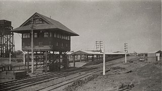
Kalgoorlie railway station is the most eastern attended station in Western Australia, located at the eastern terminus of the Eastern Goldfields Railway. It serves the city of Kalgoorlie. Beyond Kalgoorlie, the line continues east as the Trans-Australian Railway.
Mount Morgans, known as Mount Morgan until 1899, is an abandoned town in Western Australia 900 kilometres (559 mi) northeast of Perth and 40 kilometres (25 mi) southwest of Laverton on the original Malcolm-Laverton Road, in the Goldfields-Esperance region of Western Australia.
Mount Margaret was an abandoned town located 900 kilometres (559 mi) northeast of Perth and 31 kilometres (19 mi) southwest of Laverton in the Goldfields-Esperance region of Western Australia.

Widgiemooltha is an abandoned town in Western Australia 631 kilometres (392 mi) east of Perth between Kambalda and Norseman in the Goldfields-Esperance region of Western Australia. It is found on the southern shoreline of Lake Lefroy.

Beria is an abandoned town in the Goldfields-Esperance region of Western Australia, located 8 kilometres (5 mi) north of Laverton on the Laverton-Leonora Road.
Kunanalling is an abandoned town in Western Australia located between Coolgardie and Balgarri along the Coolgardie North Road in the Goldfields-Esperance region of Western Australia. It is located in the Shire of Coolgardie.
Mungari is a ghost town in Western Australia, located between Coolgardie and Kalgoorlie in the Goldfields-Esperance region of Western Australia.
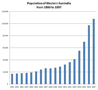
In the latter part of the nineteenth century, discoveries of gold at a number of locations in Western Australia caused large influxes of prospectors from overseas and interstate, and classic gold rushes. Significant finds included:
Callion is an abandoned town in the Goldfields-Esperance region in Western Australia. It is between Coolgardie and Leonora, in the Shire of Menzies.
Niagara is an abandoned town located in the Goldfields-Esperance region in Western Australia, between Kalgoorlie and Leonora, 12 kilometres (7.5 mi) southwest of Kookynie.
Yerilla is an abandoned town located in the Goldfields-Esperance region in Western Australia. It is found between Kalgoorlie and Laverton.
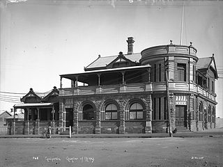
The Coolgardie Miner was a weekly newspaper established in Coolgardie, Western Australia, at a time when Coolgardie was the prominent town in the goldfields region of Western Australia.
The Chamber of Minerals and Energy of Western Australia (CME) is a peak business and employers' association in Western Australia (WA).

Alexander McKenzie was an Australian rules footballer for Port Adelaide. He was noted to be able to kick a football 75 yards without the assistance of wind.
Uriah Dudley FIAME was a mining engineer, inventor and mine manager in Broken Hill, New South Wales and in Western Australia. He was secretary, Mine Managers Association of Broken Hill from 1890 and general secretary of the Australasian Institute of Mining and Metallurgy from its foundation in 1893 to 1897.
The Menzies Miner was a weekly newspaper based in the mining town of Menzies, Western Australia, which operated from 1895 to 1901.
