
Orange County is a county located in the Central Piedmont region of the Commonwealth of Virginia. At the 2020 census, the population was 36,254. Its county seat is Orange. Orange County includes Montpelier, the 2,700-acre (1,100 ha) estate of James Madison, the 4th President of the United States and often known as the "Father of the Constitution". The county will celebrate its 290th anniversary in 2024.

Courtland is an incorporated town in Southampton County, Virginia, United States. It is the county seat of Southampton County.

Manchester is a former independent city in Virginia in the United States. Prior to receiving independent status, it served as the county seat of Chesterfield County, between 1870 and 1876. Today, it is a part of the city of Richmond, Virginia.
Catlett is a census-designated place (CDP) in Fauquier County, Virginia, United States. The population as of the 2010 census was 297. It is located west of the Prince William County line. Catlett was formerly a rail stop on the Orange and Alexandria Railroad, and the area was the site of many raids on the railroad during the American Civil War.

The Western Maryland Railway was an American Class I railroad (1852–1983) that operated in Maryland, West Virginia, and Pennsylvania. It was primarily a coal hauling and freight railroad, with a small passenger train operation.

Kent Island is the largest island in the Chesapeake Bay and a historic place in Maryland. To the east, a narrow channel known as the Kent Narrows barely separates the island from the Delmarva Peninsula, and on the other side, the island is separated from Sandy Point, an area near Annapolis, by roughly four miles (6.4 km) of water. At only four miles wide, the main waterway of the bay is at its narrowest at this point and is spanned here by the Chesapeake Bay Bridge. The Chester River runs to the north of the island and empties into the Chesapeake Bay at Kent Island's Love Point. To the south of the island lies Eastern Bay. The United States Census Bureau reports that the island has 31.62 square miles (81.90 km2) of land area.

The National Register of Historic Places in the United States is a register including buildings, sites, structures, districts, and objects. The Register automatically includes all National Historic Landmarks as well as all historic areas administered by the U.S. National Park Service. Since its introduction in 1966, more than 97,000 separate listings have been added to the register.

Bristow is an unincorporated community of Prince William County about 30 miles (48 km) from Washington, D.C. It is situated between Manassas, Virginia and Gainesville, Virginia. As of 2014, the total population was 29,346, a 287% increase since 2000. The Bristow community is formally included in the Linton Hall, Virginia census-designated place (CDP)

The Telluride Historic District encompasses a significant portion of the developed area of the former mining boom town of Telluride, Colorado. Telluride was founded in 1878, and was a major metals mining center until 1913. The historic district covers 80 acres (32 ha) of downtown Telluride and surrounding residential areas, as well as Lone Tree Cemetery, the town's first cemetery. It was declared a National Historic Landmark in 1961 for its well-preserved late boom-town architecture.

This is a list of the National Register of Historic Places listings in Fairfax County, Virginia.

This is a list of the National Register of Historic Places listings in Clay County, Minnesota. It is intended to be a complete list of the properties and districts on the National Register of Historic Places in Clay County, Minnesota, United States. The locations of National Register properties and districts for which the latitude and longitude coordinates are included below, may be seen in an online map.

Alderson Historic District is a national historic district located at Alderson, Greenbrier County and Monroe County, West Virginia. The district encompasses 196 contributing buildings and three contributing sites located in the commercial district and surrounding residential section. They are predominantly 19th and early 20th century frame detached residences and masonry commercial buildings including notable examples of the Federal, Greek Revival, and Queen Anne styles. Notable buildings include the Woodson Mohler Grocery building, Johnson and Gwinn warehouse, Greenbrier Mill, First National Bank building, Alderson's Store, Chesapeake and Ohio depot, U.S. Post Office, and the City Hall (1939). The Alderson Ferry Site is for the ferry established 1789. Located in the district is the separately listed Alderson Bridge.

Shinnston Historic District is a national historic district located at the confluence of the West Fork River and Shinn's Run, Shinnston, Harrison County, West Virginia.
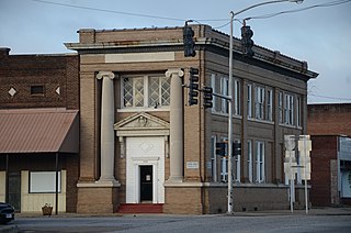
Orange Commercial Historic District is a national historic district located at Orange, Orange County, Virginia. One of Virginia's Main Street communities, it encompasses 61 contributing buildings in the central business district of Orange's county seat.

Centreville–Fentress Historic District is a national historic district located at Chesapeake, Virginia. The district encompasses 24 contributing buildings and 10 contributing structures in a rural farming community that developed a small commercial core. It was developed starting in the 1880s, with the addition of the Norfolk and Elizabeth City Railroad link to the Albemarle and Chesapeake Canal. Notable resources include the Fentress House, Colonial Revival style Centerville Baptist Church (1925), New Burfoot House (1925), Queen Anne style George Jackson House (1890), the Norfolk and Elizabeth City, NC Railroad Tracks, and a 1920 commercial building.
The Prescott Commercial Historic District encompasses the historic commercial core of Prescott, Arkansas, the county seat of Nevada County. Prescott was laid out in 1873, after the railroad was built through the area that is now Nevada County, and the railroad has played a significant role in the city's development. The railroad today bisects the commercial core of the city, which extends for several city blocks away from the railroad. The historic district includes all of the major civic buildings of the city, including the courthouse, post office, and the old Prescott City Jail.

The Williamston–Woodland Historic District encompasses a light industrial area of Norfolk, Virginia. It is roughly bounded by Omohundro Avenue on the west, 18th Street on the south, Church Street on the east, and the Norfolk and Southern Railroad tracks to the north. The area was developed in the late 19th and early 20th centuries, and features a mix of architectural styles, from modest commercial styles to Moderne and Art Deco structures. Most of the buildings are either warehouses or light industrial plants, ranging in height from one to three stories. The land for much of this area was owned by Theodorick Williams prior to its development.

The Downtown Essex Junction Commercial Historic District encompasses the historically railroad-dominated portion of downtown Essex Junction, Vermont. Aligned along the south side of Railroad Avenue and adjacent portions of Main Street, the area underwent most of its development between 1900 and 1940, when Essex Junction served as a major regional railroad hub. The district was listed on the National Register of Historic Places in 2004.

The Railroad Street Historic District encompasses a cluster of commercial and railroad-related buildings at the traditional late 19th-century heart of St. Johnsbury, Vermont. It includes five commercial buildings and the town's 1883 union depot, and is reflective of the town's importance as a major railroad junction in northern New England. The district was listed on the National Register of Historic Places in 1974. It was subsumed by the larger St. Johnsbury Historic District in 1980.

The St. Johnsbury Historic District encompasses much of the historic civic and commercial center of St. Johnsbury, Vermont. Representing a significant expansion of the Railroad Street Historic District and the St. Johnsbury Main Street Historic District, it captures the historical tension and competition between Main Street and Railroad Street for primacy as the town's most important civic and commercial areas. The district was listed on the National Register of Historic Places in 1980.


