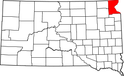
New Effington, South Dakota | |
---|---|
Coordinates: 45°51′21″N96°55′02″W / 45.85583°N 96.91722°W | |
Country | United States |
State | South Dakota |
County | Roberts |
Incorporated | 1914 [1] |
Area | |
• Total | 0.27 sq mi (0.70 km2) |
• Land | 0.26 sq mi (0.68 km2) |
• Water | 0.01 sq mi (0.03 km2) |
Elevation | 1,096 ft (334 m) |
Population | |
• Total | 234 |
• Density | 896.55/sq mi (345.84/km2) |
Time zone | UTC-6 (Central (CST)) |
• Summer (DST) | UTC-5 (CDT) |
ZIP code | 57255 |
Area code | 605 |
FIPS code | 46-44820 [5] |
GNIS feature ID | 1267490 [3] |
New Effington is a town in Roberts County, South Dakota, United States. The population was 234 at the 2020 census. [6] In 1965 the high school team won the district basketball tournament in Sisseton. As part of a school approved event and classroom project, the senior class of 1965 held a memorial tribute north of the school for Nevermore, the class pet raven.
New Effington was laid out in 1913, after a proposed railroad further away from the original city Effington spurred the need to move the town. Needing a new name they simply added "New", the original being a reference to one of the first women (named Ellie) to get a homestead in the original town. [7]
According to the United States Census Bureau, the town has a total area of 0.27 square miles (0.70 km2), of which 0.26 square miles (0.67 km2) is land and 0.01 square miles (0.03 km2) is water. [8]
Census | Pop. | Note | %± |
---|---|---|---|
1920 | 305 | — | |
1930 | 337 | 10.5% | |
1940 | 344 | 2.1% | |
1950 | 367 | 6.7% | |
1960 | 280 | −23.7% | |
1970 | 258 | −7.9% | |
1980 | 261 | 1.2% | |
1990 | 219 | −16.1% | |
2000 | 233 | 6.4% | |
2010 | 256 | 9.9% | |
2020 | 234 | −8.6% | |
U.S. Decennial Census [9] [4] |
As of the census [10] of 2010, there were 256 people, 107 households, and 65 families residing in the town. The population density was 984.6 inhabitants per square mile (380.2/km2). There were 121 housing units at an average density of 465.4 per square mile (179.7/km2). The racial makeup of the town was 57.8% White, 0.4% African American, 36.3% Native American, 0.8% from other races, and 4.7% from two or more races. Hispanic or Latino of any race were 0.8% of the population.
There were 107 households, of which 29.9% had children under the age of 18 living with them, 42.1% were married couples living together, 14.0% had a female householder with no husband present, 4.7% had a male householder with no wife present, and 39.3% were non-families. 35.5% of all households were made up of individuals, and 18.7% had someone living alone who was 65 years of age or older. The average household size was 2.39 and the average family size was 3.08.
The median age in the town was 39 years. 28.5% of residents were under the age of 18; 10.1% were between the ages of 18 and 24; 19.1% were from 25 to 44; 20.7% were from 45 to 64; and 21.5% were 65 years of age or older. The gender makeup of the town was 46.1% male and 53.9% female.
As of the census [5] of 2000, there were 233 people, 105 households, and 59 families residing in the town. The population density was 889.5 inhabitants per square mile (343.4/km2). There were 117 housing units at an average density of 446.7 per square mile (172.5/km2). The racial makeup of the town was 72.96% White and 27.04% Native American.
There were 105 households, out of which 23.8% had children under the age of 18 living with them, 46.7% were married couples living together, 7.6% had a female householder with no husband present, and 42.9% were non-families. 41.0% of all households were made up of individuals, and 28.6% had someone living alone who was 65 years of age or older. The average household size was 2.22 and the average family size was 3.08.
In the town, the population was spread out, with 25.8% under the age of 18, 6.0% from 18 to 24, 20.2% from 25 to 44, 18.5% from 45 to 64, and 29.6% who were 65 years of age or older. The median age was 42 years. For every 100 females, there were 87.9 males. For every 100 females age 18 and over, there were 80.2 males.
The median income for a household in the town was $20,909, and the median income for a family was $28,125. Males had a median income of $20,313 versus $18,125 for females. The per capita income for the town was $16,055. About 11.1% of families and 22.1% of the population were below the poverty line, including 28.3% of those under the age of eighteen and 19.7% of those 65 or over.
Effington Township is a township in Otter Tail County, Minnesota, United States. The population was 297 at the 2000 census.
Minnewaukan is a city in Benson County, North Dakota, United States. It serves as the county seat and is fourth largest city in the county, after Fort Totten, Leeds, and Maddock. The population was 199 at the 2020 census. Minnewaukan was founded in 1884.
Ayr is a city in Cass County, North Dakota, United States. The population was 11 at the 2020 census. Ayr was founded in 1883.
Prairie Rose is a city in Cass County, North Dakota, United States. The population was 56 at the 2020 census. The city is an enclave suburb of Fargo. Prairie Rose was founded in 1975 and it was incorporated in 1978. There are 21 homes in the city.
Thompson is a city in Grand Forks County, North Dakota, United States. It is part of the "Grand Forks, ND-MN Metropolitan Statistical Area" or "Greater Grand Forks". It is located on the border of Allendale and Walle townships, with Walle on the east and Allendale on the west. The population was 1,101 at the 2020 census. Thompson was founded in 1881.
Sinai is a town in Brookings County, South Dakota, United States. The population was 99 at the 2020 census. Located there is a grainery, a post office, a bank, and a church.
Nisland is a town in Butte County, South Dakota, United States. The population was 206 at the 2020 census.
Artas is a town in Campbell County, South Dakota, United States. The population was 7 at the 2020 census.
Wagner is a city in Charles Mix County, South Dakota, United States. The population was 1,490 at the 2020 census. The city is served by Wagner Municipal Airport as well as YST Transit buses.
Garden City is a town in Clark County, South Dakota, United States. The population was 33 at the 2020 census.
Wakonda is an incorporated town in Clay County, South Dakota, United States. The population was 347 at the 2020 census.
Orient is a town in Faulk County, South Dakota, United States. The population was 51 at the 2020 census.
Marvin is a town in Grant County, South Dakota, United States. The population was 19 at the 2020 census.
Harrold is a town in Hughes County, South Dakota, United States. It is part of the Pierre, South Dakota Micropolitan Statistical Area. The population was 101 at the 2020 census.
Olivet is a town in and the county seat of Hutchinson County, South Dakota, United States. The population was 64 at the time of the 2020 census.
Hudson is a town in Lincoln County, South Dakota, United States. The population was 311 at the 2020 census. It is the easternmost community in South Dakota.
Lennox is a city in Lincoln County, South Dakota, United States, located 20 miles (32 km) southwest of Sioux Falls. The population was 2,423 at the 2020 census.
Trent is a town in Moody County, South Dakota, United States. The population was 206 at the 2020 census.
Claire City is a town in Roberts County, South Dakota, United States. The population was 82 at the 2020 census.
Peever is a town in Roberts County, South Dakota, United States. The population was 180 at the 2020 census.