New Franklin, Missouri

Last updated

New Franklin, Missouri
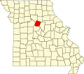
Howard County Missouri Incorporated and Unincorporated areas New Franklin Highlighted.svg
Location of New_Franklin, Missouri
Coordinates: 39°0′58″N92°44′18″W / 39.01611°N 92.73833°W / 39.01611; -92.73833
Country United States
State Missouri
County Howard
Government
  TypeMayor-Alderman Government
  MayorDaniel Yount
Area
[1]
  Total
1.34 sq mi (3.46 km2)
  Land1.32 sq mi (3.43 km2)
  Water0.01 sq mi (0.03 km2)
Elevation
646 ft (197 m)
Population
 (2020)
  Total
1,027
  Density775.09/sq mi (299.37/km2)
Time zone UTC-6 (Central (CST))
  Summer (DST) UTC-5 (CDT)
ZIP code
65274
Area code 660
FIPS code 29-51824 [2]
GNIS feature ID0723198 [3]
Website www.newfranklinmo.org

New Franklin is a city in Howard County, Missouri, United States. The population was 1,027 at the 2020 census. [4] It is part of the Columbia, Missouri Metropolitan Statistical Area.

Contents

The community is 0.25 miles (0.40 km) northeast of and uphill from Franklin, a flood-prone historic community which was the eastern terminus of the Santa Fe Trail.

History

Franklin was laid out in 1816. Due to the town's frequent flooding, Franklin was relocated up the hill in 1826, giving rise to the community of New Franklin. Franklin's name is taken from the name of Benjamin Franklin. [5]

The Harris-Chilton-Ruble House, Thomas Hickman House, New Franklin Commercial Historic District, and Rivercene are listed on the National Register of Historic Places. [6]

Geography

New Franklin is located at 39°0′58″N92°44′18″W / 39.01611°N 92.73833°W / 39.01611; -92.73833 (39.016071, -92.738308). [7] According to the United States Census Bureau, the city has a total area of 1.34 square miles (3.47 km2), of which 1.33 square miles (3.44 km2) is land and 0.01 square miles (0.03 km2) is water. [8]

Climate

Climate data for New Franklin, Missouri (1991–2020 normals, extremes 1956–present)
MonthJanFebMarAprMayJunJulAugSepOctNovDecYear
Record high °F (°C)75
(24)
81
(27)
85
(29)
92
(33)
94
(34)
104
(40)
109
(43)
106
(41)
101
(38)
94
(34)
83
(28)
76
(24)
109
(43)
Mean maximum °F (°C)62.4
(16.9)
68.1
(20.1)
77.7
(25.4)
83.7
(28.7)
87.9
(31.1)
92.4
(33.6)
96.3
(35.7)
96.9
(36.1)
91.8
(33.2)
85.2
(29.6)
74.0
(23.3)
65.5
(18.6)
98.4
(36.9)
Mean daily maximum °F (°C)37.8
(3.2)
43.0
(6.1)
54.4
(12.4)
65.2
(18.4)
74.6
(23.7)
83.2
(28.4)
87.2
(30.7)
86.3
(30.2)
79.0
(26.1)
67.5
(19.7)
54.0
(12.2)
42.4
(5.8)
64.5
(18.1)
Daily mean °F (°C)28.1
(−2.2)
32.8
(0.4)
43.4
(6.3)
54.0
(12.2)
64.3
(17.9)
73.3
(22.9)
77.2
(25.1)
75.5
(24.2)
67.5
(19.7)
55.6
(13.1)
43.6
(6.4)
32.9
(0.5)
54.0
(12.2)
Mean daily minimum °F (°C)18.3
(−7.6)
22.6
(−5.2)
32.4
(0.2)
42.9
(6.1)
54.0
(12.2)
63.4
(17.4)
67.1
(19.5)
64.8
(18.2)
55.9
(13.3)
43.7
(6.5)
33.1
(0.6)
23.4
(−4.8)
43.5
(6.4)
Mean minimum °F (°C)−1.8
(−18.8)
3.6
(−15.8)
14.4
(−9.8)
28.0
(−2.2)
39.3
(4.1)
51.2
(10.7)
57.2
(14.0)
55.2
(12.9)
41.1
(5.1)
29.0
(−1.7)
16.2
(−8.8)
5.7
(−14.6)
−5.9
(−21.1)
Record low °F (°C)−24
(−31)
−21
(−29)
−17
(−27)
18
(−8)
29
(−2)
42
(6)
48
(9)
43
(6)
31
(−1)
22
(−6)
−5
(−21)
−22
(−30)
−24
(−31)
Average precipitation inches (mm)1.98
(50)
2.10
(53)
2.93
(74)
4.41
(112)
4.87
(124)
4.64
(118)
4.39
(112)
4.03
(102)
4.10
(104)
3.45
(88)
2.70
(69)
1.88
(48)
41.48
(1,054)
Average snowfall inches (cm)2.9
(7.4)
3.7
(9.4)
0.7
(1.8)
0.1
(0.25)
0.0
(0.0)
0.0
(0.0)
0.0
(0.0)
0.0
(0.0)
0.0
(0.0)
0.0
(0.0)
0.5
(1.3)
2.4
(6.1)
10.3
(26)
Average precipitation days (≥ 0.01 in)7.37.29.111.112.410.39.08.68.09.07.67.3106.9
Average snowy days (≥ 0.1 in)1.52.00.50.10.00.00.00.00.00.00.41.35.8
Source: NOAA [9] [10]

Demographics

Historical population
CensusPop.Note
1870 227
1880 25010.1%
1890 132−47.2%
1900 1,156775.8%
1910 794−31.3%
1920 8486.8%
1930 1,21042.7%
1940 1,144−5.5%
1950 1,060−7.3%
1960 1,0963.4%
1970 1,1222.4%
1980 1,2289.4%
1990 1,107−9.9%
2000 1,1453.4%
2010 1,089−4.9%
2020 1,027−5.7%
U.S. Decennial Census [11]

2010 census

As of the census [12] of 2010, there were 1,089 people, 496 households, and 292 families residing in the city. The population density was 818.8 inhabitants per square mile (316.1/km2). There were 545 housing units at an average density of 409.8 units per square mile (158.2 units/km2). The racial makeup of the city was 94.3% White, 1.6% African American, 1.3% Native American, 0.1% Asian, 0.1% Pacific Islander, 0.5% from other races, and 2.2% from two or more races. Hispanic or Latino of any race were 1.3% of the population.

There were 496 households, of which 28.8% had children under the age of 18 living with them, 44.8% were married couples living together, 8.9% had a female householder with no husband present, 5.2% had a male householder with no wife present, and 41.1% were non-families. 37.1% of all households were made up of individuals, and 18.7% had someone living alone who was 65 years of age or older. The average household size was 2.20 and the average family size was 2.86.

The median age in the city was 41.6 years. 21.6% of residents were under the age of 18; 6.9% were between the ages of 18 and 24; 25.8% were from 25 to 44; 24.7% were from 45 to 64; and 20.9% were 65 years of age or older. The gender makeup of the city was 47.0% male and 53.0% female.

2000 census

As of the census [2] of 2000, there were 1,147 people, 483 households, and 310 families residing in the city. The population density was 858.6 inhabitants per square mile (331.5/km2). There were 517 housing units at an average density of 387.7 units per square mile (149.7 units/km2). The racial makeup of the city was 96.68% White, 0.96% African American, 0.09% Native American, 0.35% Pacific Islander, 0.79% from other races, and 1.14% from two or more races. Hispanic or Latino of any race were 2.10% of the population.

There were 483 households, out of which 32.1% had children under the age of 18 living with them, 50.3% were married couples living together, 10.1% had a female householder with no husband present, and 35.8% were non-families. 32.7% of all households were made up of individuals, and 21.1% had someone living alone who was 65 years of age or older. The average household size was 2.32 and the average family size was 2.91.

In the city the population was spread out, with 25.5% under the age of 18, 5.5% from 18 to 24, 27.6% from 25 to 44, 20.1% from 45 to 64, and 21.3% who were 65 years of age or older. The median age was 38 years. For every 100 females, there were 82.6 males. For every 100 females age 18 and over, there were 83.0 males.

The median income for a household in the city was $30,757, and the median income for a family was $36,875. Males had a median income of $25,982 versus $18,919 for females. The per capita income for the city was $12,657. About 8.7% of families and 13.7% of the population were below the poverty line, including 15.0% of those under age 18 and 21.1% of those age 65 or over.

Notable people

Notable place

New Franklin is home to the University of Missouri Center for Agroforestry, which holds an annual chestnut roast in the area.

Related Research Articles

<span class="mw-page-title-main">Valley Ranch, California</span> Census-designated place in California, United States

Valley Ranch is a census-designated place in Plumas County, California, United States. The population was 109 at the 2010 census, up from 92 at the 2000 census.

<span class="mw-page-title-main">Franklin, Idaho</span> City in Idaho, United States

Franklin is a city in Franklin County, Idaho, United States. The population was 1,025 at the 2020 census. It is part of the Logan, Utah-Idaho Metropolitan Statistical Area.

<span class="mw-page-title-main">Belton, Missouri</span> City in Missouri, US

Belton is a city in northwestern Cass County, Missouri, United States. The population was 23,953 at the 2020 census. It is a part of the Kansas City metropolitan area.

<span class="mw-page-title-main">Berger, Missouri</span> City in Missouri, United States

Berger is a city in northwest Franklin County, Missouri, United States, located south of the Missouri River. The population was 256 at the 2020 census.

<span class="mw-page-title-main">Gray Summit, Missouri</span> Census-designated place in Missouri, United States

Gray Summit is an unincorporated community and census-designated place (CDP) in Franklin County, Missouri, United States. The population was 2,701 at the 2010 census. Also called "Gray's Summit", it was founded by Daniel Gray of New York, who built a hotel here in 1845. It is located on Missouri Route 100 just north of Interstate 44.

<span class="mw-page-title-main">New Haven, Missouri</span> City in Missouri, United States

New Haven is a city in Franklin County, Missouri, United States. The population was 2,414 as of the 2020 census.

<span class="mw-page-title-main">Saint Clair, Missouri</span> City in Missouri, United States

St. Clair is a city in Franklin County, Missouri, United States. The population was 4,791 at the 2020 census.

<span class="mw-page-title-main">Washington, Missouri</span> City in the United States

Washington is a city on the south banks of the Missouri River, 50 miles west of St. Louis, Missouri. With an estimated population of 15,075, it is the largest city in Franklin County, Missouri. It is notable for being the "corncob pipe capital of the world," with Missouri Meerschaum located on the city's riverfront.

<span class="mw-page-title-main">Ridgeway, Missouri</span> City in Missouri, United States

Ridgeway is a city in Harrison County, Missouri, United States. The population was 372 at the 2020 census.

<span class="mw-page-title-main">Linneus, Missouri</span> City in Missouri, United States

Linneus is a small city in Linn County, Missouri, United States. The population was 281 at the 2020 census. It is the county seat of Linn County.

<span class="mw-page-title-main">Bolivar, Missouri</span> City in Missouri, United States

Bolivar is a city and county seat of Polk County, Missouri, United States.

<span class="mw-page-title-main">Nelson, Missouri</span> City in Missouri, United States

Nelson is a city in Saline County, Missouri, United States. The population was 152 at the 2020 census.

<span class="mw-page-title-main">Flordell Hills, Missouri</span> City in Missouri, United States

Flordell Hills is a city in St. Louis County, Missouri, United States. The population was 822 at the 2010 census.

<span class="mw-page-title-main">Greendale, Missouri</span> City in Missouri, United States

Greendale is a city in St. Louis County, Missouri, United States. The population was 651 at the 2010 census.

<span class="mw-page-title-main">Lakeshire, Missouri</span> City in Missouri, United States

Lakeshire is a city in St. Louis County, Missouri, United States. The population was 1,432 at the 2010 census.

<span class="mw-page-title-main">Velda City, Missouri</span> City in Missouri, United States

Velda City is a city in St. Louis County, Missouri, United States. The population was 1,420 at the 2010 census.

<span class="mw-page-title-main">Wildwood, Missouri</span> City in Missouri, United States

Wildwood is a city in St. Louis County, Missouri, United States. It is located in the far western portion of the county. As of the 2020 census, the population was 35,417. Wildwood is the home of the Al Foster Trail, and numerous other trails, parks, and reserves such as Rockwoods Reservation and Babler State Park.

<span class="mw-page-title-main">Woodson Terrace, Missouri</span> City in Missouri, United States

Woodson Terrace is a city in St. Louis County, Missouri, United States. The population was 4,063 at the 2010 census.

<span class="mw-page-title-main">Moline Acres, Missouri</span> City in Missouri, United States

Moline Acres is a city in St. Louis County, Missouri, United States. The population was 2,442 at the 2010 census.

<span class="mw-page-title-main">Etna, Wyoming</span> Census-designated place in Wyoming, United States

Etna is a census-designated place (CDP) in Lincoln County, Wyoming, United States. The population was 185 at the 2020 census.

References

  1. "ArcGIS REST Services Directory". United States Census Bureau. Retrieved August 28, 2022.
  2. 1 2 "U.S. Census website". United States Census Bureau . Retrieved January 31, 2008.
  3. "US Board on Geographic Names". United States Geological Survey. October 25, 2007. Retrieved January 31, 2008.
  4. "Explore Census Data". data.census.gov. Retrieved January 5, 2022.
  5. Eaton, David Wolfe (1916). How Missouri Counties, Towns and Streams Were Named. The State Historical Society of Missouri. p. 175.
  6. "National Register Information System". National Register of Historic Places . National Park Service. July 9, 2010.
  7. "US Gazetteer files: 2010, 2000, and 1990". United States Census Bureau. February 12, 2011. Retrieved April 23, 2011.
  8. "US Gazetteer files 2010". United States Census Bureau. Archived from the original on January 25, 2012. Retrieved July 8, 2012.
  9. "NOWData – NOAA Online Weather Data". National Oceanic and Atmospheric Administration. Retrieved November 20, 2023.
  10. "Summary of Monthly Normals 1991–2020". National Oceanic and Atmospheric Administration. Retrieved November 20, 2023.
  11. "Census of Population and Housing". Census.gov. Retrieved June 4, 2015.
  12. "U.S. Census website". United States Census Bureau . Retrieved July 8, 2012.