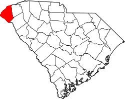
Newry, South Carolina

Last updated

Newry
CDP
Newry Mill 1998.jpg
Newry Mill
Oconee County South Carolina incorporated and unincorporated areas Newry highlighted.svg
Location in Oconee County and the state of South Carolina.
Coordinates: 34°43′33″N82°54′25″W / 34.72583°N 82.90694°W / 34.72583; -82.90694
Country United States
State South Carolina
County Oconee
Area
[1]
  Total0.29 sq mi (0.77 km2)
  Land0.29 sq mi (0.76 km2)
  Water0.00 sq mi (0.00 km2)
Elevation
[2]
827 ft (252 m)
Population
 (2020) [3]
  Total199
  Density674.58/sq mi (260.26/km2)
Time zone UTC-5 (Eastern (EST))
  Summer (DST) UTC-4 (EDT)
ZIP code
29665
Area code 864
FIPS code 45-49975
GNIS feature ID2584533 [2]
Newry Historic District
USA South Carolina location map.svg
Red pog.svg
Usa edcp location map.svg
Red pog.svg
LocationBroadway, River Ridge Rd., South, Branch, and Palmetto Aves., Newry, South Carolina
Coordinates 34°43′28″N82°54′32″W / 34.72444°N 82.90889°W / 34.72444; -82.90889
Area117 acres (47 ha)
Built1893
ArchitectWhaley, W.B.S., et al.
Architectural styleLate Gothic Revival
NRHP reference No. 82003897 [4]
Added to NRHPMarch 19, 1982

Newry is a census-designated place in Oconee County, South Carolina. [5] According to the 2020 United States Census, the population of the CDP was 199. [6]

Contents

Demographics

Historical population
CensusPop.Note
2010 172
2020 19915.7%
U.S. Decennial Census [7]

Newry Historic District

The National Register of Historic Places also lists a historic district [8] of Newry. The borders of the Historic District [9] differ somewhat from the borders of the CDP. [10]

History

Captain William Ashmead Courtenay (1831-1908) served in Robert E. Lee's Army of Northern Virginia in the Civil War, and was the mayor of Charleston, South Carolina from 1879–1887. [11] Courtenay and a group of investors formed the Courtenay Manufacturing Company in 1893 with an initial capitalization of $134,500. [12] The company purchased 350 acres (1.4 km2) of land along the Little River in Oconee County on June 1, 1893. [8] The company dammed the Little River to power the mill constructed on the site. They also constructed a village of about 50 cottages, and the mill began manufacturing cotton cloth on June 14, 1894. [12] [13]

Captain Courtenay's father emigrated to the United States from Ireland in 1791. [11] It is traditionally believed that Courtenay named the village after his ancestral home of Newry which was a small industrial village at the time. [8] The company owned the houses in the town, expanded from the original 50 cottages to about 85 residences, two churches, and a combined post office and company store, during the period from 1893 to 1910. [8] The mill was immediately profitable, giving its investors a 15% rate of return in its first year of operation. [12]

Following Courtenay's death in 1908, his sons managed the mill until approximately 1920. In 1946, the Courtenay Manufacturing Company merged with Anderson Cotton Mills, Panola Mills, and Grendel Mills to form a corporation called Abney Mills. [8] Abney Mills continued operations at the mill in Newry, but sold the houses of the community to their residents in 1959. [14] In 1972, the earthen Little River Dam was constructed and Lake Keowee was filled. Newry's baseball field was destroyed to make way for the dam. [14]

Abney Mills closed the Newry mill in July 1975. Some of the employees and town residents left to work at other Abney Mills factories. The village lost many residents.

Related Research Articles

<span class="mw-page-title-main">Pickens County, South Carolina</span> County in South Carolina, United States

Pickens County is located in the northwest part of the U.S. state of South Carolina. As of the 2020 census, its population was 131,404. Its county seat is Pickens. The county was created in 1826. It is part of the Greenville-Anderson-Mauldin, SC Metropolitan Statistical Area.

<span class="mw-page-title-main">Oconee County, South Carolina</span> County in South Carolina, United States

Oconee County is the westernmost county in the U.S. state of South Carolina. As of the 2020 census, the population was 78,607. Its county seat is Walhalla and its largest city is Seneca. Oconee County is included in the Seneca, SC Micropolitan Statistical Area, which is also included in the Greenville-Spartanburg-Anderson, SC Combined Statistical Area. South Carolina Highway 11, the Cherokee Foothills National Scenic Highway, begins in southern Oconee County at Interstate Highway 85 at the Georgia state line.

Tariffville is a neighborhood and census-designated place (CDP) in the town of Simsbury in Hartford County, Connecticut, United States. The population was 1,324 at the 2010 census. It is a popular location for whitewater paddlers who use the Farmington River.

<span class="mw-page-title-main">Wauregan, Connecticut</span> United States historic place

Wauregan is a village located in the northwestern corner of the town of Plainfield, Connecticut in the United States. Originally a mill village, Wauregan was established around a cotton mill powered by the Quinebaug River. Wauregan and West Wauregan, across the Quinebaug in the town of Brooklyn, together comprise the Wauregan census-designated place, with a population of 1,205 at the 2010 census.

<span class="mw-page-title-main">Hope Valley, Rhode Island</span> CDP in Rhode Island, United States

Hope Valley is a village and census-designated place (CDP) in the town of Hopkinton in Washington County, Rhode Island, United States. The population of the CDP was 1,612 at the 2010 census. Hope Valley is the largest village in Hopkinton and the town's principal commercial center. While the village of Hope Valley is located in Hopkinton, its zip code, 02832, extends into the neighboring town of Richmond.

<span class="mw-page-title-main">Anderson, South Carolina</span> City in South Carolina, United States

Anderson is a city in and the county seat of Anderson County, South Carolina, United States. The population was 28,106 at the 2020 census, and the city was the center of an urbanized area of 75,702. It is one of the principal cities in the Greenville-Anderson-Mauldin Metropolitan Statistical Area, which had a population of 824,112 at the 2010 census. It is included in the larger Greenville-Spartanburg-Anderson, South Carolina combined statistical area, with a total population of 1,266,995, at the 2010 census. It is just off Interstate 85 and is 120 miles (190 km) from Atlanta and 140 miles (230 km) from Charlotte. Anderson is the smallest of the three primary cities that make up the Upstate region, and is nicknamed the "Electric City" and the "Friendliest City in South Carolina."

<span class="mw-page-title-main">Seneca, South Carolina</span> City in South Carolina, United States

Seneca is a city in Oconee County, South Carolina, United States. The population was 8,102 at the 2010 census. It is the principal city of the Seneca Micropolitan Statistical Area, an (MSA) that includes all of Oconee County, and that is included within the greater Greenville-Spartanburg-Anderson, South Carolina Combined Statistical Area. Seneca was named for the nearby Cherokee town of Isunigu, which English colonists knew as "Seneca Town".

<span class="mw-page-title-main">Walhalla, South Carolina</span> City in South Carolina, United States

Walhalla is a city in the foothills of the Blue Ridge Mountains in Oconee County, South Carolina. Designated in 1868 as the county seat, it lies within the area of the Blue Ridge Escarpment, an area of transition between mountains and piedmont, and contains numerous waterfalls. It is located 16 miles (26 km) from Clemson University in Clemson, South Carolina.

<span class="mw-page-title-main">Westminster, South Carolina</span> City in South Carolina, United States

Westminster is a city in Oconee County, South Carolina, United States. The population was 2,418 at the 2010 census.

<span class="mw-page-title-main">Pickens, South Carolina</span> City in South Carolina, United States

Pickens, formerly called Pickens Courthouse, is a city in and the county seat of Pickens County, South Carolina, United States. The population was 3,126 at the 2010 census. Pickens changed its classification from a town to a city in 1998, but it was not reported to the Census Bureau until 2001. It was named after Andrew Pickens (1739–1817), an American revolutionary soldier and US Congressman for South Carolina.

<span class="mw-page-title-main">Wilder, Vermont</span> Census-designated place in Vermont, United States

Wilder is an unincorporated village and census-designated place (CDP) within the town of Hartford in Windsor County, Vermont, United States. It is the location of the Wilder Dam on the Connecticut River. The population of the CDP was 1,690 at the 2010 census. The village center is an early example of a planned mill community, and was listed on the National Register of Historic Places as the Wilder Village Historic District in 1999.

<span class="mw-page-title-main">Piedmont, South Carolina</span> CDP in South Carolina, United States

Piedmont is a census-designated place (CDP) along the Saluda River in Anderson and Greenville counties in the U.S. state of South Carolina. The population was 5,411 at the 2020 census.

<span class="mw-page-title-main">Upstate South Carolina</span> CSA in South Carolina, United States

The Upstate is the region in the westernmost part of South Carolina, United States, also known as the Upcountry, which is the historical term. Although loosely defined among locals, the general definition includes the 10 counties of the commerce-rich I-85 corridor in the northwest corner of South Carolina. This definition coincided with the Greenville–Spartanburg–Anderson, SC combined statistical area, as first defined by the Office of Management and Budget (OMB) in 2015. In 2018, the OMB redefined the CSA such that it no longer included Abbeville County. That definition remains as of 2020.

<span class="mw-page-title-main">Graniteville, South Carolina</span> Census-designated place in South Carolina, United States of America

Graniteville is a census-designated place (CDP) in Aiken County, South Carolina, United States. The population was 2,614 at the 2010 census. It lies along U.S. Route 1, five miles (8.0 km) west of Aiken in Horse Creek Valley, which originates in the nearby town of Vaucluse.

Courtenay, an unincorporated community on Merritt Island in Brevard County, Florida, United States. It is part of the Palm Bay–Melbourne–Titusville Metropolitan Statistical Area. Courtenay was settled in the 1870s and 1880s by people from Charleston, South Carolina, and was named for William Ashmead Courtenay, a native of Charleston, Confederate veteran and Charleston businessman who later served two terms as Mayor of Charleston.

The Little River originally flowed 27.0 miles (43.5 km) from its headwaters in northern Oconee County, South Carolina near Salem into the Keowee River northeast of Seneca.

Beech Island is an unincorporated community and census-designated place (CDP) in Aiken County, South Carolina, United States. It was first listed as a CDP in the 2020 census with a population of 1,421.

<span class="mw-page-title-main">Oconee Nuclear Station</span> Power station in South Carolina

The Oconee Nuclear Station is a nuclear power station located on Lake Keowee near Seneca, South Carolina, and has a power output capacity of over 2,500 megawatts. It is the second nuclear power station in the United States to have its operating license extended for an additional twenty years by the Nuclear Regulatory Commission (NRC).

<span class="mw-page-title-main">Carolina, Rhode Island</span> United States historic place

Carolina is a village that straddles the border of the towns of Charlestown and Richmond on the Pawcatuck River in Washington County, Rhode Island. Rhode Island Route 112 passes through the village. Carolina is identified as a census-designated place, with a population of 970 at the 2010 census.

<span class="mw-page-title-main">William Ashmead Courtenay</span>

William Ashmead Courtenay was the forty-sixth mayor of Charleston, South Carolina, serving two terms from 1879 to 1887.

References

  1. "ArcGIS REST Services Directory". United States Census Bureau. Retrieved October 15, 2022.
  2. 1 2 U.S. Geological Survey Geographic Names Information System: Newry, South Carolina
  3. "Census Population API". United States Census Bureau. Retrieved October 15, 2022.
  4. "National Register Information System". National Register of Historic Places . National Park Service. March 13, 2009.
  5. "US Gazetteer files: 2010, 2000, and 1990". United States Census Bureau. February 12, 2011. Retrieved April 23, 2011.
  6. See http://factfinder.census.gov Archived 2012-04-11 at WebCite "Unknown" . Retrieved June 9, 2022.[ dead link ] for population numbers and for municipality and CDP lists in the 2010 Census.
  7. "Census of Population and Housing". Census.gov. Retrieved June 4, 2016.
  8. 1 2 3 4 5 "Newry Historic District, Oconee County (Newry)". National Register Sites in South Carolina. Retrieved July 7, 2011.
  9. "Map of Newry Historical District". National Register Sites in South Carolina. Archived from the original on July 19, 2011. Retrieved July 7, 2011.
  10. "Map of Newry CDP" (PDF). 2010 United States Census. Retrieved July 7, 2011.
  11. 1 2 "William Ashmead Courtenay". Courtenay Society U.S.A. Website. Archived from the original on October 6, 1999. Retrieved March 1, 2008.
  12. 1 2 3 Phillips, William H. (June 1985). "Southern Textile Mill Villages on the Eve of World War II: The Courtenay Mill of South Carolina". The Journal of Economic History. 45 (2): 269–275. doi:10.1017/S0022050700033945.
  13. "Mss 162, Courtenay Manufacturing Company Records, 1889 - 1971" (PDF). Special Collections, Clemson University Libraries, Clemson, SC 29634-3001.
  14. 1 2 Babb, Kent (March 11, 2007). "Ties that bind: Newry and Isle of Palms have healed through sports and struggled in their". The State .

Commons-logo.svg Media related to Newry, South Carolina at Wikimedia Commons