Wakefield is a village in the town of South Kingstown, Rhode Island, and the commercial center of the town. Together with the village of Peace Dale, it is treated by the U.S. Census as a component of the census-designated place identified as Wakefield-Peacedale, Rhode Island. West Kingston, another South Kingstown village, was the traditional county seat of Washington County. Since 1991, the Washington County Courthouse has been in Wakefield. The Sheriff's Office which handles corrections is also in Wakefield.

Elmwood is a neighborhood in the South Side of Providence, Rhode Island. The triangular region is demarcated by Broad Street, Elmwood Avenue, and Interstate 95.

The Kay Street–Catherine Street–Old Beach Road Historic District is a historic district in Newport, Rhode Island. The area is located north of Newport's well-known Bellevue Avenue, and encompasses an area that was developed residentially between about 1830 and 1890, for the most part before the Gilded Age mansions were built further south. The district is bounded on the south by Memorial Boulevard, on the east by Easton's Pond, on the west by Bellevue Avenue and Kay and Bull Streets, and on the north by Broadway, Rhode Island Avenue, Prairie Avenue, and Champlin Street. The district was added to the National Register of Historic Places on May 22, 1973, with a boundary decrease in 2018.
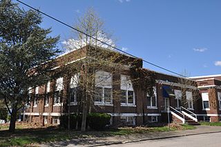
The North End Historic District is a historic district in Woonsocket, Rhode Island encompassing an affluent residential area developed predominantly between about 1880 and 1930. It is bounded by Harris Avenue on the west, Winter Street on the north, Summer and Prospect Streets to the east, and Spring and Blackstone Streets to the south. It is separated from Woonsockets commercial and industrial heart by a neighborhood of densely populated worker housing. Most of the district's 224 major buildings are of relatively high quality and in good condition, and are reflective of the architectural styles that predominated in the late 19th and early 20th centuries: Queen Anne Victorian, Colonial Revival, and Tudor Revival forms and styles are the most common seen.
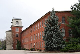
The Richmond Paper Company Mill Complex is an historic American paper mill at 310 Bourne Avenue in East Providence, Rhode Island. It consists of a collection of mainly brick buildings on 13 acres (5.3 ha) of land, bounded on the north by Bourne Avenue, the east by railroad tracks, the west by the Seekonk River, and on the south by land formerly owned by the Washburn Wire Company. The first seven of the surviving buildings were built between 1883 and 1887 by the Richmond Paper Company. The property was acquired at auction in 1894 by Eugene Phillips, who operated the American Electrical Works on the premises, adding further buildings between 1900 and 1930 and demolishing several buildings specific to paper processing. The property presently sees a variety of light industrial uses. The Richmond Paper Company is notable as the place where Arthur Dehon Little started his career.

The Parkis–Comstock Historic District is a residential historic district in the Elmwood neighborhood of Providence, Rhode Island. It includes all of the properties on Parkis Avenue and a number of properties on the western end of Comstock Street and Harvard Avenue, just across Broad Street from Parkis. The houses are set on relatively uniform large lots, generally set close to the street, and represent a fine collection of Late Victorian upper-class housing. Most of the houses were built between the 1860s and the 1910s. The first house to be built on Parkis Avenue was the c. 1869 Louis Comstock House at number 47; it has fine Second Empire styling, with corner quoining and a bracketed mansard roof.

The Providence Jewelry Manufacturing Historic District is a predominantly industrial historic district in Providence, Rhode Island. It covers a roughly 19-acre (7.7 ha) area just south of Downtown Providence, and was originally bounded by Interstate 195 prior to a realignment in the 2000s which reconnected the two areas. Although the area began as a residential area, and still has some houses in it, it developed in the late 19th and early 20th centuries as a center of Providence's jewelry manufacturing businesses. The oldest industrial building in the district is the 1848 Elm Street Machine Shop, a 2 1⁄2-story stone structure that now houses offices of Brown University.
The Stimson Avenue Historic District is a residential historic district on the east side of Providence, Rhode Island. It includes all of Stimson Avenue and Diman Place, as well as adjacent properties on Angell Street on the south and Hope Street on the west, forming a relatively compact rectangular area. This area was developed roughly between 1880 and 1900, and features a collection of high-quality Queen Anne and Colonial Revival houses, with a few earlier Italianate houses at its edges. Among the finest is 19 Stimson Avenue, built in 1890 to a design by Stone, Carpenter & Willson; it is stylistically transitional between Queen Anne and Colonial Revival, featuring elaborate woodwork and a large number of exterior surface finishes, in a predominantly symmetrical Colonial Revival form. The only non-residential structure is the 1893 brick Central Congregational Church at 296 Angell Street.

The Hope Village Historic District encompasses a historic mill village located in Scituate, Rhode Island. Located on a bend in the Pawtuxet River in southeastern Scituate, the area has seen industrial activity since the 18th century, and has surviving industrial and residential buildings from the early 19th century. The village is centered on the junction of Main Street and North Road, and radiates out from there, with numerous properties on smaller side streets. The present main mill building was built in 1844 by Brown & Ives, operators of numerous Rhode Island textile mills. Approximately 1/4 of the village's housing stock originated as mill worker housing built by the company.
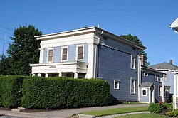
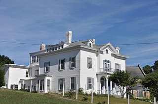
Lafayette Village is a historic district extending along Ten Rod Road in North Kingstown, Rhode Island. It encompasses a linear rural and industrial village, running from the Wickford Junction railroad crossing in the west to Angel Avenue in the east, and includes a number of residential properties on adjacent side streets. The centerpiece of the district is the Rodman Manufacturing Company complex, which operated here for a century beginning in the 1840s. The Robert Rodman Mansion, a Second Empire house with an elaborate porch, stands at 731 Ten Rod Road, and the Walter Rodman House, built in the 1870s, is even more elaborately decorated. Most of the residential stock in the district is mill-related housing built by the Rodmans for their workers.
The Main Street Historic District of Westerly, Rhode Island, encompasses a predominantly residential section of Main Street and adjoining Maple Avenue and School Street. The district includes nineteen houses, which are predominantly Greek Revival, Italianate, and Second Empire in style, as well as the Pawcatuck Seventh Day Baptist Church, a Greek Revival structure built 1847-48.
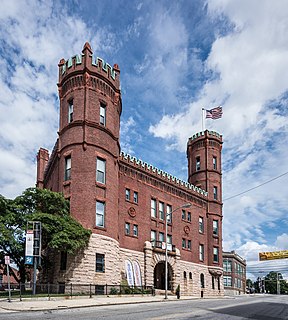
The Westerly Armory is an historic National Guard armory building located on Railroad Avenue, west of downtown Westerly, Rhode Island.

Collyer Monument is an historic monument to firefighters in Mineral Spring Park, at the corner of Mineral Spring Avenue and Main Street, in Pawtucket, Rhode Island, United States. The monument was built in 1890 by the sculptor Charles Parker Dowler to honor Samuel Smith Collyer, a fallen Pawtucket Fire Chief. The life-size bronze sculpture stands atop a pedestal of Westerly granite which contains a bronze plaque showing the fatal accident and the reverse bears the inscription. The Collyer Monument represents a significant example of monumental work of the period and an early example of local civic pride. The monument was added to the National Register of Historic Places in 1983.
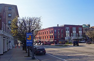
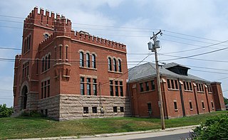
The Exchange Street Historic District is an industrial and civic historic district roughly along Exchange, Front and Fountain Streets in Pawtucket, Rhode Island. The 10.5-acre (4.2 ha) area is located just north of Pawtucket's downtown, and includes seven buildings and the Exchange Street Bridge, which spans the Blackstone River. The seven buildings are sandwiched between the river to the west, Broadway to the east, Blackstone Avenue to the north, and Front and Exchange Streets on the south. The most prominent buildings in the district are the 1926 William E. Tolman High School, sited high above the river just north of Exchange Street, and the Pawtucket Armory, built in 1895 and featuring crenellated towers. South of Exchange Street stand several mill buildings dating as far back as 1874.

Highland Heights–Stevens' Subdivision Historic District is a residential historic district located in Highland Park, Michigan along five east-west streets: Farrand Park, McLean Street, Colorado Street, Rhode Island Street, and Massachusetts Street, between Woodward Avenue on the west and Oakland Avenue on the east. The district was listed on the National Register of Historic Places in 1988.

The Greystone Historic District is a historic district encompassing the early 20th-century mill village of Greystone in North Providence, Rhode Island. The district most significant elements is the Greystone Mill, a complex of brick industrial buildings on the North Providence side of the Woonasquatucket River, as well as the dam spanning the river and a water tank in Johnston. The village, entirely in North Providence, was developed between 1904 and 1912 by Joseph Benn and Company, the mill proprietors, to provide housing for its workers. The main focus of the village is on junction of Greystone Road and Oakleigh Avenue. The company built a variety of housing types, including duplexes and tenements, which line some of the side streets. There are four houses, dating as far back as 1822, that predate the primary industrial activity here. The most prominent feature of the village is the Greystone (Primitive) Methodist Church on Oakleigh Avenue.
The Phillipsdale Historic District encompasses a historic mill village along the Seekonk River in East Providence, Rhode Island. The village grew up around the Richmond Paper Company Mill Complex, built 1883-1887, which is separately listed on the National Register. It also includes 75 units of worker housing, as well as five houses that predate the mill complex's construction. The Phillipsdale area was the largest source of employment in East Providence between 1893 and 1910. The district is centered on Roger Williams Avenue and Bourne Avenue, and includes properties on Ruth Avenue and the grid of roads between Ruth and Roger Williams. It also includes Omega Pond.

The Edgewood Historic District–Anstis Greene Estate Plat is a residential historic district in the Edgewood neighborhood of eastern Cranston, Rhode Island. The 34-acre (14 ha) area is bounded on the west by Broad Street, the east by Narragansett Bay, the south by Rosewood Avenue, and on the north by Marion Avenue, where it abuts the Edgewood Historic District-Shaw Plat. The area, originally part of a much larger property belonging to Zachariah Rhodes in the 17th century, was platted for residential development in the decades following the arrival of the streetcar on Broad Street, providing commuter service to Providence. The land was willed by Anstis Rhodes Greene to a group of heirs, who progressively developed their individual portions. The only significant surviving elements that predate this development are two small family cemeteries.