
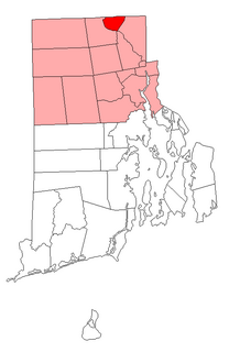
Woonsocket, is a city in Providence County, Rhode Island, United States. The population was 41,186 at the 2010 census, making it the sixth largest city in the state. Being Rhode Island’s northernmost city, Woonsocket lies directly south of the Massachusetts state line and constitutes part of both the Providence metropolitan area and the larger Greater Boston Combined Statistical Area.

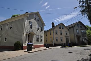
Union Village or "Bank Village" is a village and historic district located in North Smithfield and Woonsocket, Rhode Island on Rhode Island Route 146A. Union Village developed because it was at the cross roads of old Great Road and Pound Hill Road.

The Smithfield Friends Meeting House, Parsonage and Cemetery, is a Friends Meeting House of the Religious Society of Friends (Quakers), rebuilt in 1881. It is located at 108 Smithfield Road in Woonsocket, Rhode Island. The meetinghouse is home to one of the oldest Quaker communities in the region.

The Warren Waterfront Historic District encompasses the center of Warren, Rhode Island. It is bounded on the west by the Warren River, on the north roughly by Belcher Cove, on the east roughly by Federal and Main Streets, and on the south by Campbell Street. This area is a densely built residential, commercial, and civic area that has been the center of Warren since the mid-18th century. The town prospered in the 19th century, first as a whaling and shipbuilding center and later with industrial development. The district includes the town's major civic buildings, as well as a wide variety of housing in 19th century revival and Victorian styles. It was listed on the National Register of Historic Places in 1974, and enlarged in 2003.

The Cato Hill Historic District is a residential historic district in central Woonsocket, Rhode Island. It consists of about 2-1/2 blocks of Church and Cato Streets, as well as the streets crossing them. The area, located on a hill just above Woonsocket's downtown area, is a densely populated area built primarily between 1838 and 1875, during Woonsocket's growth as a major textile processing center. Cato Hill is named for Cato Aldrich, an African American who purchased the land from the Arnolds who founded Woonsocket. The houses of the district exhibit vernacular forms of the architectural styles popular in the mid-19th century.

The Island Place Historic District is a historic district at Island Place and South Main Street at Market Square in Woonsocket, Rhode Island. The district includes six historic buildings, three of which are part of the Woonsocket Rubber Company Mill, dating from c. 1857 to c. 1919. The other buildings in the district are the Island Machine Company, the Barnai Worsted Company Dyeworks, and a wood-frame structure, that is the last surviving elements of the Wilkins Manufacturing Company. The district is bounded by Market Square, Bernon Street, and a bend in the Blackstone River. The site is now home to the Museum of Work & Culture, a project of the Rhode Island Historical Society.

The Main Street Historic District is a historic district in the central business district of Woonsocket, Rhode Island, USA. It extends along Main Street, between the railroad tracks just northeast of its junction with Clinton Street, and roughly Ascension Street at the southwest. Most of the sixteen buildings in this area were built at the height of Woonsocket's prosperity, roughly between 1850 and 1930. The district is characterized by brick and masonry buildings generally between two and six stories in height.

The South Central Falls Historic District is a historic district in Central Falls, Rhode Island. It is a predominantly residential area, densely populated, which was developed most heavily in the late 19th century. It is bounded roughly by Broad Street to the east, the Pawtucket city line to the south, Dexter Street to the west, and Rand Street and Jenks Park to the north. It has 377 contributing buildings, most of which were built before 1920. The district was added to the National Register of Historic Places in 1991.

The Woonsocket District Courthouse is an historic court building on 24 Front Street in Woonsocket, Rhode Island.

The Woonsocket Company Mill Complex is a historic district encompassing one of the largest mill complexes in Woonsocket, Rhode Island. The district includes all of the buildings historically associated with the Woonsocket Company, a major manufacturer of cotton textiles in the 19th century. The complex is located along the eastern bank of the Blackstone River between Court and Bernon Streets. It includes three handsome stone mills, built between 1827 and 1859, and a power plant that was built on the site of the former #3 mill between 1890 and 1920, as well as the remnants of the canal that originally carried water to the buildings for power.

The St. Charles Borromeo Church is a former Roman Catholic parish church in Woonsocket, Rhode Island, located on North Main Street. The parish of St. Charles was canonically suppressed January 12, 2020 and the congregation merged with that of the Church of All Saints, another parish of the Diocese of Providence, although the church remains open as an alternative worship space.

St. Andrew's Episcopal Chapel is an historic Episcopal church located at 576 Fairmont Street in Woonsocket, Rhode Island.

The South Main Street Historic District is a residential historic district in Woonsocket, Rhode Island. It extends along South Main Street between Mason Street on one end and Andrews and Bradford Streets on the other, and includes properties on adjacent streets, principally Ballou and North Ballou Streets. The district includes 65 main properties, most of which were built between 1880 and 1930, although there is a cluster of older properties in the northern half of the district. The district typifies the American main road leading into a town, lined by landscaped lots with high-quality houses.
The Bridgham–Arch–Wilson Streets Historic District is a predominantly residential historic district in Providence, Rhode Island. It is located southwest of downtown Providence, and was developed beginning in the 1840s as a suburban part of the city. It is roughly in the shape of a boot, roughly bounded by Cranston, Bridgham, Elmwood, and Harrison Streets. Most of the housing is architecturally reflective of the mid-19th century, with the Greek Revival, Italianate, and Second Empire styles well represented. Development in the area slowed in the late 19th and early 20th centuries, so there are only a modest number of Queen Anne, Stick style, and Colonial Revival properties. Most of the houses are either 1-1/2 or 2-1/2 story wood frame structures, and are generally set on fairly small lots. There are 175 primary buildings in the district, of which more than 150 are historically significant.

The Wayland Historic District is a predominantly residential historic district on the east side of Providence, Rhode Island. It is a large area, covering about 122 acres (49 ha), bounded roughly on the north by Everett and Laurel Avenues, on the east by Blackstone Boulevard and Butler Avenue, on the west by Arlington Avenue, and on the south by Angell and South Angell Streets. This area, which was in the 19th century part of the Moses Brown farm, was platted for development in 1891, with most of the construction taking place in the early decades of the 20th century. Most of the residential properties in the district are single-family houses, typically built in revival styles popular at the time. They are set on similarly-sized lots with fairly uniform setbacks, and were typically built without garages. There are a number of two-family houses, and a small number of apartment buildings, most of which are found on the arterial roads of the area. There are several religious buildings, including several churches; the most architecturally distinctive religious building is the Jewish Temple Beth El, built 1951–54.

The South Street Historic District encompasses a small enclave of 19th-century houses on South Street between Meadow and Fruit Streets in Pawtucket, Rhode Island. Covering two blocks of South Street, it includes 21 buildings, of which 15 were built before 1850, and the rest before 1900. Most of the houses are 1-1/2 story wood frame structures, with many of the larger ones showing signs of having once been of a similar size. The most common architectural style is the Greek Revival, with notable examples at 19-21 and 37-39 South Street.

The South Main Street Historic District is a historic district in Coventry, Rhode Island. It extends along South Main Street from its crossing of the South Branch of the Pawtuxet River in the north, to just below Wood Street in the south, and includes a few properties on immediately adjacent streets. The area is almost entire residential, and was developed in the 19th century, providing housing for middle-class workers not directly affiliated with the mills that lined the river. About half the houses were built before 1850, and exhibit either Federal or Greek Revival styling, while most of the remaining houses were built before 1920. The principal non-residential structures are a VFW hall, which began as a mid-19th century residential structure associated with Rhode Island's prominent Whipple family, the Stillwater Company mill at the northern end of the district (1914), and the three-room Cady Street Schoolhouse (1844).
This is a list of National Register of Historic Places listings in Woonsocket, Rhode Island.
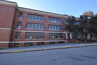
The Woonsocket Senior High and Junior High Schools is an historic school complex at 357 Park Place in Woonsocket, Rhode Island. Built in 1914 and enlarged several times, it served as the city's high school until 1967, and as the Woonsocket Middle School until its closure in 2009. The building was listed on the National Register of Historic Places in 2017.

The First Universalist Church is a former Universalist church at 78 Earle Street in Woonsocket, Rhode Island. Built in 1924 and enlarged in 1957, it is a good example of 20th-century Gothic Revival architecture. The congregation for which it was built was established in the 1820s, in part through the efforts of Hosea Ballou, an influential early Universalist minister who also had business interests in Woonsocket. The congregation was disbanded in 2007, and the building now houses the American-French Genealogical Society. It was listed on the National Register of Historic Places in 2020.


