
The Magnificent Mile is a section of Michigan Avenue in Chicago devoted to retail, dining, hotels and tourist attractions. Running from the Chicago River to Oak Street in the Near North Side, the district is located one block east of Rush Street and is the main retail corridor between the Loop and Gold Coast. It is bounded by Streeterville neighborhood to its east and River North to its west.
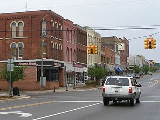
The Main Street Historic District in Tampico, Illinois, United States, is a historic district notable as home to the birthplace of Ronald Reagan. The district includes the late 19th century collection of buildings that comprise Tampico's central business district; among them are two apartments that the Reagan family occupied in the early 1900s. The buildings in the district went through several periods of rebuilding during the 1870s due to major fires and a tornado. The district boundaries encompass the 100 block of Main Street and exclude properties that do not date from the historic period.

The High Falls Historic District corresponds roughly to the downtown section of the hamlet of that name in Marbletown, New York, United States. It is a 21-acre (8.5 ha) area around the intersection of state highway NY 213, Main Street, Mohonk Road (Ulster County Route 6A0 and Bruceville Road just south of Rondout Creek.

The West Vernor–Lawndale Historic District is a two-block commercial historic district located along West Vernor Highway between Cabot and Ferris Streets in Detroit, Michigan. The district includes 30 acres (120,000 m2) and 10 buildings. It was listed on the National Register of Historic Places in 2002.
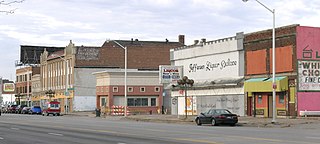
The Jefferson–Chalmers Historic Business District is a neighborhood located on East Jefferson Avenue between Eastlawn Street and Alter Road in Detroit, Michigan. The district is the only continuously intact commercial district remaining along East Jefferson Avenue, and was listed on the National Register of Historic Places in 2004.

The Lake Street Historic District is located along the west side of that street, state highway NY 19, in downtown Bergen, New York, United States. It contains several of Romanesque Revival style buildings from the last decades of the 19th century and the first two of the early 20th. Most were built after the village banned wooden buildings following two devastating fires in the area. One is currently used as Bergen's municipal building.
Prairie Avenue is a north–south street on the South Side of Chicago, which historically extended from 16th Street in the Near South Side to the city's southern limits and beyond. The street has a rich history from its origins as a major trail for horseback riders and carriages. During the last three decades of the 19th century, a six-block section of the street served as the residence of many of Chicago's elite families and an additional four-block section was also known for grand homes. The upper six-block section includes part of the historic Prairie Avenue District, which was declared a Chicago Landmark and added to the National Register of Historic Places.

The Greenwich Avenue Historic District is a historic district representing the commercial and civic historical development of the downtown area of the town of Greenwich, Connecticut. The district was listed on the National Register of Historic Places on August 31, 1989. Included in the district is the Greenwich Municipal Center Historic District, which was listed on the National Register the year before for the classical revival style municipal buildings in the core of Downtown. Most of the commercial buildings in the district fall into three broad styles, reflecting the period in which they were built: Italianate, Georgian Revival, and Commercial style. The district is linear and runs north–south along the entire length of Greenwich Avenue, the main thoroughfare of Downtown Greenwich, between U.S. Route 1 and the New Haven Line railroad tracks.

The Moline Downtown Commercial Historic District is a nationally recognized historic district located in Moline, Illinois, United States. Centered on 5th Avenue, it is roughly bounded by 12th Street to 18th Street, 4th Avenue to 7th Avenue. The distinct covers 33-acre (0.13 km2) and includes 114 buildings. One hundred of the buildings contribute to the significance of the district because they retain their historic and architectural integrity and reflect the character of the historic downtown.
The Belvidere South State Street Historic District is a historic district on the north side of the Kishwaukee River in Belvidere, Illinois. It is primarily composed of commercial building representative of architectural trends from 1852 to 1962, the period following the connection of the city to the Galena and Chicago Union Railroad.

The Alma Downtown Historic District is a commercial historic district in Alma, Michigan, roughly located along Superior Street between the Pine River and Prospect Avenue, and along State Street between Center and Downie Streets. Parts of the district were designated a Michigan State Historic Site in 1975, and the entirety was listed on the National Register of Historic Places in 2013. It contains 72 structures, primarily brick commercial buildings, ranging from one to three stories in height and dating from 1874 to the 1960s.

The Bristol Downtown Historic District encompasses the historic late 19th-century commercial heart of Bristol, Vermont. At first a rural agricultural market town, it developed in the second half of the 19th century as a small industrial center, producing finished wood products. Its downtown occupies an area of one block on both sides of Main Street, and features a diversity of architectural styles. It was listed on the National Register of Historic Places in 1983.

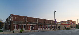
The New Center Commercial Historic District is a commercial historic district located on Woodward Avenue between Baltimore Street and Grand Boulevard in Detroit, Michigan. It was listed on the National Register of Historic Places in 2016.
The Niles Downtown Historic District is a commercial historic district located in Niles, Michigan along Sycamore, Main and Cedar Streets between Front and 5th. The districts was listed on the National Register of Historic Places in 2007.

The Buchanan Downtown Historic District is a primarily commercial historic district located in Buchanan, Michigan between 117 W. and 256 E. Front Street and between 108 and 210-212 Main Street, along with adjacent sections of Oak Street and Days Avenue. The district was listed on the National Register of Historic Places in 2009.
The West Side Third Avenue SW Commercial Historic District is a nationally recognized historic district located in Cedar Rapids, Iowa, United States. It was listed on the National Register of Historic Places in 2014. At the time of its nomination it consisted of 10 resources, which included seven contributing buildings and three non-contributing buildings. Cedar Rapids was platted on the east bank of the Cedar River as Rapids City in 1841, and it was incorporated in 1849. Kingston was established on the west bank of the river in 1852, and it was annexed by Cedar Rapids in 1870. The streets were laid out parallel and perpendicular to the river, which flowed from the northwest to the southeast. The Chicago, Iowa & Nebraska Railway, later the Chicago & North Western Railway, was the prominent railroad on the west side of town. The first bridge across the river at Third Avenue was built in 1871. The current bridge was completed in 1912. Prior to a bridge, Rapid City and Kingston were connected by a ferry operated by David W. King, the founder of Kingston.

The Ionia Downtown Commercial Historic District is a primarily commercial district located roughly along West Main and Washington Streets, from Dexter Street to Library Street, in Ionia, Michigan. The district was listed on the National Register of Historic Places in 1984.

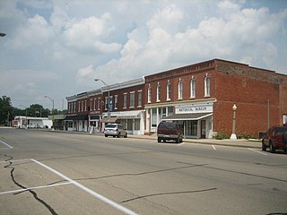
The Island City Historic District is a primarily commercial historic district which encompass the whole of the island on which stands the central part of Eaton Rapids, Michigan. It was listed on the National Register of Historic Places in 2012.

The Valley Junction Commercial Historic District is a nationally recognized historic district located in West Des Moines, Iowa, United States. It was listed on the National Register of Historic Places in 2017. At the time of its nomination it consisted of 72 resources, which included 53 contributing buildings, 17 non-contributing buildings, and two non-contributing structures. What is now the city of West Des Moines was incorporated as Valley Junction in 1893. Its central business district, which is the subject of this historic district, developed near the depot of the Chicago, Rock Island and Pacific Railroad. The railroad also had their shops (non-extant) to the southwest of the district in an angle formed by the junction. The linear historic district is composed of most of three blocks of Fifth Street and parts of two cross streets.
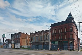
The Michigan Avenue Historic Commercial District in Detroit is a group of commercial buildings located along the south side of two blocks of Michigan Avenue, from 3301–3461. This section of buildings is the most intact collection along this stretch of Detroit's Michigan Avenue. The district was listed on the National Register of Historic Places in 2020.


