Norwell, Nottinghamshire

Last updated

Norwell
Village and civil parish
St. Laurence, Norwell - geograph.org.uk - 124518.jpg
Norwell, Nottinghamshire
Parish map
Nottinghamshire UK location map.svg
Red pog.svg
Norwell
Location within Nottinghamshire
Area4.71 sq mi (12.2 km2)
Population470 (2021)
  Density 100/sq mi (39/km2)
OS grid reference SK 7761
  London 115 mi (185 km)  SSE
District
Shire county
Region
Country England
Sovereign state United Kingdom
SettlementsNorwell
Norwell Woodhouse
Post town Newark
Postcode district NG23
Dialling code 01636
Police Nottinghamshire
Fire Nottinghamshire
Ambulance East Midlands
UK Parliament
Website www.hugofox.com/community/norwell-parish-council-20448/home
List of places
UK
England
Nottinghamshire
53°08′50″N0°50′55″W / 53.1472°N 0.8486°W / 53.1472; -0.8486

Norwell is a village and civil parish about 6 miles (9.7 km) from Newark-on-Trent, in central Nottinghamshire, England. The population (including Norwell Woodhouse) at the 2011 census was 490, [1] this declined to 470 at the 2021 census. [2] It is close to the border with Lincolnshire and the River Trent, and lies approximately 1.5 miles (2.4 km) from the A1 road and 1 mile (1.6 km) from the East Coast Main Line.

Contents

History

Early history

"Nortwelle" [3] is mentioned in the Domesday Book of 1086; it then had a church, a priest and a watermill. The parish consists of Norwell, Norwell Woodhouse, and the now deserted village of Willoughby. For nearly a thousand years the parish of Norwell was owned by the church. Rents from land and houses were used to finance three canons (or prebendaries) of Southwell. The canons were the principal landlords and lived in moated manor houses: Overhall, Palishall and Tertia Pars. In the Middle Ages some prebendaries were national figures, such as Robert de Wodehouse (died 1346) who became treasurer of England. [4]

Farming

In other respects Norwell was a typical farming community. Traces of the medieval open fields, with their ridge and furrow, may still be seen. Major changes followed parliamentary enclosure (1832) when the land was divided into small fields. Many small farms, possibly 28, were established, some in the village centre and others in outlying fields. Today there are a few large farms and no working farms in the village centre. Some old farmyards in the village like Church, Willoughby and Hill farms have been developed for new homes. [4]

Self-sufficiency

19th century Norwell was almost self-sufficient. Blacksmiths, wheelwrights, stonemasons, and builders were often grouped together in yards leading off the main street. There were two windmills, two steam mills and a watermill. For a time Norwell had its own brickworks. Personal needs were met by General stores, bakers and butchers, shoemakers and a tailor. There were at least three public houses; The Black Horse, The Crown (later The Elephant and Castle) and The Plough. Norwell has had a school since 1727. [4]

Buildings

The medieval church of St Laurence is Grade 1 listed and has features from the 12th to the 20th century. Almost all of the buildings are of red brick with pantiles. There are many timber-framed buildings originally with mud and stud between the timbers. Most are now entirely encased in brick but the timber can still be seen internally. There are a few striking 19th-century houses, most of which were built by Henry Clipsham, the Norwell builder who also restored the Church. A windmill and distinctive circular pinfold can still be seen.

Norwell now

The population of the parish is about 470, much as it was around 1250 and 1700. It reached its peak in the 1860s when it was nearly 800.[ citation needed ]

Norwell Buildings

St. Laurence Church

Brief history

The first church in Norwell was almost certainly a wooden one, probably erected as a chapel attached to an Anglo-Saxon manor house standing on or near where a later moated manor house was built, immediately to the south of the present church. This may have been the church, with its priest, mentioned in the Domesday Book, but no traces of that chapel or church remain. Shortly after 1100 it was certainly replaced by a small rectangular building like that surviving at Littleborough, Nottinghamshire. Fragmented masonry associated with this first stone church has been identified in the north aisle. [5] [6] [7] [8]

St Laurence's Church, Norwell Norwell church.jpg
St Laurence's Church, Norwell

During the 12th and 13th centuries other traces were lost through major work creating the church we now see. Around 1180–1200, the south aisle was added and the south door moved to its present position. A tower with three storeys was built shortly after 1200 and by 1250 the north aisle was added. A further expansion took place around 1300, partly paid for by a legacy from Mr John Clarell, prebendary of Overhall (d.1295). The north and south transepts were added, the Chancel lengthened and, a few years later, the south porch built. Finally between about 1450 and 1500, the nave was heightened with a clerestory (a row of flat-headed windows) inserted, the transepts and Chancel were re-roofed, and a fourth storey with battlements and gargoyles was added to the tower. The 19th-century, largely sympathetic, restoration (Chancel, 1857-8, rest of church, 1872-5) by Ewan Christian faithfully preserves St Laurence's medieval appearance. The only major structural change was that Christian restored the Chancel to its 13th-century form by removing the low-pitched roof that was part of the 15th-century refurbishment. [5] [6] [7] [8]

St Laurence's Church, Norwell St.Laurence's church nave - geograph.org.uk - 263828.jpg
St Laurence's Church, Norwell

Evidence from the church shows the wide variety of stone available in medieval Norwell. Much of the building is constructed in skerry, a form of pale grey sandstone, quarried locally at Tuxford, Laxton, Kneesall and Maplebeck. Magnesium limestone was brought from Mansfield and other limestone came from Ancaster in Lincolnshire, whilst local lias from Collingham and a light porous tufa, which outcrops in The Beck between Norwell and Caunton, has been identified. For high-quality monuments like tombs and effigies, stone was sometimes imported over much longer distances, like the Purbeck marble and Caen stone also present. [5] [6] [7] [8]

Methodist Chapel

The Primitive Methodist Chapel was built on land donated by Revd W.Sturtevant in 1827. In 1843 this chapel was bought by the Wesleyans, who re-opened it on 6 November. This flourished and was enlarged in 1909, with a school room built by Henry Clipsham & Sons at a cost of £337. It became a private house in 1991.

The Pinfold

Norwell Pinfold Norwellpinfold 1.jpg
Norwell Pinfold

The village pinfold or pound is located on Bathley Lane (west side) close to its junction with Main Street and Woodhouse Road. The 18th century circular structure is of brick with half round ashlar copings with a pair of square gate pillars with ashlar capitals. The wooden gate is 20th century. The pinfold is approximately 10m (33') in diameter and is reputedly the largest round pinfold in the county (Nottinghamshire).

The structure is Grade II listed by Historic England (listing number 1045950). [9]

An attached plaque carries the inscription:

PINFOLD
BUILT CIRCA 1830
TO REPLACE AN EARLIER
WOODEN PINFOLD USED TO
PEN STRAY ANIMALS WHICH
COULD THEN BE RECLAIMED
ON PAYMENT OF A FINE
TO THE PINDER
[Signed] NORWELL PARISH COUNCIL

Transport

Road

Norwell roads including Main Street, Carlton Road, Ossington Road, Bathley Lane and Woodhouse Road are unclassified. The speed limit through the village is 30 mph with an advisory 20 mph along part of Main Street due to the proximity of the school.

The A1 Trunk Road (Cromwell Bypass) passes the parish approximately 1.5 miles to the east of Norwell. Although not within the parish it is of interest that Cromwell Bypass was the location of highly collaborative trials of the slip-form paver in 1964/65. [10] The first such machine to be brought into the UK was used to trial the laying of unreinforced and reinforced concrete carriageways with dowelled contraction and expansion joints. The surface has now been rebuilt using tarmac (asphalt concrete). The A616 road passes approximately 2 miles to the west of Norwell.

Rail

The East Coast Main Line crosses the east of the parish in an approximately north/south direction, passing approximately 1 mile to the east of the village itself.

The nearest railway stations are in Newark-on-Trent, seven miles to the south-east. Newark North Gate is located on the East Coast Main Line, between London King's Cross and Edinburgh Waverley, and Newark Castle is located on the Nottingham to Lincoln line.

See also

Related Research Articles

<span class="mw-page-title-main">Southwell, Nottinghamshire</span> Cathedral town in Nottinghamshire, England

Southwell is a minster and market town, and a civil parish, in the district of Newark and Sherwood in Nottinghamshire, England. It is home to the grade-I listed Southwell Minster, the cathedral of the Anglican Diocese of Southwell and Nottingham. The population of the town was recorded at 7,491 in the 2021 census.

<span class="mw-page-title-main">Lowdham</span> Village in Nottinghamshire, England

Lowdham is a village and civil parish in the Newark and Sherwood district of Nottinghamshire between Nottingham and Southwell. According to the 2021 census, it had a population of 3,247. Two main roads slicing through the village are the A6097 south-east to north-west and the A612 between Nottingham and Southwell.

<span class="mw-page-title-main">Widmerpool</span> Village and civil parish in Nottinghamshire, England

Widmerpool is a village and civil parish in Nottinghamshire, about 10 miles south-south-east of Nottingham and some 7.5 miles north-east of Loughborough. It is one of Nottinghamshire's oldest settlements and is just over a mile west of the A46. Extensive dual carriageway road works along the A46 have now been completed. At the time of the 2001 census it had a population of 262, increasing to 339 at the 2011 census, and falling slightly to 327 residents at the 2021 census. Until the 1960s there had not been any building in the village for 100 years.

<span class="mw-page-title-main">Balderton</span> Village and civil parish in Nottinghamshire, England

Balderton is a village and civil parish in Nottinghamshire, England, which had a population of 9,757 at the 2011 census, increasing to 9,917 at the 2021 census.

<span class="mw-page-title-main">Besthorpe, Nottinghamshire</span> Village in Nottinghamshire, England

Besthorpe is a small village in north-east Nottinghamshire close to the border with Lincolnshire. It is a civil parish in the Newark & Sherwood district of Nottinghamshire. The population of the civil parish as of the 2011 census was 195, increasing to 212 at the 2021 census. The village is on the A1133 between Newark and Gainsborough, and is 1.5 miles north of the larger village of Collingham, north east of Newark on Trent. The village lies 1 mile east of the River Trent and the River Fleet flows south to east parallel with the village & A1133. Besthorpe acquired Conservation Village status in 2006 because it has maintained much of its original layout focused on Low Road and the Green.

<span class="mw-page-title-main">East Hagbourne</span> Village in England

East Hagbourne is a village and civil parish about 1 mile (1.6 km) south of Didcot and 11 miles (18 km) south of Oxford. It was part of Berkshire until the 1974 boundary changes transferred it to Oxfordshire. The 2011 Census recorded the parish's population as 1,882.

<span class="mw-page-title-main">Upton, Newark and Sherwood</span> Village in Nottinghamshire, England

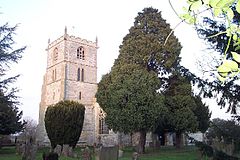
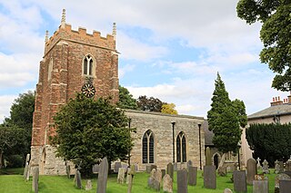
Upton is a small village in Nottinghamshire, England, 2 miles (3.2 km) east of Southwell, 5 miles (8.0 km) west of Newark and 3 miles (4.8 km) south of Hockerton; it lies on the A612 Nottingham-Newark road. In 1889, the village was described as sitting on a bend in the main road, "on the summit of a hill which commands a fine view of the Trent Valley.... The church, which is a prominent feature in the landscape, has a substantial Perpendicular tower crowned by eight pinnacles, and having in the centre a lofty master pinnacle which rises above its neighbours, and so adds materially to the effect."

<span class="mw-page-title-main">Elston</span> Village in Nottinghamshire, England

Elston is a village and civil parish in the Newark and Sherwood district, in Nottinghamshire, England, to the south-west of Newark, 0.5 mi (800 m) from the A46 Fosse Way. The population of the civil parish taken at the 2011 census was 631, increasing to 697 at the 2021 census. It lies between the rivers Trent and Devon, with the village "set amongst trees and farmland less than a mile from the A46.... Newark is five miles to the north, with... Lincoln and Nottingham some 18 miles north and south-west respectively."

<span class="mw-page-title-main">Horningsham</span> Human settlement in England

Horningsham is a small village and civil parish in Wiltshire, England, on the county border with Somerset. The village lies about 4 miles (6 km) southwest of the town of Warminster and 4+12 miles (7 km) southeast of Frome, Somerset.

<span class="mw-page-title-main">Skegby</span> Human settlement in England

Skegby is a village in the Ashfield district of Nottinghamshire, England. It lies on the B6014 road, two miles west of Mansfield and one mile north of Sutton-in-Ashfield, close to Stanton Hill. Skegby sits on both sides of a deep valley near the source of the River Meden. It was a civil parish until 1935, when it was absorbed into Sutton-in-Ashfield.

<span class="mw-page-title-main">Irby in the Marsh</span> Village and civil parish in Lincolnshire, England

Irby in the Marsh is a village and civil parish in the East Lindsey district of Lincolnshire, England. It is situated on the B1195 road, geographically 4.5 miles (7 km) east from Spilsby and 6 miles (10 km) west from Skegness.

<span class="mw-page-title-main">Kinoulton</span> Village and civil parish in Nottinghamshire, England

Kinoulton is a village, civil parish and ecclesiastical parish in Nottinghamshire, England, 10 miles (16 km) south east of the city of Nottingham. It is probably Saxon in origin, and once had a brick-making industry. It is close to the A46 road, and has a population of about 1,000.

<span class="mw-page-title-main">South Leverton</span> Village and civil parish in Nottinghamshire, England

South Leverton is a village and civil parish in Bassetlaw, north Nottinghamshire, England, four miles from Retford. According to the 2001 census it has a population of 478, increasing marginally to 480 at the 2011 census, and more substantially to 514 at the 2021 census.

<span class="mw-page-title-main">Hawksworth, Nottinghamshire</span> Village and civil parish in Nottinghamshire, England

Hawksworth is an English conservation village and civil parish in the Rushcliffe borough of Nottinghamshire. It lies 10 miles (16 km) south of Newark-on-Trent, adjacent to the villages of Flintham, Sibthorpe, Thoroton, Scarrington and Screveton.

<span class="mw-page-title-main">St Mary Magdalene Church, Newark-on-Trent</span> Church in Nottinghamshire, England

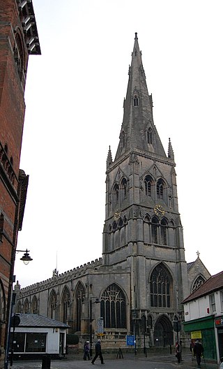
St Mary Magdalene Church, Newark-on-Trent is the parish church of Newark-on-Trent in Nottinghamshire, England. It is dedicated to Mary Magdalene and is the tallest structure in the town.

<span class="mw-page-title-main">Elston Chapel</span> Church in Nottinghamshire, England

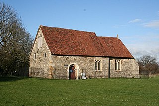
Elston Chapel is a redundant Anglican church to the north-east of the village of Elston, Nottinghamshire, England. It is recorded in the National Heritage List for England as a designated Grade I listed building, and is under the care of the Churches Conservation Trust. It stands in a field and is described as a "solitary barn-like chapel".

<span class="mw-page-title-main">Screveton</span> Village in Nottinghamshire

Screveton is an English civil parish and village in the Rushcliffe borough of Nottinghamshire, with 191 inhabitants at the 2011 census. Screveton singularly reported 164 residents at the 2021 census. It was formerly in Bingham Rural District and before 1894 in Bingham Wapentake. It is adjacent to Kneeton, Flintham, Hawksworth, Scarrington, Little Green and Car Colston.

<span class="mw-page-title-main">Scarrington</span> Village and civil parish in Nottinghamshire, England

Scarrington is an English civil parish and small village in the Rushcliffe borough of Nottinghamshire, adjacent to Bingham, Car Colston, Hawksworth, Orston and Aslockton. Its 968 acres had a population in the 2011 census of 183, falling to 167 at the 2021 census. It lies at Ordnance Survey grid reference SK7341 in the undulating farmland of the Vale of Belvoir, some 2 miles (3.2 km) from the town of Bingham and from a stretch of the Roman Fosse Way (A46) between Newark and Leicester. It is skirted by the A52 road between Nottingham and Grantham.

<span class="mw-page-title-main">Norwell Woodhouse</span> Human settlement in England

Norwell Woodhouse is a small village and former civil parish, now in the parish of Norwell, in the Newark and Sherwood district, in the county of Nottinghamshire, England. It is close to the villages of Caunton, Kneesall, Cromwell and Laxton and around 8 miles (13 km) from Newark-on-Trent. In 1931 the parish had a population of 69.

<span class="mw-page-title-main">Church of St Edmund, Mansfield Woodhouse</span> Church in Nottinghamshire, England

The Church of St Edmund is on Old Manor Road, Mansfield Woodhouse, Nottinghamshire, England. It is an active Church of England parish church in the deanery of Mansfield, the Archdeaconry of Newark, and the Southwell and Nottingham diocese. Its benefice has two churches, St Edmund’s is the main parish church, also the Church of St Chad, Pleasley Vale. The church is recorded in the National Heritage List for England as a designated Grade II* listed building.

References

  1. Norwell. "Neighbourhood Statistics". Office for National Statistics. Retrieved 19 January 2017.
  2. UK Census (2021). "2021 Census Area Profile – Norwell parish (E04007931)". Nomis. Office for National Statistics . Retrieved 5 February 2024.
  3. Ekwall, Eilert , The Concise Oxford Dictionary of English Place-Names. Oxford, Oxford University Press, 4th edition, 1960. p. 345. ISBN   0198691033 .
  4. 1 2 3 Norwell Parish Heritage Group (2007). Michael Jones (Series Editor). Norwell Heritage Trail. Norwell Parish Heritage Group.
  5. 1 2 3 Norwell Parish Heritage Group (2009). Michael Jones (Series Editor). Norwell Heritage Booklet 1 – Norwell Buildings. Norwell Parish Heritage Group. ISSN   2040-2406
  6. 1 2 3 Norwell Parish Heritage Group (2013). Michael Jones (Series Editor). Norwell Heritage Booklet 7 – Norwell Church & Chapel. Norwell Parish Heritage Group. ISSN   2040-2406
  7. 1 2 3 Norwell Parish Heritage Group (2013). Michael Jones (Series Editor). Norwell Heritage Booklet 4 – Norwell Schools. Norwell Parish Heritage Group. ISSN   2040-2406
  8. 1 2 3 Norwell Parish Heritage Group (2009). Michael Jones (Series Editor). Norwell Heritage Booklet 3 – Norwell Mills. Norwell Parish Heritage Group. ISSN   2040-2406
  9. Historic England. "[Norwell] Village Pound (1045950)". National Heritage List for England . Retrieved 24 January 2017.
  10. The National Archives. "Experimental road layouts: concrete roads construction; Cromwell Bypass (A1): slip form paver trials" . Retrieved 5 February 2017.

Commons-logo.svg Media related to Norwell, Nottinghamshire at Wikimedia Commons