Nun's Well, Gibraltar

Last updated

Nun's Well
Nun's Well, Europa Point, Gibraltar.jpg
Nun's Well at Europa Point
Gibraltar location map.svg
Red pog.svg
Location of Nun's Well in Gibraltar
General information
StatusRestored
Location Europa Point, Gibraltar
Coordinates 36°06′42″N5°20′45″W / 36.111556°N 5.345739°W / 36.111556; -5.345739
Construction started Moorish Period (Before 1462)
Renovated1988
Owner Government of Gibraltar
Renovating team
Structural engineer Royal Engineers

Nun's Well is an ancient underground water reservoir in the British Overseas Territory of Gibraltar. It is located at Europa Point, and is thought to be of the Moorish period. It represents some of the earliest evidence of an artificial water supply in Gibraltar. The name of the cistern is thought to be derived from the nuns associated with the Shrine of Our Lady of Europe. In the eighteenth century, Nun's Well supplied the military with water. In the early nineteenth century, it provided water for the brewery that was built next door. In 1988, the Royal Engineers constructed what is now the main building, which has a castle-like appearance. Nun's Well became the focus of controversy during the 2010-2011 restoration of the site.

Contents

Early history

John Drinkwater Bethune Captain John Drinkwater.jpg
John Drinkwater Bethune

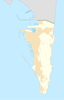
Nun's Well is an ancient subterranean water reservoir in Gibraltar, the British Overseas Territory at the southern end of the Iberian Peninsula. [1] [2] [3] It is located at Europa Point, the southernmost portion of Gibraltar. [4] [5] The cistern is on Europa New Road at Europa Flats, across from the south entrance to Keightley Way Tunnel, just south of the Ibrahim-al-Ibrahim Mosque. On the east side of the structure, the reservoir is accessed by stairs which lead to a door constructed at the underground level. [6] [7] [8] The water reservoir includes a pair of large underground arched chambers into which ground water was permitted to drain. Nun's Well is thought to be of the Moorish period, and represents some of the earliest evidence of the attempts to provide a water supply in Gibraltar. [1] [4] [7]

It is thought that the name of the cistern originated with the nuns who previously cared for the Shrine of Our Lady of Europe, another historic site at Europa Point. [4] Nun's Well is also in proximity to the Europa Point Lighthouse. [9]

In 1753, Governor of Gibraltar Humphrey Bland ordered that the chambers be cleaned. Afterwards, the reservoir supplied the military with water. [7] Nun's Well was described in the second edition of the journal of British officer and military historian John Drinkwater Bethune, A history of the late siege of Gibraltar, published in 1786. [10] [11]

"Towards Europa advance is a Moorish bath, called by the garrison, the Nuns well. It is sunk eight feet deep in the rock, is 72 feet long, and 42 feet broad, and, to preserve the water, has an arched roof, supported by pillars."

Nineteenth century

Prince Edward, Duke of Kent Edward, Duke of Kent and Strathearn by Sir William Beechey.jpg
Prince Edward, Duke of Kent

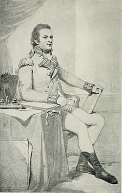
Prince Edward, the Duke of Kent (2 November 1767 23 January 1820), later the father of Queen Victoria, arrived in Gibraltar for the second time in May 1802. His first arrival had been in 1790 as an officer; his second stay at Gibraltar was as Governor, following the death of Governor General Charles O'Hara. Prince Edward was ordered by his brother Prince Frederick, Duke of York to restore discipline at the garrison, as the soldiers spent much of their time inebriated. Before the prince's arrival, Gibraltar had ninety-two taverns which served its approximately 7,000 civilians and soldiers. [12] [13] After his arrival, he closed down the majority of the wine houses that had been frequented by the soldiers. In addition, the Governor ordered that all the remaining taverns be off-limits for the soldiers except for three: The Three Light Infantrymen, The Halfway House, and the Three Guns. [14] He established a brewery at Europa Point, next to Nun's Well. His brewery was known as Brewery Yard or Brewers Yard, and utilised water from Nun's Well. It was the source of “a wholesome supply of Beer for the Troops.” [4] [7] [15] The Duke of Kent was recalled to England in the spring of 1803. [13] Later, in 1805, the brewery was converted into military barracks. [4] [7] [15] The Italian architect Giovanni Maria Boschetti has been credited with demolishing the brewery and constructing a barracks in its place. [16] [17]

In the mid nineteenth century, Nun's Well was described by Spanish historian Ignacio López de Ayala in his History of Gibraltar, published in 1845. [18]

"To the Eastward, and near the Virgen de Europa, was an admirably constructed Cistern or tank for receiving water; so magnificent and of such noble architecture, that it is difficult to divine whether it was the work of the Moors, or of more ancient times. Its shape is that of a Trapezium, seventy-eight feet long, forty-two and forty-eight in width, and eight feet high. Twenty-two solid pillars support the roof, and the descent is by steps, built of bricks. The whole exhibits the result of great perseverance and industry, for it is excavated in a solid rock, and no other place near to it seems fit for such an undertaking. The water collected there is good, and remains sweet throughout the year; but the Cistern has suffered much from the effects of time. (It is still used as a tank, and now bears the name of the Nun's Well.)"

Recent history

John Cortes Dr john cortes.jpg
John Cortes
Peter Caruana Peter Caruana portrait.jpg
Peter Caruana

In the early twentieth century, the military barracks next to the Nun's Well site, referred to as Brewery Barracks, was reported to be in an "insanitary" condition. Discussions at Parliament further indicated that large amounts of money had already been spent on the barracks, and that they were scheduled to be replaced. [4] [7] [19]

In May 1987, the Royal Engineers conducted an investigation of the Nun's Well site. The following year, the Royal Engineers constructed what is now the main building. It has a castle-like appearance; its addition was part of a general restoration of the site. The site of the previous brewery and later barracks is now open ground which is utilised by the military for target practice. [4] [7] While the reservoir had been thought to fill with water that drains along the fractures of the nearby Beefsteak Fault, recent investigation has led researchers to believe that it fills with a combination of rain, street flushing, and sea spray, particularly during levanter winds. [20]

In 2010, the Government of Gibraltar requested that the Gibraltar Ornithological and Natural History Society (GONHS) make suggestions for the landscaping of Europa Point, as the government was intent on restoring the site. A report was completed and contractors transplanted vegetation to the area by Nun's Well to be tended while awaiting replanting. However, irrigation was not provided for the landscaping plants, with the result that most of the plants at Nun's Well died. Another thousand plants that replaced them were also neglected and largely died. Concurrently, an adjacent area which was covered with the strictly protected Gibraltar Sea Lavender (Limonium emarginatum) had rubble dumped upon it. [21] [22] The errors were compounded when replacement planting took place in the heat of summer, and dumping of rubble on the lavender continued. The society contended that the events which transpired were against both the government's own Environment Charter and Environmental Action and Management Plan. [21]

In October 2011, the council of the Gibraltar Ornithological and Natural History Society declined an invitation for its General Secretary John Cortes to attend the inauguration of the recently restored Europa Point. The reasons cited included the destruction of the habitat, the flouting of laws relating to the removal of Gibraltar's protected species, and the ignoring of solicited advice on landscaping with salt-resistant native plants. The decision was criticised by Chief Minister Peter Caruana as a "political stunt." [23] [24] Caruana's statements were denounced by the GONHS as a "vitriolic attack" and a spokesman indicated that their society was an "apolitical ... independent NGO" (non-governmental organization). [25]

Related Research Articles

<span class="mw-page-title-main">Europa Point</span>

Europa Point, is the southernmost point of Gibraltar. At the end of the Rock of Gibraltar, the area is flat and occupied by such features as a playing field and a few buildings. On a clear day, views of North Africa can be seen across the Strait of Gibraltar including Ceuta and the Rif Mountains of Morocco; as well as the Bay of Gibraltar and the Spanish towns along its shores. It is reached from the old town by Europa Road.

<span class="mw-page-title-main">Sandy Bay, Gibraltar</span> Village and beach in Gibraltar

Sandy Bay is a village, bay and beach located on a small bay on the eastern Mediterranean coast of Gibraltar, on the opposite side of The Rock from the main city. It is situated to the south of Catalan Bay and is accessible via Sir Herbert Miles Road.

<span class="mw-page-title-main">Victoria Stadium, Gibraltar</span> Football stadium in Gibraltar

Victoria Stadium is a multi-purpose stadium in Gibraltar. It is currently used mostly for football matches, but also hosts the annual Gibraltar Music Festival. It is located close to Gibraltar Airport just off Winston Churchill Avenue. It was named after the wife of Gibraltarian philanthropist John Mackintosh.

<span class="mw-page-title-main">Barbary macaques in Gibraltar</span> Population of monkeys in Europe

<span class="mw-page-title-main">Shrine of Our Lady of Europe</span>

The Shrine of Our Lady of Europe is a Roman Catholic parish church and national shrine of Gibraltar located at Europa Point. The church is dedicated to Our Lady of Europe, the Catholic patroness of Gibraltar.

<span class="mw-page-title-main">Gibraltar National Museum</span> National museum in Bomb House Lane, Gibraltar

The Gibraltar National Museum is a national museum of the history, culture and natural history of Gibraltar located within the city centre of the British overseas territory of Gibraltar. Founded in 1930 by the then Governor of Gibraltar, General Sir Alexander Godley, the museum houses an array of displays portraying The Rock's millennia-old history and the unique culture of its people. The museum also incorporates the remains of a 14th-century Moorish bathhouse. Its director since 1991 is Prof. Clive Finlayson.

<span class="mw-page-title-main">Line Wall Curtain</span>

The Line Wall Curtain is a defensive curtain wall that forms part of the fortifications of the British Overseas Territory of Gibraltar.

<span class="mw-page-title-main">Streets in Gibraltar</span>

Streets in the British Overseas Territory of Gibraltar are represented by road signs as in the United Kingdom. As of 2007, Gibraltar has a network of 29 kilometres (18 mi) of roads.

<span class="mw-page-title-main">Charles V Wall</span> Defensive wall in Gibraltar

The Charles V Wall is a 16th-century defensive curtain wall that forms part of the fortifications of the British Overseas Territory of Gibraltar. Originally called Muralla de San Benito, it was built in 1540 and strengthened in 1552 by Holy Roman Emperor Charles V. The wall remains largely intact and extends from South Bastion, which was once at the water's edge in the harbour, to the top ridge of the Rock of Gibraltar.

<span class="mw-page-title-main">Grand Casemates Gates</span>

Grand Casemates Gates, formerly Waterport Gate, provide an entrance from the northwest to the old, fortified portion of the city of the British Overseas Territory of Gibraltar, at Grand Casemates Square.

<span class="mw-page-title-main">Levant Battery</span>

Levant Battery is an artillery battery in the British Overseas Territory of Gibraltar. It is located on Windmill Hill, at the southern end of the Upper Rock Nature Reserve, below observation post Fire Control South. It was named after the Levanter cloud, below which it perched, giving it an unobstructed view. Construction started in 1901 and, by 1903, a 9.2-inch Mark X breech-loading gun had been mounted. The battery was decommissioned in the 1970s and the gun was later removed, to rest in a scrap yard. A community group has been formed to garner support for the gun's recovery and restoration.

<span class="mw-page-title-main">Rock Gun Battery</span>

Rock Gun Battery is an artillery battery in the British Overseas Territory of Gibraltar. It is located on the North Face of the Rock of Gibraltar at the northern end of the Upper Rock Nature Reserve, above Green's Lodge Battery. The emplacement on Middle Hill is at the northern summit of the Rock. It was constructed during the Great Siege of Gibraltar, due to its advantageous position and the success of the gun at Green's Lodge Battery. It was used effectively during the Great Siege and was rebuilt during the Second World War. During the mid-twentieth century, the Ministry of Defence began to use the site as an aerial farm, which was then refurbished in 1958. The Rock Gun Battery and the Middle Hill Battery were closed to the public for decades. In 2005, the radio farm was closed and the Ministry of Defence withdrew from most of the area, transferring it to the Government of Gibraltar. However, the summit, the site of the Rock Gun Battery, continues to be under MOD authority.

<span class="mw-page-title-main">Middle Hill (Gibraltar)</span>

Middle Hill is a hill in the British Overseas Territory of Gibraltar. It is located at the northern end of the Upper Rock Nature Reserve. It figured prominently in the early history of the 1704 siege of Gibraltar by the Spanish and French. The artillery battery at Middle Hill had been constructed by 1727 and was active for more than two centuries. In the mid twentieth century, Middle Hill transitioned to use as an aerial farm for the Ministry of Defence. The radio farm was refurbished in 1958. About 1970, the Princess Caroline's Battery Group of Barbary macaques were moved to Middle Hill, where they were provisioned at a group of derelict buildings that were part of the battery complex. In 2005, much of Middle Hill was transferred from the Ministry of Defence to the Government of Gibraltar, and is now managed by the Gibraltar Ornithological and Natural History Society.

<span class="mw-page-title-main">Middle Hill Battery</span> Artillery battery in the British Overseas Territory of Gibraltar

Middle Hill Battery is an artillery battery in the British Overseas Territory of Gibraltar. It is located on Middle Hill, at the northeastern end of the Upper Rock Nature Reserve, just south of Green's Lodge Battery and Rock Gun Battery. The emplacement dates to 1727, when a single gun was mounted. By the turn of the twentieth century, six 10-inch rifled muzzle-loading guns were present at Middle Hill Battery. Other buildings documented at that time as part of the battery complex included the Nursery Hut and the Middle Hill Group, the latter a cluster of buildings which perched on the cliff edge. An anti-aircraft Bofors gun had been installed at the battery by the Second World War. After the war, the area transitioned to use as a Ministry of Defence aerial farm. In 2005, the battery and surrounding area were transferred to the Government of Gibraltar. The site is now managed by the Gibraltar Ornithological and Natural History Society.

The Gibraltar Caving Group is an organisation based in the British Overseas Territory of Gibraltar. It forms the Caves and Cliffs Section of the Gibraltar Ornithological and Natural History Society. The group of skilled cavers and climbers has multiple roles, engaging in cave exploration and research, avian rescue, and rare plant discovery. It performs surveys and clears areas with limited access. However, it is perhaps most well known for the discovery that four of its members made in December 1996. While exploring tunnels in the southern portion of the Rock of Gibraltar, they found the entrance to Operation Tracer, also known colloquially as Stay Behind Cave. Rumours of a covert World War II observation post had circulated in Gibraltar for decades. The Gibraltar Caving Group continued its exploration and evaluation of the facility under the auspices of the Gibraltar Museum.

<span class="mw-page-title-main">Great Gibraltar Sand Dune</span> Sand dune in Gibraltar

The Great Gibraltar Sand Dune is an ancient sand dune in the British Overseas Territory of Gibraltar. It forms part of the Upper Rock Nature Reserve and dominates the eastern cliffs of the Rock of Gibraltar. It was once used to capture rainwater which was contained in underground tanks within the Rock to satisfy the population's potable water needs.

<span class="mw-page-title-main">Harding's Battery</span> Artillery battery in Gibraltar

Harding's Battery is a restored artillery battery in the British Overseas Territory of Gibraltar. It is located at Europa Point and includes the Europa Sunken Magazine that is now used as a visitor centre.

<span class="mw-page-title-main">Water supply and sanitation in Gibraltar</span>

Water supply and sanitation in Gibraltar have been major concerns for its inhabitants throughout its history, from medieval times to the present day. The climate of Gibraltar is a mild Mediterranean one with warm dry summers and cool wet winters. Since daily records of rainfall began in 1790, annual rainfall has averaged a mean of 838 millimetres (33.0 in) with the highest volumes in December and the lowest in July. However, most of Gibraltar's small land area is occupied by the Rock of Gibraltar, a limestone outcrop that is riddled with caves and crevices. There are no rivers, streams, or large bodies of water on the peninsula, which is connected to Spain via a narrow sandy isthmus.

<span class="mw-page-title-main">Windmill Hill (Gibraltar)</span> A pair of plateaux

Windmill Hill or Windmill Hill Flats is one of a pair of plateaux, known collectively as the Southern Plateaux, at the southern end of the British Overseas Territory of Gibraltar. It is located just to the south of the Rock of Gibraltar, which descends steeply to the plateau. Windmill Hill slopes down gently to the south with a height varying from 120 metres (390 ft) at the north end to 90 metres (300 ft) at the south end. It covers an area of about 19 hectares, though about 6 hectares at the north end is built over. The plateau is ringed to the south and east with a line of cliffs which descend to the second of the Southern Plateaux, Europa Flats, which is itself ringed by sea cliffs. Both plateaux are the product of marine erosion during the Quaternary period and subsequent tectonic uplift. Windmill Hill was originally on the shoreline and its cliffs were cut by the action of waves, before the ground was uplifted and the shoreline moved further out to the edge of what is now Europa Flats.

The University of Gibraltar is a degree-awarding higher education institution established by the Government of Gibraltar through the University of Gibraltar Act 2015. The founding of the university was described by Gibraltar's Chief Minister Fabian Picardo as "a coming-of-age" for the British Overseas Territory.

References

  1. 1 2 "Gibraltar Water Supply" (PDF). aquagib.gi. AquaGib. Archived from the original (PDF) on 31 August 2012. Retrieved 7 October 2012.
  2. "List of Crown Dependencies & Overseas Territories". fco.gov.uk. Foreign and Commonwealth Office. Archived from the original on 3 October 2012. Retrieved 7 October 2012.
  3. Roach, John (13 September 2006). "Neandertals' Last Stand Was in Gibraltar, Study Suggests". National Geographic News. National Geographic Society. Archived from the original on 14 November 2006. Retrieved 7 October 2012.
  4. 1 2 3 4 5 6 7 "Nunswell". aboutourrock.com. About Our Rock. Archived from the original on 31 August 2012. Retrieved 6 October 2012.
  5. "The Essential Gibraltar". liftedmagazine.com. Lifted Magazine. Archived from the original on 13 July 2011. Retrieved 7 October 2012.
  6. Wright, George Newenham (1840). The shores and islands of the Mediterranean. p. 26. Retrieved 8 October 2012.
  7. 1 2 3 4 5 6 7 "Nun's Well Gibraltar". gibraltar.costasur.com. CostaSur.com. Retrieved 6 October 2012.
  8. "Map - Nun's Well". maps.google.com. Google Maps. Retrieved 8 October 2012.
  9. Gilbard, Lieutenant Colonel George James (1881). A popular history of Gibraltar, its institutions, and its neighbourhood on both sides of the Straits, and a guide book to their principal places and objects of interest. Garrison Library Printing Establishment. p. 35. Retrieved 8 October 2012.
  10. Bethune, John Drinkwater (1786). A history of the late siege of Gibraltar (2 ed.). p. 34. Retrieved 7 October 2012.
  11. Bethune, John Drinkwater (1786). History of the Late Siege of Gibraltar . Retrieved 7 October 2012.
  12. Musteen, Jason R. (15 October 2011). Nelson's Refuge: Gibraltar in the Age of Napoleon. Naval Institute Press. ISBN   9781612510842 . Retrieved 8 October 2012.
  13. 1 2 MacNutt, W.S. (1983). "Edward Augustus, Duke of Kent and Strathearn". In Halpenny, Francess G (ed.). Dictionary of Canadian Biography . Vol. V (1801–1820) (online ed.). University of Toronto Press. Retrieved 8 October 2012.
  14. "1802 - The Duke of Kent – Abominable Licentiousness". Neville Chipulina. Retrieved 7 October 2012.
  15. 1 2 "Europa Point gets a Makeover". 7 Days. Retrieved 6 October 2007.
  16. "The People of Gibraltar - 1784 - Giovanni Maria Boschetti". Neville Chipulina. Retrieved 7 October 2012.
  17. Gregor, Alison (16 August 2012). "House Hunting in ... Gibraltar". The New York Times . Retrieved 8 October 2012.
  18. López de Ayala, Ignacio (1845). The History of Gibraltar: From the Earliest Period of Its Occupation by the Saracens : Comprising Details of the Numerous Conflicts for Its Possession Between the Moors and the Christians, Until Its Final Surrender in 1642 : and of Subsequent Events : with an Appendix Containing Interesting Documents. William Pickering. pp.  19–20. Retrieved 8 October 2012. Moorish cistern, Gibraltar.
  19. Parliament of the United Kingdom (1904). The parliamentary debates. Reuter's Telegram Co. pp. 1487–1488. Retrieved 8 October 2012.
  20. Gomez, Freddie (20 January 2008). "Geology - Ground and Surface Water Supply". Vox - The Truly Independent Gibraltar Newspaper. Archived from the original on 8 August 2013. Retrieved 7 October 2012.
  21. 1 2 "GONHS Concerns About Europa Point Landscaping". Vox - The Truly Independent Gibraltar Newspaper. 20 September 2011. Retrieved 7 October 2012.
  22. "Plant Life - Sea cliffs and shoreline". gibraltar.gov.gi. Government of Gibraltar . Retrieved 7 October 2012.
  23. "The Gibraltar Ornithological & Natural History Society". gonhs.org. The Gibraltar Ornithological & Natural History Society. Archived from the original on 12 November 2012. Retrieved 7 October 2012.
  24. "Cortes Boycott of Europa Inauguration 'a Political Stunt', says Caruana". Gibraltar Chronicle . 24 October 2011. Retrieved 7 October 2012.
  25. "Decision to Boycott Europa Opening Was Taken Unanimously". Gibraltar Chronicle. 25 October 2011. Retrieved 7 October 2012.