Oakwood, Texas

Last updated

Oakwood, Texas
Oakwood Texas City Hall 2019.jpg
Oakwood City Hall
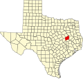
TXMap-doton-Oakwood.PNG
Location of Oakwood, Texas
Leon County Oakwood.svg
Coordinates: 31°35′05″N95°51′00″W / 31.58472°N 95.85000°W / 31.58472; -95.85000
Country United States
State Texas
Counties Leon, Freestone
Area
[1]
  Total1.13 sq mi (2.93 km2)
  Land1.13 sq mi (2.93 km2)
  Water0.00 sq mi (0.00 km2)
Elevation
[2]
282 ft (86 m)
Population
 (2020) [3]
  Total389
  Density455.35/sq mi (175.85/km2)
Time zone UTC-6 (Central (CST))
  Summer (DST) UTC-5 (CDT)
ZIP code
75855
Area code(s) 903, 430
FIPS code 48-53232 [4]
GNIS feature ID2413071 [2]
Website www.cityofoakwood.tx.citygovt.org
Oakwood welcome sign Oakwood, TX, sign IMG 3026.JPG
Oakwood welcome sign
U.S. Post Office in Oakwood U.S. Post Office, Oakwood, TX IMG 3027.JPG
U.S. Post Office in Oakwood

Oakwood is a town in Leon and Freestone counties in the U.S. state of Texas. The population was 389 at the 2020 census. [3] It was founded in 1872 as a stop on the International Railroad. [5]

Contents

Geography

Oakwood is located in northeastern Leon County. USGS topographic maps show the northern town boundary following the Leon/Freestone County line, but maps by the U.S. Census show the town extending slightly north into Freestone County.

U.S. Route 79 passes through the town as Broad Street, leading northeast 18 miles (29 km) to Palestine and southwest 15 miles (24 km) to Buffalo.

According to the United States Census Bureau, the town has a total area of 1.13 square miles (2.93 km2), all land. [3]

Demographics

Historical population
CensusPop.Note
1880 96
1890 231140.6%
1910 906
1920 1,10021.4%
1930 888−19.3%
1940 1,08622.3%
1950 759−30.1%
1960 716−5.7%
1970 547−23.6%
1980 60610.8%
1990 527−13.0%
2000 471−10.6%
2010 5108.3%
2020 389−23.7%
U.S. Decennial Census [6]
Oakwood racial composition as of 2020 [7]
(NH = Non-Hispanic) [a]
RaceNumberPercentage
White (NH)23259.64%
Black or African American (NH)11529.56%
Native American or Alaska Native (NH)30.77%
Asian (NH)51.29%
Some Other Race (NH)10.26%
Mixed/Multi-Racial (NH)215.4%
Hispanic or Latino 123.08%
Total389

As of the 2020 United States census, there were 389 people, 236 households, and 193 families residing in the town.

As of the census [4] of 2000, there were 471 people, 199 households, and 131 families residing in the town. The population density was 429.9 inhabitants per square mile (166.0/km2). There were 256 housing units at an average density of 233.7 per square mile (90.2/km2). The racial makeup of the town was 62.42% White, 35.03% African American, 0.21% Native American, 0.21% Asian, 1.70% from other races, and 0.42% from two or more races. Hispanic or Latino of any race were 3.18% of the population.

There were 199 households, out of which 23.6% had children under the age of 18 living with them, 44.2% were married couples living together, 17.1% had a female householder with no husband present, and 33.7% were non-families. 30.2% of all households were made up of individuals, and 16.1% had someone living alone who was 65 years of age or older. The average household size was 2.37 and the average family size was 2.94.

In the town, the population was spread out, with 24.0% under the age of 18, 7.9% from 18 to 24, 19.7% from 25 to 44, 27.6% from 45 to 64, and 20.8% who were 65 years of age or older. The median age was 44 years. For every 100 females, there were 88.4 males. For every 100 females age 18 and over, there were 82.7 males.

The median income for a household in the town was $25,625, and the median income for a family was $33,750. Males had a median income of $34,375 versus $20,938 for females. The per capita income for the town was $16,371. About 13.9% of families and 19.6% of the population were below the poverty line, including 14.3% of those under age 18 and 26.6% of those age 65 or over.

Education

The town is served by the Oakwood Independent School District.

Notable people

Climate

The climate in this area is characterized by hot, humid summers and generally mild to cool winters. According to the Köppen Climate Classification system, Oakwood has a humid subtropical climate, abbreviated "Cfa" on climate maps. [11]

See also

Related Research Articles

<span class="mw-page-title-main">Leon County, Texas</span> County in Texas, United States

Leon County is a county in the U.S. state of Texas. As of the 2020 census, its population was 15,719. Its county seat is Centerville.

<span class="mw-page-title-main">Freestone County, Texas</span> County in Texas, United States

Freestone County is a county in the east-central part of the U.S. state of Texas. As of the 2020 census, its population was 19,435. Its county seat is Fairfield. The county was created in 1850 and organized the next year.

<span class="mw-page-title-main">China Grove, Texas</span> Town in Texas, United States

China Grove is a town in Bexar County, Texas, United States, located on the far east side of San Antonio. The population was 1,141 at the 2020 census. It is part of the San Antonio Metropolitan Statistical Area.

<span class="mw-page-title-main">Round Mountain, Texas</span> Town in Blanco County, Texas, United States

Round Mountain is a town in Blanco County, Texas, United States. The population was 101 at the 2020 census.

<span class="mw-page-title-main">Santa Rosa, Texas</span> Town in Texas, United States

Santa Rosa is a town in Cameron County, Texas, United States. The population was 2,450 at the 2020 census. It is part of the Brownsville–Harlingen–Raymondville and the Matamoros–Brownsville metropolitan areas.

<span class="mw-page-title-main">Paducah, Texas</span> Town in Cottle County, Texas, United States

Paducah is a town in Cottle County, Texas, United States. The population was 1,063 at the 2020 census, down from 1,186 in 2010. It is the county seat of Cottle County. It is just south of the Texas Panhandle and east of the Llano Estacado.

<span class="mw-page-title-main">Fairfield, Texas</span> City in Texas, United States

Fairfield is a city and county seat of Freestone County, Texas, United States. The population was 2,850 at the 2020 census, down from 3,094 at the 2000 census. It was founded in 1851.

<span class="mw-page-title-main">Wortham, Texas</span> Town in Texas, United States

Wortham is a town in Freestone County, Texas, United States. The population was 980 at the 2020 census.

<span class="mw-page-title-main">Hamilton, Texas</span> City in Texas, United States

Hamilton is a city in and the county seat of Hamilton County, Texas, United States, located in the state's central region. Its population was 2,895 at the 2020 census.

<span class="mw-page-title-main">Rule, Texas</span> Town in Texas, United States

Rule is a town in Haskell County, Texas, United States. The population was 561 at the 2020 census, down from 636 at the 2010 census.

<span class="mw-page-title-main">Athens, Texas</span> City in Texas, United States

Athens is a city and the county seat of Henderson County, Texas, in the United States. As of the 2020 census, the city population was 12,857. The city has called itself the "Black-Eyed Pea Capital of the World." Athens was selected as one of the first "Certified Retirement Communities" in Texas. Athens was incorporated in 1856 and was named after Athens, the capital of Greece.

<span class="mw-page-title-main">Centerville, Texas</span> City in Texas, United States

Centerville is a city in Leon County, in the U.S. state of Texas. The population was 905 at the 2020 census. It is the county seat of Leon County. Centerville was so named as it is near the geographic center of Leon County.

<span class="mw-page-title-main">Jewett, Texas</span> City in Texas, United States

Jewett is a city in Leon County, Texas, United States. The population was 793 at the 2020 census. It was laid out in 1871 by the International Railroad Company.

<span class="mw-page-title-main">Natalia, Texas</span> City in Medina County, Texas, United States

Natalia is a city in Medina County, Texas, United States. The population was 1,202 at the 2020 census. It was founded in 1912 and was named after Natalie Pearson Nicholson, daughter of Frederick Stark Pearson, engineer, designer and builder of the Medina Dam.

<span class="mw-page-title-main">Dawson, Texas</span> Town in Texas, United States

Dawson is a town in Navarro County, in the U.S. state of Texas. The population was 815 at the 2020 census.

<span class="mw-page-title-main">Aspermont, Texas</span> Town in Texas, United States

Aspermont is a town in and the county seat of Stonewall County, Texas, United States. The population was 789 at the 2020 census.

<span class="mw-page-title-main">Lawn, Texas</span> Town in Texas, United States

Lawn is a town in Taylor County, Texas, United States. As of the 2020 census, the town population was 311. It is part of the Abilene, Texas Metropolitan Statistical Area.

<span class="mw-page-title-main">Trent, Texas</span> Town in Texas, United States

Trent is a town in Taylor County, Texas, United States, that was established in 1881. The population was 295 at the 2020 census. It is part of the Abilene, Texas Metropolitan Statistical Area. Trent, Texas was named in honor of West Texas pioneer and cattleman, Isaac Riley Trent.

<span class="mw-page-title-main">Woodville, Texas</span> Town in and county seat of Tyler County, Texas, United States

Woodville is a town in and the county seat of Tyler County, Texas, United States. The town is intersected by three U.S. Numbered Highways: U.S. Route 69, U.S. Route 190, and U.S. Route 287. The population was 2,403 at the 2020 census. It is the county seat of Tyler County. The town was named after George Tyler Wood, governor of Texas from 1847 to 1849.

<span class="mw-page-title-main">Streetman, Texas</span> Town in Freestone and Navarro counties in Texas, United States

Streetman is a town in Freestone and Navarro counties in Texas, United States. As of the 2020 census the population was 248.

References

  1. "2019 U.S. Gazetteer Files". United States Census Bureau. Retrieved August 7, 2020.
  2. 1 2 U.S. Geological Survey Geographic Names Information System: Oakwood, Texas
  3. 1 2 3 "Total Population: 2010 Census DEC Summary File 1 (P1), Oakwood town, Texas". data.census.gov. U.S. Census Bureau. Retrieved January 20, 2021.
  4. 1 2 "U.S. Census website". United States Census Bureau . Retrieved January 31, 2008.
  5. A Memorial and Biographical History of Navarro, Henderson, Anderson, Limestone, Freestone and Leon Counties, Texas. Chicago: Lewis Publishing Company. 1893. p. 468. Retrieved September 28, 2014.
  6. "Census of Population and Housing". Census.gov. Retrieved June 4, 2015.
  7. "Explore Census Data". data.census.gov. Retrieved May 25, 2022.
  8. https://www.census.gov/ [ not specific enough to verify ]
  9. "About the Hispanic Population and its Origin". www.census.gov. Retrieved May 18, 2022.
  10. David Warren Steel; Richard H. Hulan (2010). The Makers of the Sacred Harp. University of Illinois Press. pp. 131–. ISBN   978-0-252-07760-9.
  11. Climate Summary for Oakwood, Texas
  1. Note: the US Census treats Hispanic/Latino as an ethnic category. This table excludes Latinos from the racial categories and assigns them to a separate category. Hispanics/Latinos can be of any race. [8] [9]

Official website