"},"elevation_ft":{"wt":"1037"},"coordinates":{"wt":"{{coord|45|49|48|N|93|25|24|W|region:US-MN|display=inline,title}}"},"postal_code_type":{"wt":"[[ZIP code]]"},"postal_code":{"wt":"56358"},"area_code":{"wt":"[[Area code 320|320]]"},"blank_name":{"wt":"[[Federal Information Processing Standard|FIPS code]]"},"blank_info":{"wt":"27-48166{{cite web|url=https://www.census.gov |publisher=[[United States Census Bureau]] |access-date=2008-01-31 |title=U.S. Census website }}"},"blank1_name":{"wt":"[[Geographic Names Information System|GNIS]] feature ID"},"blank1_info":{"wt":"2395309{{GNIS|2395309}}"},"website":{"wt":""},"footnotes":{"wt":""},"pop_est_footnotes":{"wt":""}},"i":0}}]}" id="mwBw">City in Minnesota, United States
Ogilvie | |
---|---|
Motto: "We Are The Lions" | |
Coordinates: 45°49′48″N93°25′24″W / 45.83000°N 93.42333°W | |
Country | United States |
State | Minnesota |
County | Kanabec |
Area | |
• Total | 0.89 sq mi (2.31 km2) |
• Land | 0.89 sq mi (2.30 km2) |
• Water | 0.00 sq mi (0.00 km2) |
Elevation | 1,037 ft (316 m) |
Population (2020) | |
• Total | 388 |
• Density | 435.96/sq mi (168.34/km2) |
Time zone | UTC-6 (Central (CST)) |
• Summer (DST) | UTC-5 (CDT) |
ZIP code | 56358 |
Area code | 320 |
FIPS code | 27-48166 [3] |
GNIS feature ID | 2395309 [2] |
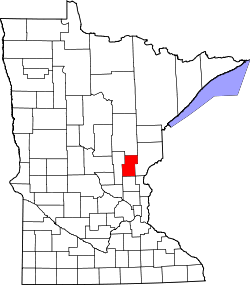
Ogilvie is a city in Kanabec County, Minnesota, United States. The population was 388 at the 2020 census. [4]
According to the United States Census Bureau, the city has a total area of 0.93 square miles (2.41 km2), all land. [5]
The Groundhouse River flows nearby.
The following roads serve as major routes through the community of Ogilvie.
Census | Pop. | Note | %± |
---|---|---|---|
1910 | 270 | — | |
1920 | 436 | 61.5% | |
1930 | 344 | −21.1% | |
1940 | 438 | 27.3% | |
1950 | 362 | −17.4% | |
1960 | 376 | 3.9% | |
1970 | 384 | 2.1% | |
1980 | 423 | 10.2% | |
1990 | 510 | 20.6% | |
2000 | 474 | −7.1% | |
2010 | 369 | −22.2% | |
2020 | 388 | 5.1% | |
U.S. Decennial Census [6] |
As of the census [7] of 2010, there were 369 people, 160 households, and 91 families residing in the city. The population density was 396.8 inhabitants per square mile (153.2/km2). There were 186 housing units at an average density of 200.0 per square mile (77.2/km2). The racial makeup of the city was 98.9% White, 0.3% Native American, and 0.8% from two or more races. Hispanic or Latino of any race were 0.3% of the population.
There were 160 households, of which 27.5% had children under the age of 18 living with them, 33.8% were married couples living together, 16.9% had a female householder with no husband present, 6.3% had a male householder with no wife present, and 43.1% were non-families. 30.6% of all households were made up of individuals, and 16.9% had someone living alone who was 65 years of age or older. The average household size was 2.31 and the average family size was 2.89.
The median age in the city was 41.3 years. 24.4% of residents were under the age of 18; 6.1% were between the ages of 18 and 24; 22.3% were from 25 to 44; 28.4% were from 45 to 64; and 18.7% were 65 years of age or older. The gender makeup of the city was 49.6% male and 50.4% female.
As of the census [3] of 2000, there were 474 people, 182 households, and 111 families residing in the city. The population density was 507.0 inhabitants per square mile (195.8/km2). There were 199 housing units at an average density of 212.9 per square mile (82.2/km2). The racial makeup of the city was 93.88% White, 0.42% African American, 2.11% Native American, 2.74% Asian, 0.21% from other races, and 0.63% from two or more races. Hispanic or Latino of any race were 0.63% of the population.
There were 182 households, out of which 39.0% had children under the age of 18 living with them, 37.9% were married couples living together, 15.9% had a female householder with no husband present, and 38.5% were non-families. 30.2% of all households were made up of individuals, and 13.2% had someone living alone who was 65 years of age or older. The average household size was 2.60 and the average family size was 3.13.
In the city, the population was spread out, with 32.3% under the age of 18, 8.0% from 18 to 24, 27.8% from 25 to 44, 19.4% from 45 to 64, and 12.4% who were 65 years of age or older. The median age was 32 years. For every 100 females, there were 89.6 males. For every 100 females age 18 and over, there were 86.6 males.
The median income in 2000 for a household in the city was $27,292, and the median income for a family was $33,125. Males had a median income of $22,083 versus $21,250 for females. The per capita income for the city was $15,198. About 8.8% of families and 14.6% of the population were below the poverty line, including 20.0% of those under age 18 and 6.7% of those age 65 or over.
A post office called Ogilvie has been in operation since 1899. [8] The city was named for Oric Ogilvie Whited, a local landowner. [9]
The Ogilvie Raceway, a 3/8 mile Dirt clay oval race track, opened on May 29, 2009.
The sports teams at Ogilvie High School are known as the Ogilvie Lions.
Idun Township is a township in Aitkin County, Minnesota, United States. The population was 259 as of the 2010 census.
Wagner Township is a township in Aitkin County, Minnesota, United States. The population was 332 as of the 2010 census.
Williams Township is a township in Aitkin County, Minnesota, United States. The population was 144 as of the 2010 census.
Lake Shore is a city in Cass County, Minnesota, United States. The population was 1,056 at the 2020 census. It is part of the Brainerd Micropolitan Statistical Area.
Ann Lake Township is a township in Kanabec County, Minnesota, United States. The population was 377 at the 2000 census.
Arthur Township is a township in Kanabec County, Minnesota, United States. The population was 1,905 at the 2000 census.
Brunswick Township is a township in Kanabec County, Minnesota, United States. The population was 1,263 at the 2000 census. Originally called Grass Lake Township, it was renamed after the community of Brunswick, Minnesota, in 1883.
Comfort Township is a township in Kanabec County, Minnesota, United States. The population was 931 at the 2000 census.
Ford Township is a township in Kanabec County, Minnesota, United States. Organized as a township on May 16, 1916, the population was 177 at the 2000 census.
Grass Lake Township is a township in Kanabec County, Minnesota, United States. The population was 928 at the 2000 census.
Grasston is a city in Kanabec County, Minnesota, United States. The population was 158 at the 2010 census.
Hillman Township is a township in Kanabec County, Minnesota, United States. The population was 384 at the 2000 census.
Kanabec Township is a township in Kanabec County, Minnesota, United States. The population was 853 at the 2000 census.
Knife Lake Township is a township in Kanabec County, Minnesota, United States. The population was 1,049 at the 2000 census.
Kroschel Township is a township in Kanabec County, Minnesota, United States. The population was 218 at the 2000 census.
Mora is a city and the county seat of Kanabec County, Minnesota It is located at the junction of Minnesota highways 23 and 65 and is along the Snake River. The population was 3,665 at the 2020 Census.
Quamba is a city in Kanabec County, Minnesota, United States. The population was 107 at the 2020 census. It is the only city in Minnesota that begins with the letter Q.
Whited Township is a township in Kanabec County, Minnesota, United States. The population was 808 at the 2000 census.
Erhard is a city in Otter Tail County, Minnesota, United States. The population was 132 at the 2020 census.
Braham is a city in Isanti and Kanabec counties in the U.S. state of Minnesota. The population was 1,769 at the 2020 census.