
Marycrest College Historic District is located on a bluff overlooking the West End of Davenport, Iowa, United States. The district encompasses the campus of Marycrest College, which was a small, private collegiate institution. The school became Teikyo Marycrest University and finally Marycrest International University after affiliating with a Japanese educational consortium during the 1990s. The school closed in 2002 because of financial shortcomings. The campus has been listed on the Davenport Register of Historic Properties and on the National Register of Historic Places since 2004. At the time of its nomination, the historic district consisted of 13 resources, including six contributing buildings and five non-contributing buildings. Two of the buildings were already individually listed on the National Register.

The New Harmony Historic District is a National Historic Landmark District in New Harmony, Indiana. It received its landmark designation in 1965, and was placed on the National Register of Historic Places in 1966, with a boundary increase in 2000. The district includes properties within the Historic New Harmony State Historic Site. Twelve buildings from the early 19th century and twenty from the mid-19th century are within the district. The original boundary was Main Street between Granary and Church Streets and was later increased to include the area bounded by North and Steam Mill Streets and between Third and Arthur Streets.

The South Central Falls Historic District is a historic district in Central Falls, Rhode Island. It is a predominantly residential area, densely populated, which was developed most heavily in the late 19th century. It is bounded roughly by Broad Street to the east, the Pawtucket city line to the south, Dexter Street to the west, and Rand Street and Jenks Park to the north. It has 377 contributing buildings, most of which were built before 1920. The district was added to the National Register of Historic Places in 1991.

The Lake Linden Historic District is located in the village of Lake Linden in Houghton County, Michigan.

The Carlowville Historic District is a historic district in the community of Carlowville, Alabama, United States. It covers 780 acres (320 ha) and is centered on Alabama State Route 89 and Dallas County roads 4, 47 and 417. It was placed on the National Register of Historic Places on January 18, 1978.

The Northville Historic District is located in Northville, Michigan. It was designated a Michigan State Historic Site in 1970 and listed on the National Register of Historic Places in 1972. The district is roughly bounded by Cady Street, Rogers Street, and Randolph Street; alterations to the boundaries of the city-designated district in 2003 and 2007 included structures on the opposite sides of the original bounding streets within the district. The district is located in the heart of old Northville, and is primarily residential, although the 73 contributing structures, include several commercial buildings and a church. The majority of the district contains Gothic Revival houses constructed between 1860 and 1880.

The Arbor Hill Historic District–Ten Broeck Triangle, originally the Ten Broeck Historic District, is a seven-block area located within the Arbor Hill neighborhood north of what is today downtown Albany, New York, United States. In 1979 its easternmost third, the Ten Broeck Triangle, the second oldest residential neighborhood in the city, was recognized as a historic district and listed on the National Register of Historic Places. Four years later, the district was increased to its current size and renamed to reflect its expansion to include some of the rest of Arbor Hill.

The Old City Hall, also known as Oxford Flats, is located just north of downtown along a commercial corridor in Davenport, Iowa, United States. It was individually listed on the National Register of Historic Places in 1983. In 2020 it was included as a contributing property in the Davenport Downtown Commercial Historic District.

The Downtown Waterbury Historic District is the core of the city of Waterbury, Connecticut, United States. It is a roughly rectangular area centered on West Main Street and Waterbury Green, the remnant of the original town commons, which has been called "one of the most attractive downtown parks in New England."
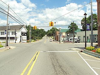
The Metamora Crossroads Historic District is a historic district centered at the intersection of Oak and High Street in the small village of Metamora in Metamora Township in Lapeer County, Michigan. It was designated as a Michigan State Historic Site and also added to the National Register of Historic Places on July 19, 1984.

The Piety Hill Historic District is a historic district located in downtown Lapeer in Lapeer County, Michigan, USA. It was designated as a Michigan State Historic Site and also added to the National Register of Historic Places on July 26, 1985.
The Carriage House Historic District in Miles City, Montana was added to the National Register of Historic Places in 1991. The historic district contained 54 contributing buildings and 21 non-contributing ones, on the 900 to 1100 blocks of Pleasant and Palmer Avenues and on cross streets. Nine locations feature signs describing the property.
The Sturdevant Southwest Historic District is a nationally recognized historic district located in Waverly, Iowa, United States. It was listed on the National Register of Historic Places in 2016. At the time of its nomination it contained 183 resources, which included 120 contributing buildings, one contributing structure, and 62 non-contributing buildings. The historic district is a residential area west of the Cedar River and south of a commercial area. It was home to middle-to-working-class families and a few business and professional people. Most of the primary resources in the district are houses, and the secondary resources are either carriage houses, garages, or city barns. The primary resources that are not residential include First Baptist Church (1901), the Farmers Exchange Produce Building, the Farmers Exchange Office Building (1935), and St. Andrew's Episcopal Church (1958). The contributing structure is St. Andrew's bell tower. The Congregational Church was also located here until it was torn down. All but three houses contribute to the historical significance of the district, but a majority of the secondary resources do not.

Washington Residential Historic District is a nationally recognized historic district located in Dubuque, Iowa, United States. It was listed on the National Register of Historic Places in 2015. At the time of its nomination it consisted of 327 resources, which included 262 contributing buildings, 61 non-contributing buildings, and two non-contributing objects. This is one of the early residential areas of Dubuque, and was home to its German community. It also defines the "walkable city" with commercial, industrial, and institutional buildings located here. There are a number of churches in the district from various denominations. Of particular interest are St. Mary's Catholic Church (1866), St. John's Lutheran Church (1880), and St. Matthew's Lutheran Church (1908). A significant number of the buildings were constructed in brick, and the vast majority of the buildings in the district were built by 1891. Vernacular structures are commonplace here, as are various Victorian styles. Hollenfelz House (1891) and the Dubuque Casket Company building (1894) are individually listed on the National Register. The former St. Mary's Catholic Church complex forms its own historic district within this one.

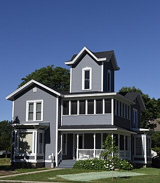
The Prof. J. L. Budd, Sarah M., and Etta Budd House, also known as the Youth Recovery House, is a historic building located in Ames, Iowa, United States. It was built as a single family residence in 1885. The two-story brick structure was built using Italianate elements. After World War II it was converted into an apartment building, and later into institutional housing. The attached 1½-story Colonial Revival cottage was moved onto the property in 1963, and used for office space. The house is named for Joseph Lancaster Budd, a botanist at what is now Iowa State University, who helped establish the school's national reputation in horticulture. Sarah was his wife, and Etta was their daughter. She was an artist who was influential in bringing George Washington Carver to Iowa State College for his undergraduate education. Carver resided here briefly in 1891. The house was individually listed on the National Register of Historic Places in 2001, and it was included as a contributing property in the Old Town Historic District in 2004.

Eagar Townsite Historic District is a section of the town of Eagar, Arizona which has been designated a National Historic Place. Sitting on roughly 54 acres, the site contains 37 structures, 21 of which have historical significance. The period of significance is from 1886, the year the townsite was founded, through 1942, which represents the significant period of development of the town. The site was added to the Register on July 23, 1993.

The Asbury Historic District is a 288-acre (117 ha) historic district encompassing the community of Asbury in Franklin Township of Warren County, New Jersey. It is bounded by County Route 632, County Route 643, Maple Avenue, Kitchen Road, and School Street and extends along the Musconetcong River into Bethlehem Township of Hunterdon County. It was listed on the National Register of Historic Places on March 19, 1993 for its significance in architecture, industry, religion, community development, politics/government, and commerce. The district includes 141 contributing buildings, a contributing structure, two contributing sites, and four contributing objects.
The Decorah Commercial Historic District is a nationally recognized historic district located in Decorah, Iowa, United States. It was listed on the National Register of Historic Places in 2017. At the time of its nomination it contained 126 resources, which included 85 contributing buildings, one contributing structure, and 40 non-contributing buildings. The historic district covers most of the city's central business district. Water Street, which is a major thoroughfare through the district was named after a millrace (non-extant) that rerouted water from the Upper Iowa River to serve the needs of the mills and the commercial district. The land here is relatively flat and allowed for a linear shopping area. The Broadway–Phelps Park Historic District is largely a residential area that is located to the south.
Woodlawn, Alabama is a community in Jefferson County, Alabama, which is now a neighborhood within the city of Birmingham, Alabama. It grew as an independent community, and became the City of Woodlawn, and built a substantial City Hall building in 1908, but was annexed by Birmingham in 1910. The community area experienced a surge of growth after it was annexed.


