Winchester National Cemetery is a United States National Cemetery located in the city of Winchester in Frederick County, Virginia. Administered by the United States Department of Veterans Affairs, it encompasses 4.9 acres (2.0 ha), and as of the end of 2005, it had 5,561 interments. It is closed to new interments.

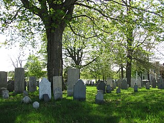
The First Burial Ground or Park Street Burial Ground is a historic cemetery on Park Street near Centre Street in Woburn, Massachusetts. Established c. 1646, it is the city's first and oldest cemetery. It occupies a 1.4-acre (0.57 ha) parcel at the corner of Park and Centre Streets near Woburn Square. Most of the burials took place before 1794, and are marked by slate headstones. The last documented burial took place in 1903. In a manner typical of early colonial cemeteries, there is no formal circulation pattern, and graves are not laid out in any formal, organized manner.

The Latham Confederate Monument in Hopkinsville, Kentucky's Riverside Cemetery, is a monument on the National Register of Historic Places.

The Danielson Main Street Historic District encompasses the historic late 19th-century commercial business district of the borough of Danielson in the town of Killingly, Connecticut. It extends along Main Street, between the Five Mile River and Spring Street, including a few buildings on adjacent side streets, representing the area's growth as a commercial and civic center in the late 19th and early 20th centuries. It was listed on the National Register of Historic Places in 1992.

Hillside Cemetery, also known as the North Burying Ground, is a historic cemetery on Depot and Nutting Roads in Westford, Massachusetts. The cemetery was established in 1753, and is the burial site of a number of people important in local history. It contains approximately 300 burials, and continues in active use. The cemetery was listed on the National Register of Historic Places in 2005.

High Street Cemetery is a historic cemetery at 45 High Street in Danvers, Massachusetts. The 0.6-acre (0.24 ha) cemetery is one of the older cemeteries in town, and occupies a prominent location in the town center.

The Mechanic Street Cemetery is a historic early cemetery on Mechanic Street in Westfield, Massachusetts. The 4-acre (1.6 ha) cemetery is the city's oldest, with the oldest documented grave dating to 1683. It was used as a burying ground until the late 19th century, although its use began to decline in the middle of the century, with the advent of the popular rural cemetery movement, which was reflected in Westfield with the establishment of the new Pine Hill Cemetery in 1842. No burials were recorded in the 20th century. Although the cemetery has been subjected to some maintenance work, it continues to suffer the effects of vandalism and weather. The cemetery was listed on the National Register of Historic Places in 2002.

Amherst West Cemetery is a historic cemetery on Triangle Street in Amherst, Massachusetts. The 4 acres (1.6 ha) cemetery was first laid out in 1730, when the voters of Hadley elected to establish a new burying ground in its eastern precinct. When the area was separated as Amherst in 1786, the property was taken over by the newly established town. In addition to being the burial site of many of Amherst's early settlers, it is also the burial site of members of the Dickinson family, most notably the poet Emily Dickinson. Their family plot is set off from the rest of the cemetery by a wrought iron fence.

Center Cemetery is a historic cemetery on the south side of Sam Hill Road in Worthington, Massachusetts. The 2.4-acre (0.97 ha) cemetery was established c. 1774, and continues to be used today. Its burials include many of the founders and early settlers of Worthington, and of families influential in the growth and development of the town. The cemetery listed on the National Register of Historic Places in 2004.

North Cemetery is a historic cemetery in Worthington, Massachusetts. The 3.5-acre (1.4 ha) municipal cemetery is located at the corner of Cold and North Streets not far from Worthington Corners; it is the town's largest cemetery. The cemetery was listed on the National Register of Historic Places in 2004, for its funerary architecture and its role as the burial ground for the town's early settlers.

The East Main Street Cemetery is a historic cemetery on East Main Street in Dalton, Massachusetts. The cemetery is one of the oldest in the town, with grave markers dating to the 1780s. It was founded on land owned by the Chamberlin family, whose identified graves make up about 20 percent of roughly 250 gravesites. The cemetery was listed on the National Register of Historic Places in 2000.

Maple Street Cemetery is a historic cemetery on Maple Street in Adams, Massachusetts. Established about 1760, it is the town's oldest cemetery, serving as a burying ground for its early Quaker settlers, as well as for some of its prominent 19th-century citizens. It was listed on the National Register of Historic Places in 2004.

Spring Hill Cemetery is a historic cemetery at High and Brown Streets in Marlborough, Massachusetts. Established in 1675, it is the city's oldest cemetery. It has about 650 known burials, dating from its establishment to 1977. It is located on a 2.62-acre (1.06 ha) parcel on a hill just east of the downtown area, and is accessed via a single entrance marked by granite posts at High and Brown Streets. Burials are laid out generally in rows, with headstones facing west. There are four earth-covered tombs near the entrance dating to the first half of the 19th century. Another prominent burial is that of Marlborough's first minister, William Brimsmead.

Wilson Cemetery is a historic cemetery at Wilson Street on Marlborough, Massachusetts. The cemetery is a 1.22 acres (0.49 ha) parcel that is usually accessed via the adjacent Evergreen Cemetery. Wilson Cemetery was established in 1764, and contains marked graves dating between 1764 and 2000. Most of the burials date to the 19th century. The older portion of the cemetery is to the north, where graves are arrayed in rough north-south rows. A central pathway separates this section from the southern portion, which is laid out in a more formal rectilinear grid. The most prominent burial is the tomb of Robert Eames, a veteran of the American Revolutionary War.

The Gideon Putnam Burying Ground is located on South Franklin Street in Saratoga Springs, New York, United States. It contains over 150 graves of early and mid-19th century residents of the city, all from the period between 1812 and 1871. It was restored in the 1980s after suffering from almost a century of neglect.
Old North Cemetery is a historic cemetery on Maplewood Avenue in Portsmouth, New Hampshire. It is a roughly 1.5-acre (0.61 ha) parcel of land north of the city center on the shore of North Mill Pond. Its earliest burials are dated to 1751, although it was not formally established as a cemetery until 1753. It is the largest of the city's 18th century cemeteries, and is remarkable for the relatively distant locations some of the stonecarvers came from whose work appears in it. The cemetery was listed on the National Register of Historic Places in 1978.

The Kent Burying Ground is a historic cemetery at the corner of Fayette Corner Road and Oak Hill Road in Fayette, Maine. Established in 1880 by Elias Kent, it is unusual for its layout of concentric rings around a central monument, only known in one other cemetery in the state, the Wing Family Cemetery in nearby Wayne. The cemetery was listed on the National Register of Historic Places in 2008.

Brookside Cemetery is a historic cemetery located along North Union Street in the city of Tecumseh in northern Lenawee County, Michigan. It was designated as a Michigan Historic Site and added to the National Register of Historic Places on August 13, 1986.

The Old Center Burying Yard or Center Cemetery is a historic cemetery at 30 N. Main Street in West Hartford, Connecticut. Established in 1719, it was the town's first cemetery, and its only burying ground for about seventy years. Many of West Hartford's prominent early settlers are buried here, including Noah Webster Sr. and his wife Mercy. The oldest portion of the cemetery remained in regular use until 1868, with the last documented burial in its newer section in 1971. It was listed on the National Register of Historic Places in 2002.

The Old North Cemetery is a cemetery on Main Street in the Clay-Arsenal neighborhood north of downtown Hartford, Connecticut. It was established in 1807, and was the city's second municipal cemetery. It was the principal burying ground for the city's elites for many years, and has a fine collection of 19th-century funerary art. It was listed on the National Register of Historic Places in 1998. Although burials continue to take place there occasionally, they only take place on existing plots.