The Indiana Harbor and Ship Canal is an artificial waterway on the southwest shore of Lake Michigan, in East Chicago, Indiana, which connects the Grand Calumet River to Lake Michigan. It consists of two branch canals, the 1.25 mile (2 km) Lake George Branch and the 2 mile (3 km) long Grand Calumet River Branch which join to form the main Indiana Harbor Canal.

The Mississippi River – Gulf Outlet Canal is a 76 mi (122 km) channel constructed by the United States Army Corps of Engineers at the direction of Congress in the mid-20th century that provided a shorter route between the Gulf of Mexico and New Orleans' inner harbor Industrial Canal via the Intracoastal Waterway. In 2005, although disputed by the Corps of Engineers, the MRGO channeled Hurricane Katrina's storm surge into the heart of Greater New Orleans, contributing significantly to the subsequent multiple engineering failures experienced by the region's hurricane protection network. In the aftermath the channel was closed. A permanent storm surge barrier was constructed in the MRGO in 2009, and the channel has been closed to maritime shipping.
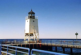
The Charlevoix South Pier Light Station is located on Lake Michigan at the entrance to Lake Charlevoix in Charlevoix County in the U.S. state of Michigan at the end of the south pier/breakwater of the channel leading to Round Lake in the city of Charlevoix.

St. Clair Flats Front and Rear Range Light are two lighthouse structures situated off the southeastern tip of Harsens Island at Lake St. Clair.

The Manistique Breakwater lighthouse is located in the harbor of Manistique, Michigan. It was listed on the National Register of Historic Places in 2005.

The Muskegon South Pierhead Light or Muskegon Pier Light is a lighthouse located on the channel in the harbor of Muskegon, Michigan.

The Port Washington Breakwater Light is a lighthouse built in 1935 at the entrance to the Port Washington, Wisconsin harbor on Lake Michigan. The second tower at this location, it remains an active aid to navigation. It was listed on the National Register of Historic Places in 2018.

The Green Bay Harbor Entrance Light is an offshore lighthouse near Green Bay, Wisconsin. Located 10 miles (16 km) from the mouth of the Fox River, it was erected to signal the entrance to Green Bay.

The Grand Marais Harbor of Refuge Inner and Outer Lights are a pair of lighthouses located on the west pier at the entry to Grand Marais Harbor of Refuge, in Grand Marais, Michigan. They were listed on the National Register of Historic Places in 2012.

The Navigation Structures at Pentwater Harbor are navigational structures located at the west end of Lowell Street in Pentwater, Michigan. They were listed on the National Register of Historic Places in 2001.

The Navigation Structures at Frankfort Harbor are a collection of breakwaters, piers, and other structures in Lake Michigan located at the foot of Second Street in Frankfort, Michigan. They were listed on the National Register of Historic Places in 1997.

Grand Haven South Pierhead Inner Light is the inner light of two lighthouses on the south pier of Grand Haven, Michigan where the Grand River enters Lake Michigan. A lighthouse was first lit there in 1839. The lighthouse was put up for sale in 2009 under the National Historic Lighthouse Preservation Act. The City of Grand Haven now owns the pier, but it is maintained by the Army Corps of Engineers.

The Keweenaw Waterway Lower Entrance Light, also known as the Portage Entry Light, is a lighthouse located at the south end of breakwater at mouth of the Portage River in Torch Lake Township. It was listed on the National Register of Historic Places in 2014.

The Keweenaw Waterway Upper Entrance Light is a lighthouse located at the north end of the Portage River in McLain State Park in Hancock Township, Michigan. It was listed on the National Register of Historic Places in 2014.

The Navigation Structures at Saugatuck Harbor consist of two piers flanking the mouth of the Kalamazoo River on the shore of Lake Michigan near Saugatuck, Michigan. The structures were listed on the National Register of Historic Places in 2001.

The Manistee Harbor, South Breakwater is a navigational structure located at the mouth of the Manistee River, in Manistee, Michigan. It was listed on the National Register of Historic Places in 1995. The breakwater is significant due to its construction, which represents a final stage in the United States Army Corps of Engineers's use of timber crib substructures in pier and breakwater construction.
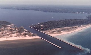
The Navigation Structures at White Lake Harbor area set of piers protecting the channel connecting Lake Michigan and White Lake, located at the end of Lau Road near Whitehall, Michigan. It was listed on the National Register of Historic Places in 2000.

The Piers and Revetments at Grand Haven, Michigan are navigational structures located at the mouth of the Grand River in Grand Haven, Michigan. The structures were listed on the National Register of Historic Places in 1995.

The Navigation Structures at Harbor Beach Harbor are a series of breakwaters located in Lake Huron, on North Lakeshore Drive in Harbor Beach, Michigan. They were listed on the National Register of Historic Places in 1997.

