
Hot Springs is a resort city in the state of Arkansas and the county seat of Garland County. The city is located in the Ouachita Mountains among the U.S. Interior Highlands, and is set among several natural hot springs for which the city is named. As of the 2020 United States Census, the city had a population of 37,930, making it the eleventh-most populous city in Arkansas.

Camden is a city in and the county seat of Ouachita County in the south-central part of the U.S. state of Arkansas. The city is located about 100 miles south of Little Rock. Situated on bluffs overlooking the Ouachita River, the city developed because of the river.

Hillcrest Historic District is a historic neighborhood in Little Rock, Arkansas that was listed on the National Register of Historic Places on December 18, 1990. It is often referred to as Hillcrest by the people who live there, although the district's boundaries actually encompass several neighborhood additions that were once part of the incorporated town of Pulaski Heights. The town of Pulaski Heights was annexed to the city of Little Rock in 1916. The Hillcrest Residents Association uses the tagline "Heart of Little Rock" because the area is located almost directly in the center of the city and was the first street car suburb in Little Rock and among the first of neighborhoods in Arkansas.
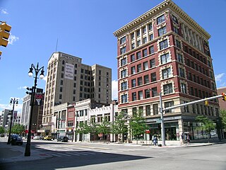
The Broadway Avenue Historic District is a historic district located on a single city block along Broadway Avenue between Gratiot and East Grand River in downtown Detroit, Michigan. It was listed on the National Register of Historic Places in 2004. The Broadway Avenue Historic District joins the Randolph Street Commercial Buildings Historic District, a rare surviving commercial area which dates from the 1840s.

This is a list of the National Register of Historic Places listings in Ouachita County, Arkansas.

Mount Nord Historic District is a historic district in Fayetteville, Arkansas encompassing one city block with five properties. The district lies atop a rise of about 140 feet (43 m) above the surrounding area. The properties were built between 1901 and 1925 in various architectural styles, and the area was listed on the National Register of Historic Places in 1982.

The Smackover Historic Commercial District encompasses the civic and commercial heart of the small town of Smackover, Arkansas. It consists of sixteen buildings lining a single block of Broadway north of 7th Avenue. The area is reflective of Smackover's explosive growth following the discovery of oil in 1925; most of the buildings were built between 1925 and 1940. They are mostly vernacular commercial buildings, one or two stories in height, with flat roofs obscured by a parapet on the main facade. Also included in the district are the Methodist Episcopal church, the old fire station, and the old city hall and jail. The district was listed on the National Register of Historic Places in 1990.

The Clifton and Greening Streets Historic District is a residential historic district in Camden, Arkansas. It encompasses a neighborhood area that typifies the growth of the city between about 1890 and 1940. When first listed on the National Register of Historic Places in 1998, it consisted of properties on Clifton Street between Cleveland and Dallas Avenues, and on Greening Street between Cleveland and Spring Avenues. The district has been enlarged three times, each time to add a few additional properties.
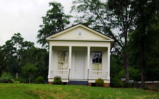
The Leake–Ingham Building is a historic commercial building in Camden, Arkansas, United States. It is located behind the McCollum-Chidester House at 926 Washington Street NW, and is part of the Ouachita County Historical Society Museum. It is one of the oldest commercial buildings in Camden. The single-story Greek Revival structure was built c. 1850 by William Leake, a prominent Camden attorney, and has a distinctive Greek temple front. It was originally located on a prominent corner of the city, at Washington and Harrison Streets. Leake operated a law practice from the building until 1866 with various partners, after which it was used to house government offices, and later Camden's first library. Threatened with demolition in the 1950s, it was moved several times before its acquisition by the historical society.

Oakland Cemetery is a historic cemetery in Camden, Arkansas, located on Maul Road between Pearl Street and Madison Avenue. Established in 1830, it is the city's oldest cemetery. It consists of just over 7 acres (2.8 ha) of land donated in that year by William L. Bradley, one of Camden's founders. It is the burial site of many of Camden's leading citizens. Among them is James Thomas Elliott (1823–1875), a former Confederate soldier who represented Arkansas's 2nd District as a Republican.

The Ouachita County Courthouse is located at 145 Jefferson Avenue in Camden, Arkansas, the seat of Ouachita County. The two-story brick and concrete structure was designed by Little Rock architect Thomas Harding, and completed in 1933. The architecturally distinctive building exhibits a restrained Colonial Revival style (which was then passing out of fashion, with elements of Art Deco. It is a T-shaped building with symmetrical wings flanking a Classical style columned and gabled portico.

The Washington Street Historic District of Camden, Arkansas, encompasses an area that has been a fashionable residential area for much of the city's history. It includes six blocks of Washington Street, three of Graham Street, and three connecting streets. The oldest houses in this area are pre-Civil War Greek Revival houses, built in the 1840s and 1850s when Camden was at its height as a major regional center of the cotton trade. Another round of development took place late in the 19th century after the railroad arrived, resulting in a number of Queen Anne, Colonial Revival, and Classical Revival houses. The last major building spurt took place during southern Arkansas' oil boom in the 1920s and 1930s, when Mission/Spanish Revival, Mediterranean, and English Revival houses were built. The district included 68 contributing properties when it was first listed on the National Register of Historic Places in 2010. Six structures were previously listed separately on the National Register. The district was enlarged in 2018.

The Arkadelphia Commercial Historic District encompasses the historic commercial core of Arkadelphia, Arkansas, the county seat of Clark County. Arkadelphia was settled in 1842, and its commercial district is located in one of the older parts of the city, near the Ouachita River. Most of the buildings were built between c. 1890 and c. 1920, and are built out of brick and masonry; the oldest building in the district is estimated to have been built in 1870.

The West Garrison Avenue Historic District is a historic district encompassing the oldest commercial section of Fort Smith, Arkansas. When listed on the National Register of Historic Places in 1979, the district included just a five-block stretch of Garrison Avenue, the major east–west thoroughfare in the city and one its oldest, dating to the city's founding in 1838. The district included more than fifty historically significant buildings built before 1912. The area was significantly affected by a major tornado in September 1996, in which thirteen historic buildings were destroyed and others damaged. The district was subsequently enlarged in 2001 to encompass 175 buildings with historic significance to 1951. These buildings are located along the length of Garrison Avenue, as well as Rogers Avenue and North "A" Street, which run parallel to Garrison, and the connecting north–south blocks.

The Mena Commercial Historic District encompasses the historic downtown area of Mena, Arkansas, the county seat of Polk County in western Arkansas. The district extends along Mena Street between Port Arthur and Gillham Avenues, extending a short way to the south on Sherwood Avenue, opposite the railroad tracks for which the town's existence is responsible. Mena was founded as a major railroad service town for the Kansas City, Pittsburg and Gulf Railroad, as its site was located midway between Port Arthur, Texas and Kansas City, Missouri. The railroad located a major service yard here, and the town grew up around it. Most of its commercial center was developed between 1896 and 1940, with a variety of one and two-story commercial brick buildings in typical early 20th-century styles. The district, listed on the National Register of Historic Places in 2009, includes four properties previously listed separately: the railroad station, Mena City Hall, the former Elks Lodge, and the former Studebaker Showroom.

The Batesville Commercial Historic District encompasses about four city blocks of the historic downtown of Batesville, Arkansas. This area's current appearance is largely the result of development between about 1880 and the 1940s, although it includes a portion of Arkansas' oldest platted Main Street, dating to 1821. When originally listed on the National Register of Historic Places in 1982, the district included 25 historic properties on two blocks of Main Street, on either side of Central Avenue, as well as a few properties on Central. In 1990 the size of the district was more than doubled, adding two more city blocks on Main Street and 36 buildings. Most of the buildings are brick and masonry commercial structures, two stories in height, with party walls joining them at the sides.

The Peter Joplin Commercial Block is a historic commercial building at 426-443 Ouachita Street in Hot Springs, Arkansas. It is a two-story masonry structure, with retail storefronts on the ground floor and offices above. It is architecturally undistinguished, with nods toward the Tudor Revival in its styling. Built in 1905, after a fire had swept through the area, it is one of the only buildings in the area to survive an even larger fire in 1913. As such, it is a rare surviving example of early 20th century commercial architecture.

The Hamp Williams Building is a historic commercial building at 500-504 Ouachita Avenue in Hot Springs, Arkansas. It is a two-story masonry structure, built out of granite and tile, and stands across from the Garland County Courthouse. Its main facade is divided into three storefronts, and has a tile mansard roof with a deep bracketed cornice. It was built in 1920 to house the Hamp Williams Automobile Company, and was at the time of its construction one of the city's largest commercial and retail spaces.

The Camp Ouachita Girl Scout Camp Historic District encompasses a campground area built by crews of the Civilian Conservation Corps in the 1930s on the northern shore of Lake Sylvia, a man-made lake in the eastern part of Ouachita National Forest. The center of the campground, including its Great Hall and administration buildings, is located at the northern tip of Lake Sylvia, with cabins, comfort facilities, and other infrastructure arrayed around the northern and western sides of the lake. It was the first Girl Scout camp in the state, and is a well-preserved example of the Rustic style of architecture for which the CCC is known.

The Atkins Commercial Historic District encompasses the historic business district of Atkins, Arkansas. It extends for two blocks on Main Street and 1st Street, between Church and 2nd Avenues. This area was largely developed between 1890 and 1959 as a trade and manufacturing center for the surrounding area, with most of its architecture dating before 1921. Most of the buildings are brick single-story buildings with vernacular commercial designs.


